Adventure is the name of the game
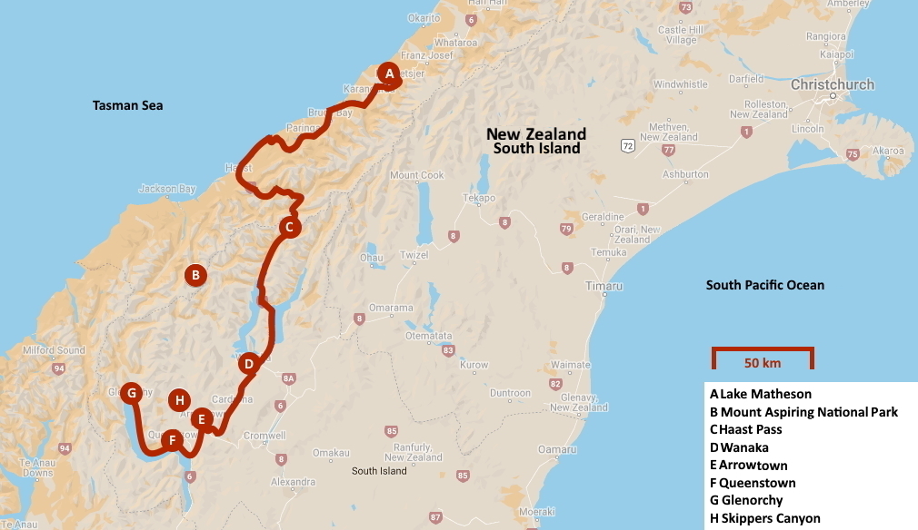
New Zealand | Anno 2019
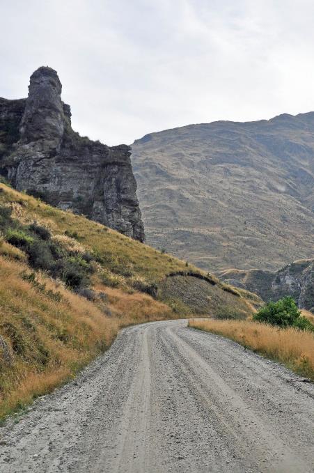
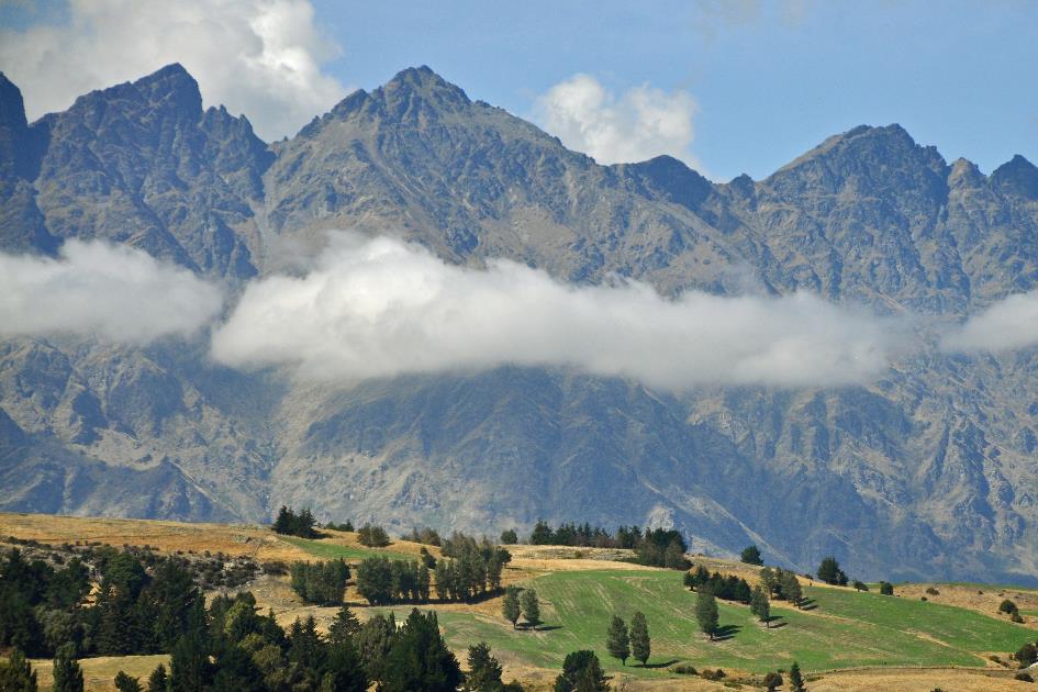
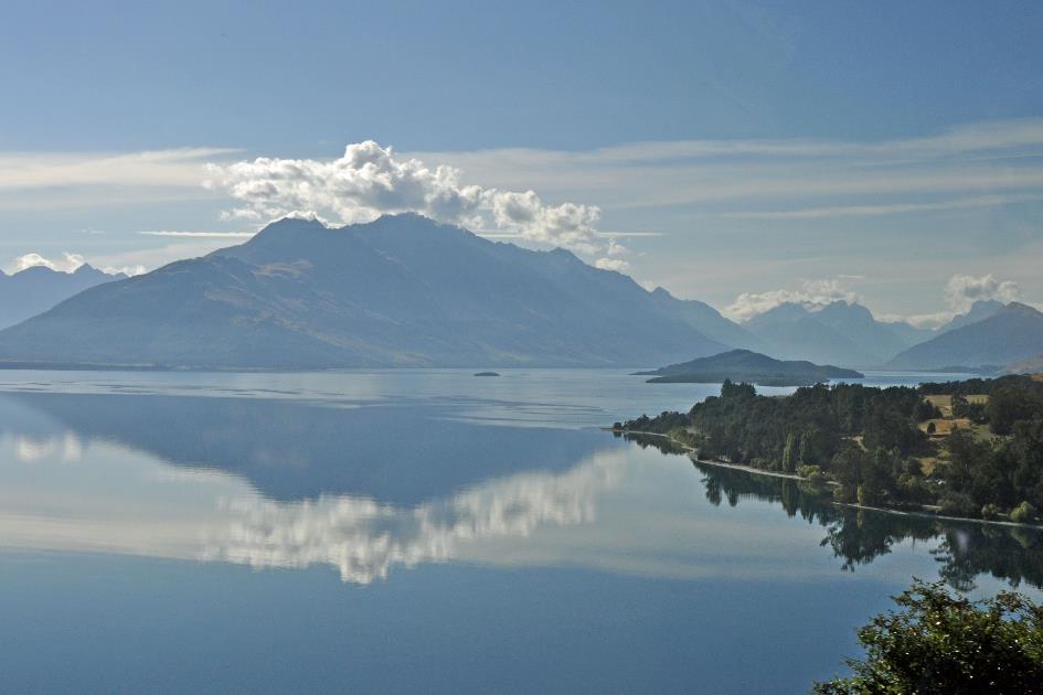
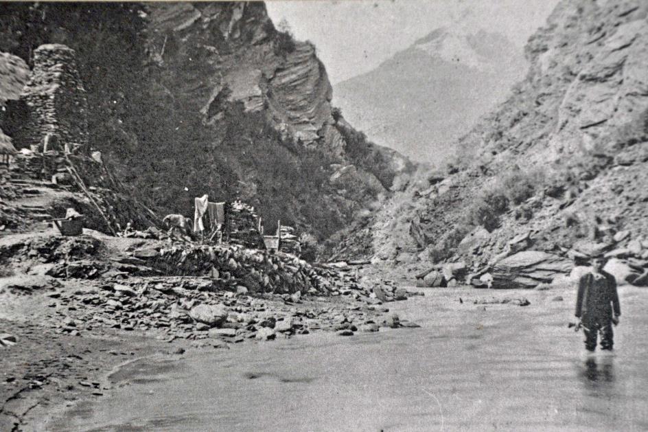
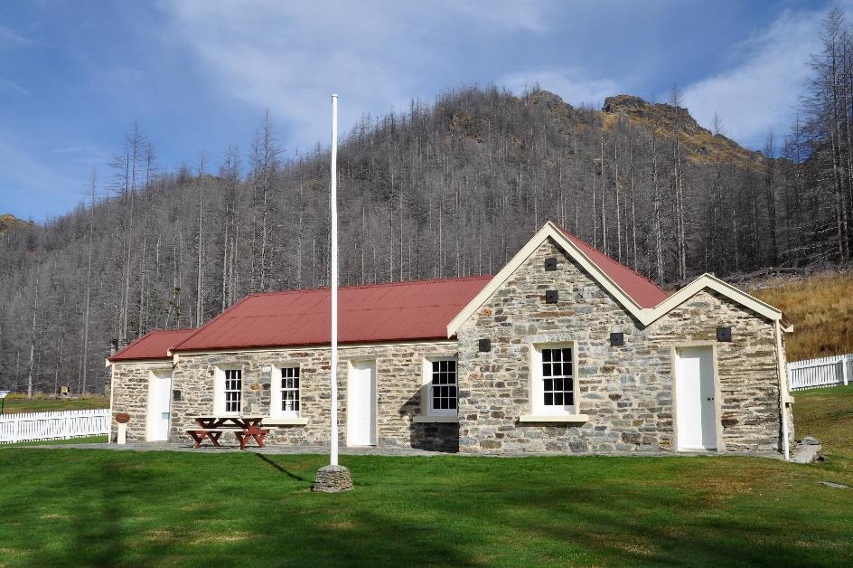
Tuesday, March 19 | Fox Village – Wanaka
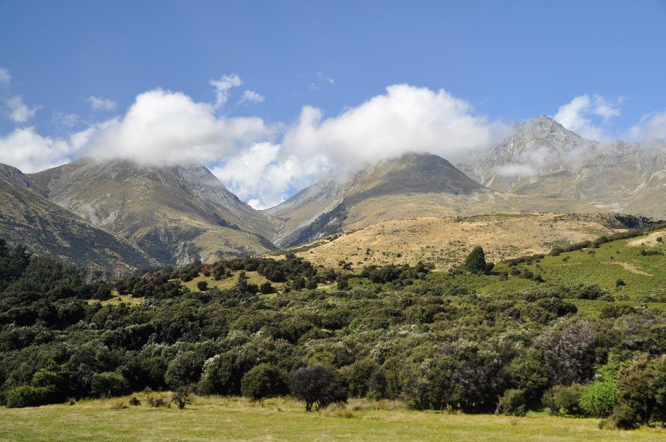
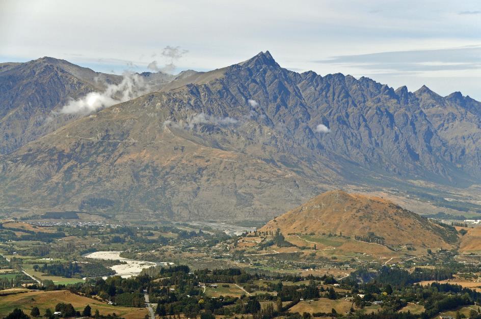
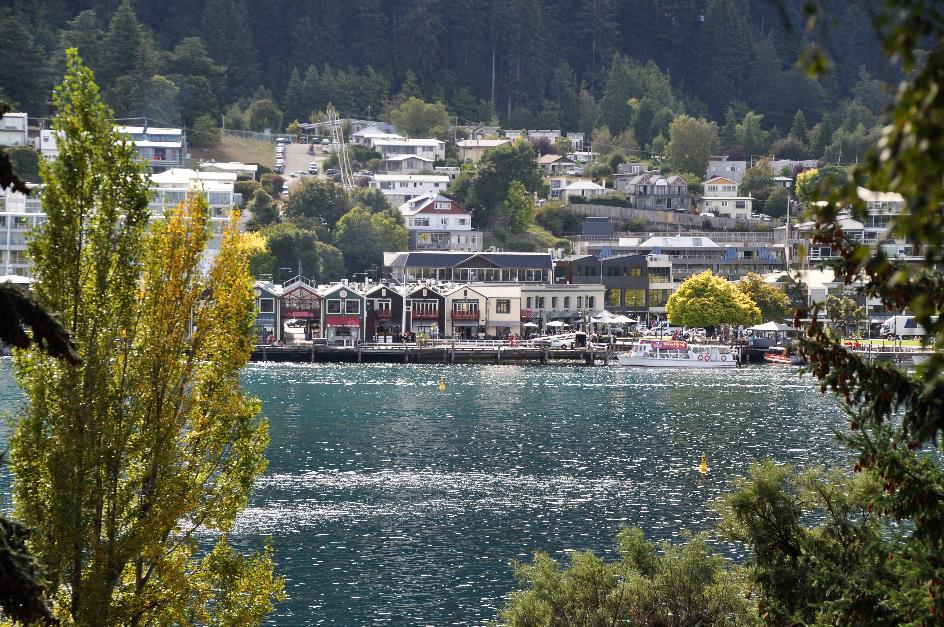
Wednesday, March 20 | Wanaka - Glenorchy – Queenstown
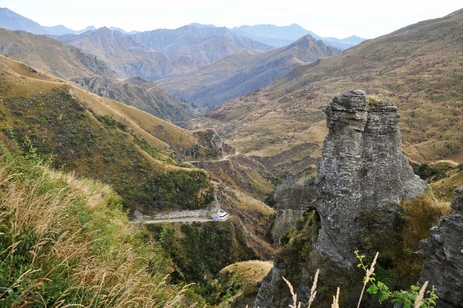
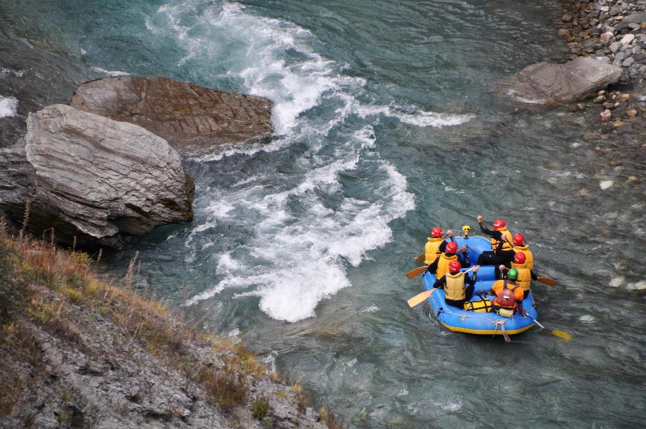
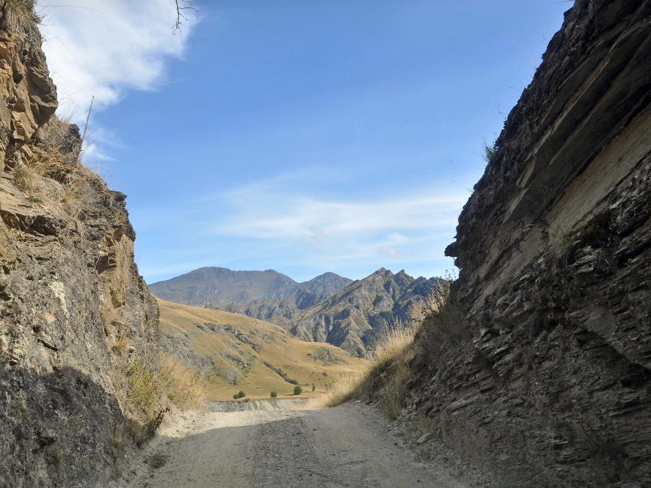
Thursday, March 21 | Queenstown – Skippers Canyon
Tuesday, March 19 | Fox Village – Wanaka
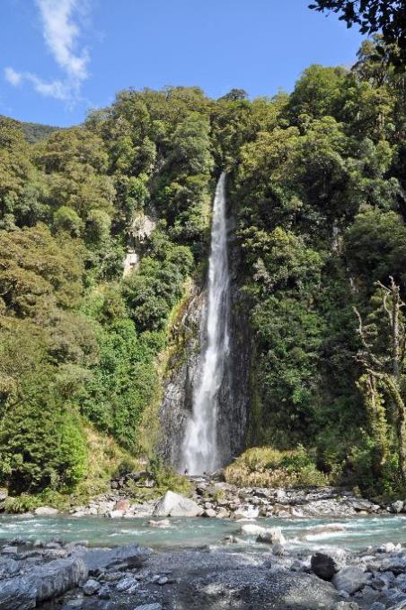
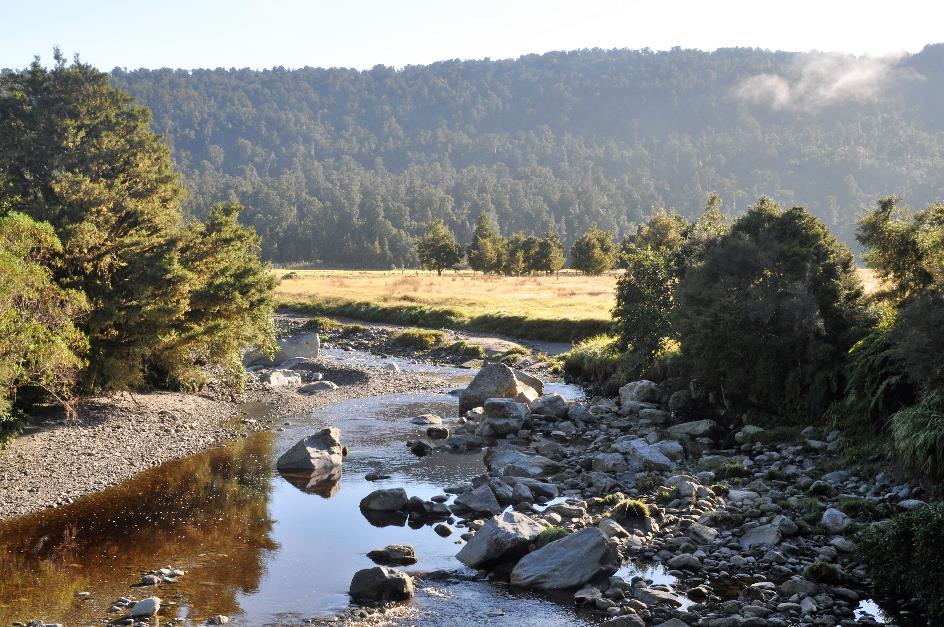
In its better days – meaning during the last ice age – the Fox Glacier reached all the way to the coastline. However, that has not been the case for a long time. Over the past fourteen thousand years, the glacier has progressively retreated further inland. Nowadays, you have to go 23 km from the coast to find its tip.
Over the past fourteen thousand years, the Fox Glacier has retreated 23 km
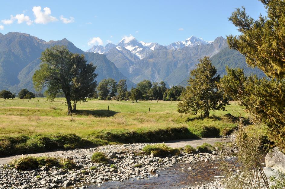
Mount Tasman, Clearwater River
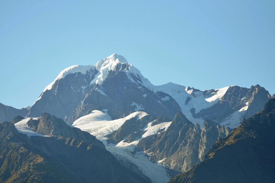
Mount Tasman
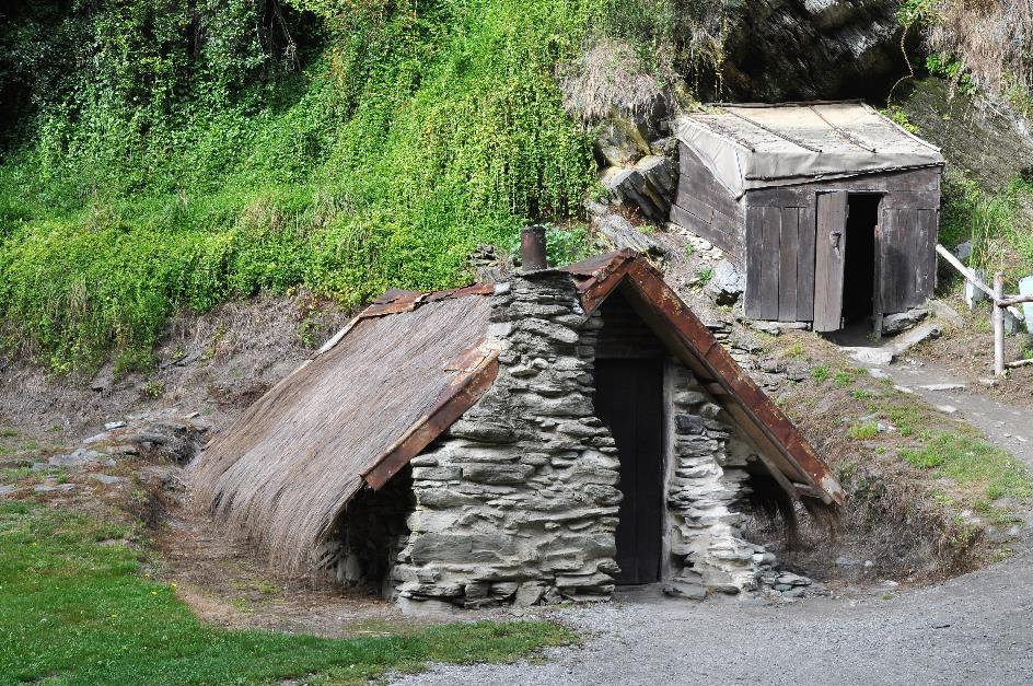
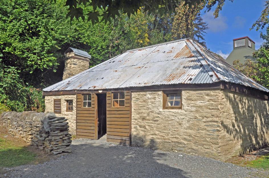
The presence of such an immense ice mass in the glacier valley has undoubtedly left its mark. Moraines are everywhere. But none of those places can compare to Lake Matheson. A classic example of a kettle lake, formed by dead ice left behind by the glacier.
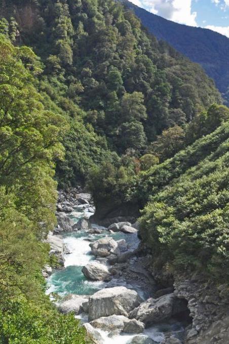
Clearwater River
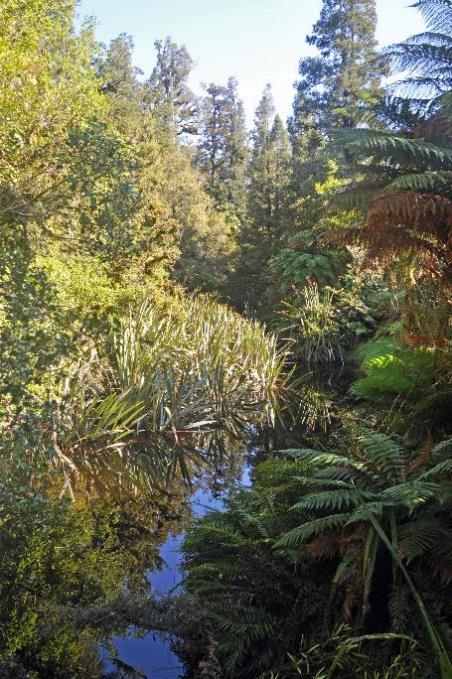
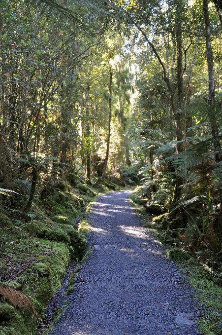
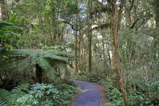
They call it one of the most beautiful walks in New Zealand, the 4.4 km trail around the lake. Curious, we cross the suspension bridge over the Clearwater. It won't take long before that bold claim is proven true.
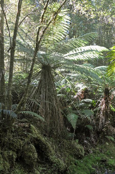
A comfortable gravel path, over a meter wide, quickly leads us through lush, almost subtropical vegetation. On both sides, a virtually impenetrable wall of trees, shrubs, tree ferns, climbing plants, lichens, and epiphytes rises meters high. Birds are heard all around, but sightings are rare.
With its pristine flora, this temperate rainforest could pass for a humid habitat from the Mesozoic era
Clearwater River |
|
Kahikatea (white pine) |
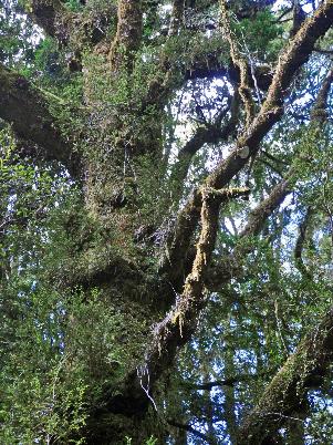
Those who hold on to a strong Swiss feeling from the mountain peaks and glaciers of the Southern Alps need only look around here to see that contradicted. This temperate rainforest is so exotic, almost fairy-tale-like.
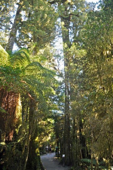
It took nature five thousand years to build this beautiful forest on the bare moraine around the lake. Ancient podocarps are the main inhabitants, and as a species, these giant trees existed during the time of the dinosaurs. This was one of the reasons why the BBC chose this location for the filming of Walking with Dinosaurs. With its pristine flora, this temperate rainforest could easily pass for a humid habitat from the Mesozoic era. Living dinosaurs were later added to this setting by the film makers using sophisticated animation techniques.
We've already encountered the rimu, or red pine. New to us in the podocarp family is the kahikatea, the white pine. Once, these were the tallest trees in the country. Before settlers arrived with axes and saws, you could easily find kahikateas reaching eighty meters. Nowadays, they are at most 55 to 60 meters tall.
At least, as far as you can find kahikateas in New Zealand. It is estimated that a whopping 98 % of the original forests have disappeared. This decline is not so much due to lumberjacks, as they found the wood somewhat inferior – not strong enough and too susceptible to rot. The kahikatea suffered primarily because the humid environments in which it thrives gradually disappeared from the landscape. Partly due to deforestation and partly due to draining swampy terrain.
Closer to the ground, we notice a wood fern with spore heaps in the shape of a kidney. Something similar applies to the umbrella moss, where the reproductive organs hang like a little umbrella over the plant.
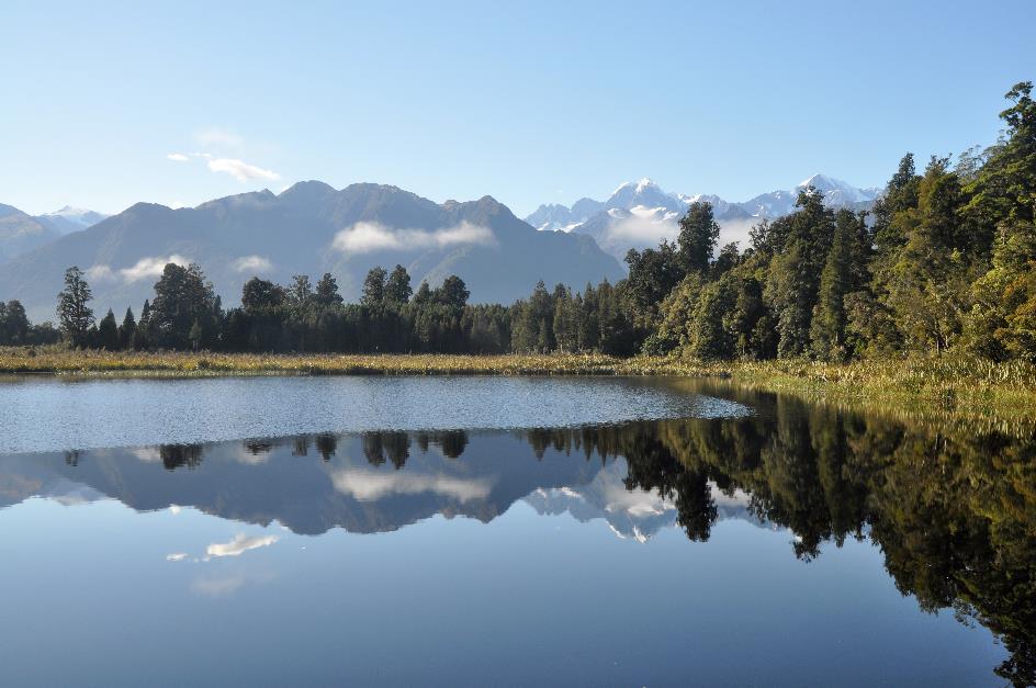
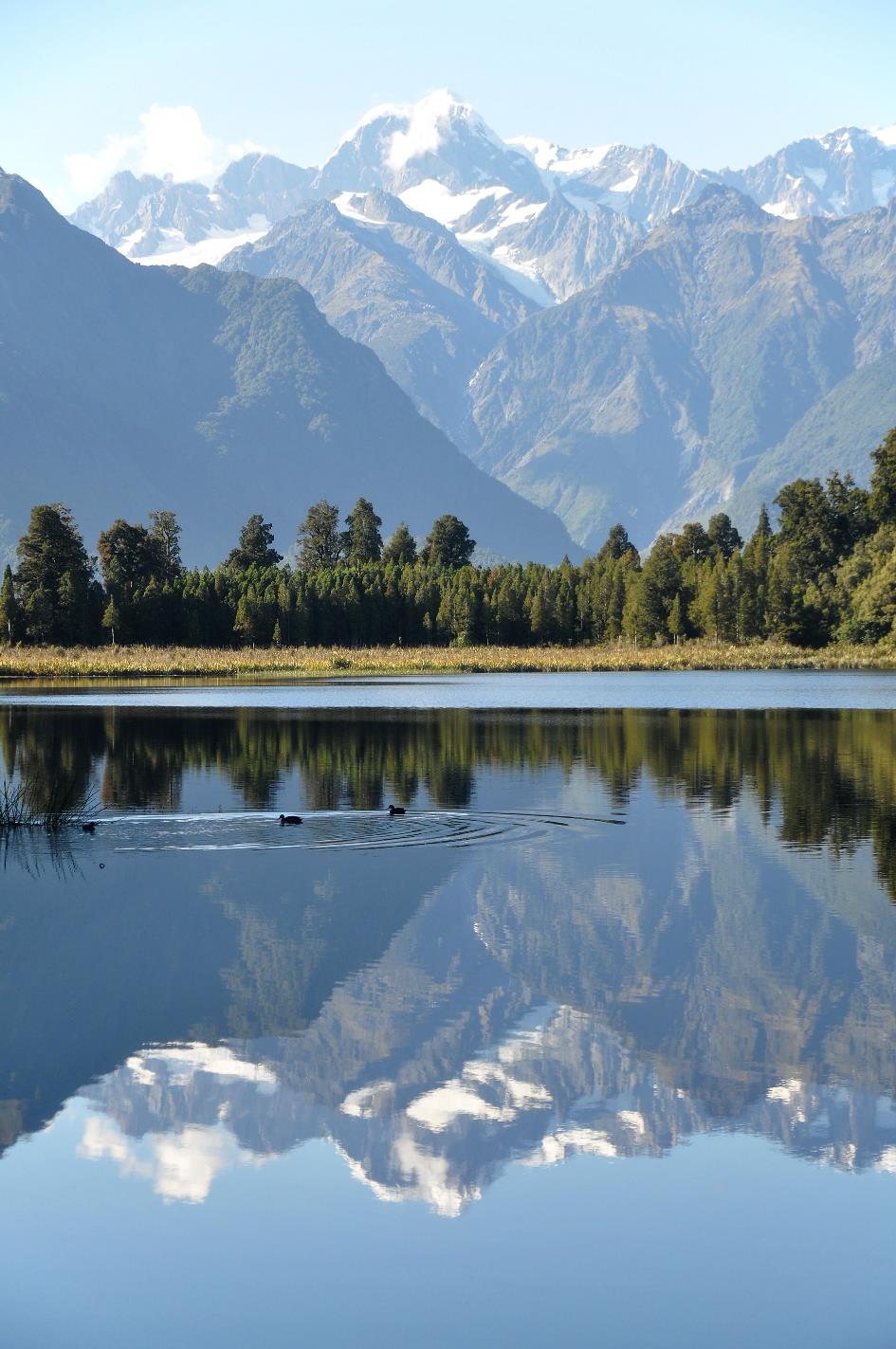
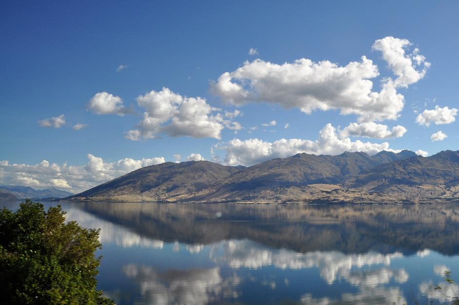
They call it The Perfect Reflection, and that's not even an exaggeration
We almost forgot – that's what happens when you get lost in the flora. Lake Matheson owes its fame not at all to its enchanting flora. It is the vistas of the snow-capped peaks of the Southern Alps that make this walk stand out. With the added value of their flawless reflection in the lake.
Mount Tasman, Lake Matheson
Everything is in our favour; the conditions are perfect. The lake is almost ripple-free. There's not a cloud in the sky; the sun shines high in the blue heavens. The white peaks and the grey-blue ridges rise clear and unapproachable above the forests, with here and there one of those typical long, white strands of mist. And all of it is perfectly reflected on the water surface, with Mount Tasman and Mount Cook in the leading roles.
They call it The Perfect Reflection, and that's not even an exaggeration. Take a photo and turn your camera upside down, and you'll have the exact same image on your screen. The fact that this postcard view has made it onto beer bottles, cookie tins, and even a postage stamp should come as no surprise.
This is partly thanks to the composition of the water. It has a dark brown colour due to the minuscule organisms dissolved in it, originating from the humus brought in by rainwater from the forests. This creates a dark, neutral background that allows for crystal-clear reflections.
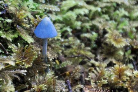
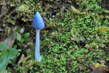
Let's call it the Smurf’s mushroom, this heavenly blue entoloma hochstetteri
Entoloma hochstetteri aka the Smurf’s mushroom |
|
Weeping pine |
We're not done exploring the local flora yet, as we're suddenly surprised by an Entoloma hochstetteri. Let's call it the Smurf’s mushroom, this heavenly blue fungus that unexpectedly pops up amidst the green. In a podocarp forest like this, it feels right at home. Despite its unusual blue appearance, you can find it all along the West Coast, both on the North Island and the South Island. Whether it's poisonous or not, science has yet to determine. However, we don't envision a blue mushroom on our plate anytime soon.
We don't envision a blue mushroom on our plate anytime soon
|
|
Entoloma hochstetteri |
Much more familiar to us is the ponga, a ubiquitous tree fern standing about six meters tall. It often grows in clusters, as its rhizomes propagate underground.
Ponga |
|
Podocarp Forest |
On the other hand, we don't get to see the endemic New Zealand longfin eel. Nevertheless, these dark, tannin-rich waters are teeming with them, according to the information boards. True to real eels, the New Zealand longfin eel spends the vast majority of its life in freshwater, only rushing to the sea towards the end of its life.
New Zealand longfin eels are the largest true eels in the world
Where and how fertilization takes place is unknown, but eventually, pregnant females always appear in the same place. It's not the Sargasso Sea, as is customary for European eels, but rather an area near the Tonga Islands, five thousand kilometres away from here.
Upon arrival, the females release their eggs – somewhere between one and twenty million – after which they promptly meet their end. All in all, it seems like an unnecessary journey because the larvae drift on autopilot for fifteen months back to the shores of New Zealand, thanks to the prevailing ocean currents.
Off the coast, they then spend a year in estuaries, transforming from glass eels into small eels. Now comes the hard part – returning to the place where their mother came from. The tidal currents give them an initial push, but then they have to do the job themselves.
Once mature, they become real giants. A female can grow up to two meters long and weigh 25 kg. They are the largest true eels in the world. And quite delicious too, if you ask the Māori. Because they were well aware of the eel life cycle, they would appear at the shores of Lake Matheson every season to stock up.
|
|
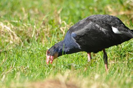
Pūkeko or Australasian swamphen |
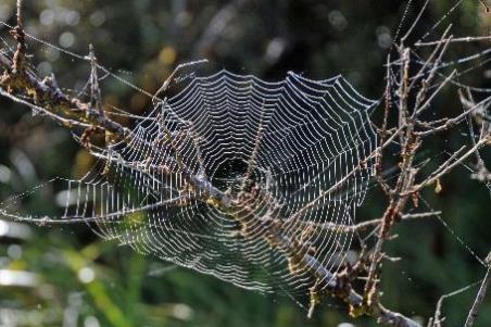
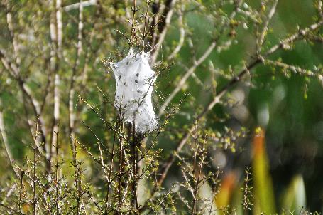
So we end up back in the open field. Strange, bag-shaped tissues hang between the branches of the bushes, undoubtedly the work of diligent spiders. Further on in the grassland, a handful of pūkekos are foraging for their meal. They have become a familiar sight, these Australasian swamphens.
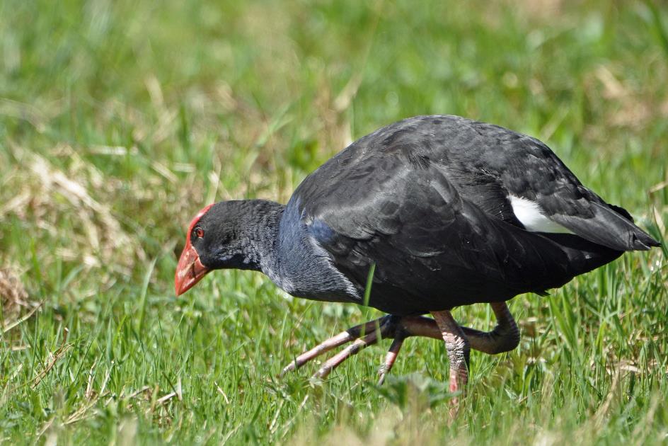
They have become a familiar sight, these Australasian swamphens
We have about 270 km ahead of us now. Almost half of that route will take us along the coast again. After that, we leave the Tasman Sea behind for good and head into the rugged inland.
Soon, we cross the Fox, Waiho's little sister. With white foam caps, the grey-green meltwater from the glacier cascades through the narrow, rocky bed. A walk through the moraine of the Fox Glacier is also an option here, just like yesterday when we walked along the Waiho to the tip of the Franz Josef Glacier. But currently, that route is closed because the path needs to be repaired, landslides having disrupted it.
From the longfin eels of Lake Matheson to the salmon of the Paringa Valley, that's just a small step. Cultivated salmon, to be precise, as that is what Brenda and Graham Monk have been involved in at their Salmon Farm for almost a quarter of a century. They produce eight to ten tons of salmon here every year.
The water of the Waituna, a cool, clear tributary of the Paringa, is reportedly highly suitable for this. However, one must be cautious with the rivers on the west coast, as they can become unpredictable. So, the salmon are housed in floating docks that neatly follow the water level. For lunch, we are served delicious fresh salmon.
Landslides have disrupted the path through the moraine of the Fox Glacier
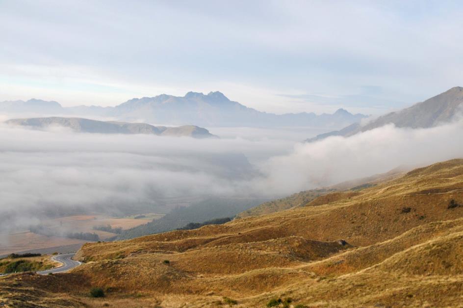
Just before two, SH6 starts flirting with the coastline again. However, we don't notice much of it for now because mist from the sea has claimed the slopes. It's a strange experience after the perfect blue sky of this morning. It's a cautious navigation along the winding road, in an endless game of climbing and descending. Encountering a lone cyclist here is quite surprising.
In the lower coastal areas, we no longer have to contend with the mists. Endless walls of exotic green now line the road. New Zealand truly lives up to its green name here.
Until, after a turn, the one-lane bridge over the Haast River emerges. Just before its mouth, the meandering river turns out to be enormous. The bridge is a whopping seven hundred meters long. It takes us a full minute to cross.
You can barely see if a vehicle has appeared at the other end. The usual rule – first come, first served – isn't of much use here. Therefore, every two hundred meters, a Passing Bay has been built where vehicles can pass each other.
The fact that the bed of the Haast River takes on such impressive dimensions here is not surprising. The river drains several imposing glacier valleys. During the ice ages, the ice here was hundreds of meters thick. The Haast Glacier even extended beyond the coastline, reaching far into the sea.
During the ice ages, the ice here was hundreds of meters thick
Haast River
Upstream, we now follow the Haast River on its left bank. It was the gold prospector Charles Cameron who, in 1863, became the first European to traverse this valley. However, Julius von Haast paid no heed when he repeated this feat a few weeks later, christening the valley – along with the river, glacier, mountain pass, and village – with his name.
It was no easy task to construct a road through this valley over the Southern Alps, even though the glacier had already taken care of most of the work. As early as the 1870s, heavily laden packhorses traversed this valley, following the ancient paths of the Māori who sought food and pounamu here in the past. However, it wasn't until 1929 that efforts were made to establish a proper road.
Four hundred men set to work with pickaxes, shovels, and horse-drawn carts; they had little more than that. The climate didn't provide much help either. Experiencing four seasons in one day is not uncommon here – a clear summer day can end in snow flurries by evening. As if that weren't enough, the Second World War threw a spanner in the works.
The fact that the project took almost forty years is hardly surprising. It wasn't until 1965 that the connection between the coastal area and the interior was completed. Even then, it was not until 1995 that the entire route was fully paved. A world of difference from the ease with which we casually cruise over the comfortable asphalt road today.
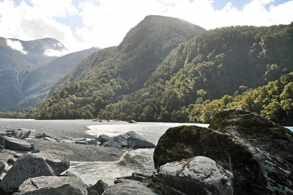
For now, we are hardly climbing. On both sides, the immense walls of the glacier valley rise high above us. We briefly descend through the dense vegetation to the river bank. As if scattered by a giant hand, large boulders lie there along the water's edge. On the opposite side, densely forested, dark green hills rise six to seven hundred meters high. Just beyond them should be the snow-capped peaks of the MacFarlane Ridge, but we see nothing of that. Below, the blue-green meltwater peacefully flows through the channels of the meandering river. Its bed is three to four hundred meters wide here. One can only imagine the impact when turbulent water pours down the full width here.
It was no easy task to construct a road through this valley over the Southern Alps
Haast River
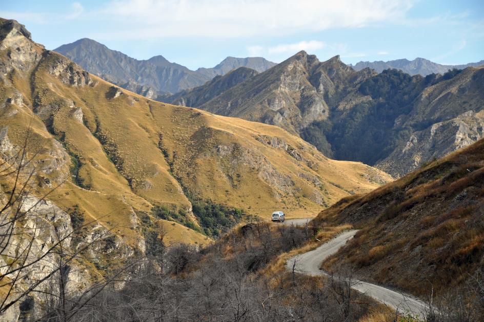
For more than forty kilometres, the road takes us eastward, deeper into the inland. Until, in a right-angle turn, it suddenly comes to an end. Now, we head directly south. Briefly, we get a glimpse of the monumental glacier valley of Landsborough. In the distance, the 2,640 m Mount Hooker should tower above the scene. Should, because clouds have the snowy peak in their grasp.
Shortly afterward, we enter Mount Aspiring National Park. With its area of 3,562 km², this is the third-largest national park in New Zealand.
Gradually, the valley narrows. At Pleasant Flat, it forces us to the right bank of the river. However, the gradient remains negligible – a hundred meters over a distance of 50 km. So, a zero point two percent incline.
To Thunder Creek Waterfalls |
|
|
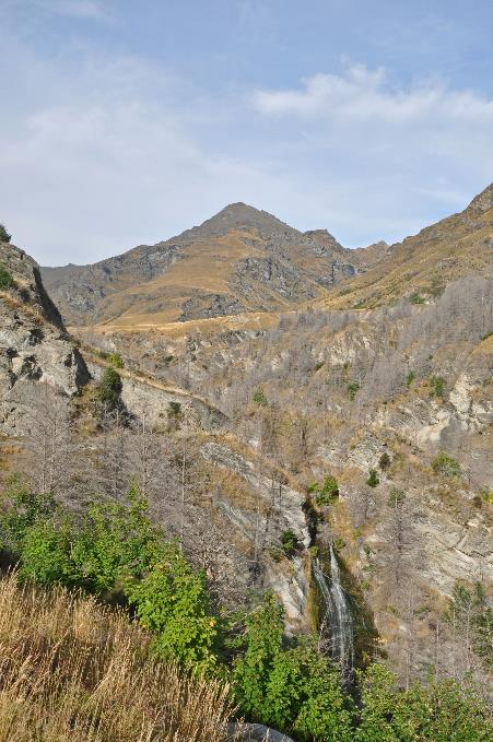
At times, the valley even takes on the appearance of a narrow canyon. This is evident at Thunder Creek Waterfalls, where a tributary cascades almost vertically downward over a height of 28 meters. A canyon of 28 meters deep is the result of the Haast River's erosion over the past twelve thousand years since the glaciers retreated – an average of two millimetres of erosion per year.
The river must manoeuvre through a far too narrow channel filled with boulders
Thunder Creek Waterfalls |
|
Gates of Haast |
Gradually, it becomes serious. The real climb to Haast Pass is imminent. Not that we should imagine complicated situations with hairpin bends or the like. For a short while, the valley narrows into a steep V-shaped trough, but our route on the map is essentially a straight line.
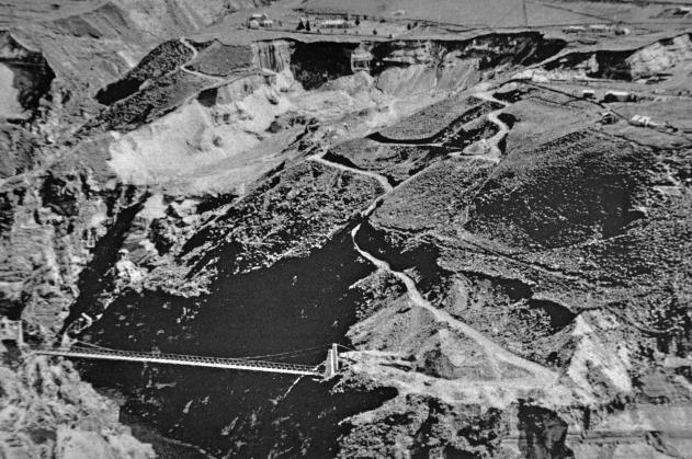
They call this place the Gates of Haast. Here, the river must force its way through a far too narrow channel filled with boulders. This naturally results in spectacle. Due to the dense vegetation, we don't get to see much of it, except from the one-lane bridge, where we can catch a glimpse of the wildly foaming, blue-green water.
It doesn't take long before the valley widens again into a broader trough. The Haast flows calmly through its spacious riverbed, unaware of the spectacle awaiting it shortly. In long, straight stretches, SH6 leads us to the ridge between the two valleys.
Just before four, we reach Haast Pass, a straight stretch of road through a forest of southern beech trees. You've crossed the mountain pass before you realize it. It's not really high, just 563 meters. We owe this to the glaciers of yore, as they suppressed this landscape for millennia.
What lies ahead of us is the mirror image of what lies behind us – a broad glacier valley where a river finds its way downhill. The difference is that the water of the Makarora is seeking the Pacific Ocean, while the Haast flows toward the Tasman Sea.
You've crossed the mountain pass before you realize it. We owe this to the glaciers of yore, as they suppressed this landscape for millennia
Makarora
Around five kilometres further, the glacier valley of Wanaka unfolds in all its grandeur. The Makarora flows calmly over its rocky bed through the wide sediment plain. Meanwhile, we are well aware of the force that such seemingly innocent rivers can unleash.
And so, we arrive in Makarora, a tiny settlement where tourism plays a significant role. You can take helicopter flights above the mountains, explore the Makarora with a jet boat, or savour delicious ice cream. We opt for the latter.
Everything seems to come together to create the perfect reflection
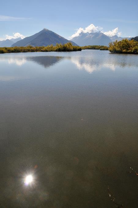
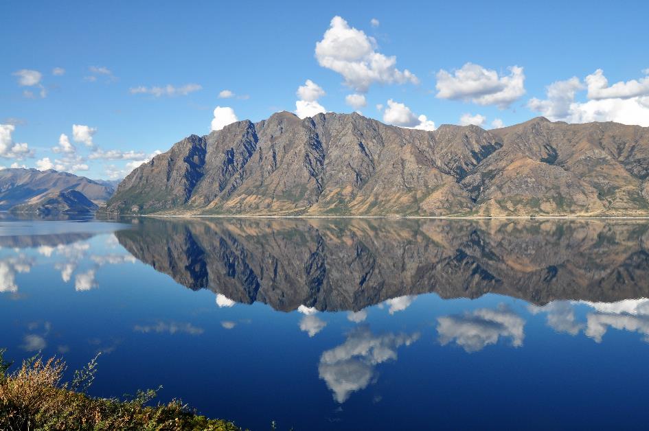
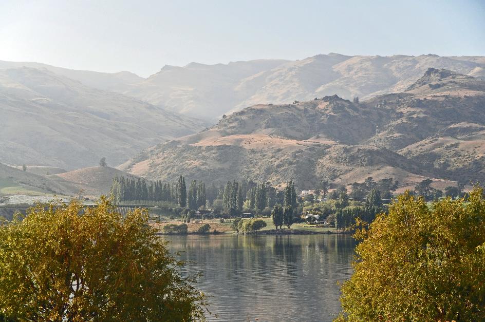
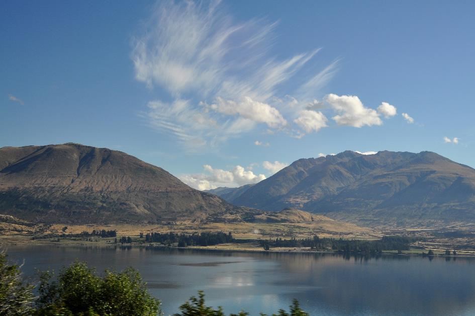
Shortly before five, Lake Wanaka pleasantly surprises us. With the Perfect Reflection of Lake Matheson still fresh in our memory, this glacier lake seems like a reproduction of that mirror lake, but a hundred times enlarged. The blue sky, the white clouds, the barren brown-green mountains, and above all, the ripple-free water surface – everything seems to come together to create the perfect reflection. Some peaks on the opposite side reach heights of over two thousand meters.
The Māori also liked to come here, not to enjoy the picturesque scenery, though. For them, like Lake Matheson, this was an important mahinga kai, a place where they could easily gather food. In the summers, they would appear here to hunt eels and birds. Through the Haast Pass, they ventured higher into the mountains in search of pounamu, the green gold. Then, as autumn approached, they would return to the east coast via the Clutha River in reed boats.
For fourteen kilometres, this picturesque scene is our companion by the window. And that's just one-third of the total length of Lake Wanaka. It is a massive body of water, covering an area of 192 km² – larger than Washington DC – and reaching depths of 300 meters in some places. It's no wonder that you can recognize this region in some scenes from The Lord of the Rings or The Hobbit.
The Neck – Lake Wanaka
And the surprises are not over yet. Neatly parallel to Lake Wanaka, its little sister, Lake Hāwea, emerges a little later, also a remnant from the last ice age. A mountain ridge, five to ten kilometres wide, separates the two glacier lakes. Where this ridge is narrowest – barely a kilometre wide – SH6 hops from one lake to the other. They call this narrow passage The Neck.
Once, this idyllic setting was the backdrop for a bloody episode from the musket wars
The Neck – Lake Hawea
The fact that this idyllic environment was once the backdrop for a bloody episode from the so-called musket wars is hard to grasp. Almost the entire first half of the 19th century, this war plagued the country. Strictly speaking, the English had nothing to do with it. It was, after all, a conflict between the Māori. In practice, however, it was the English who had provided the Māori with firearms. For some tribes, that was the incentive to conquer additional land or settle old feuds, especially if the other tribe did not yet have muskets.
The consequences were disastrous. A veritable arms race ensued, and an estimated three thousand battles were fought over half a century, resulting in a total of twenty to forty thousand war casualties – on an average population of a hundred thousand.
The events here in The Neck took place in 1836. With a hundred-strong force – wars here were never as large-scale as in Europe – the notorious Māori chief Te Puoho crossed the Haast Pass via the West Coast. Just like us, but a bit slower. Here, on this ridge, they encountered a small camp of local Māori. With their traditional weapons of wood and stone, the locals stood no chance. About ten men couldn't escape in time and were taken away as slaves. Two children were killed and eaten on the spot. Since then, the local Māori have never appeared on the shores of Lake Wanaka to catch eels or birds.
Around six o'clock, we reach our hotel in Wanaka, on the shores of the lake of the same name. Paradise shelducks roam through the grass or tumble into the pond in search of food.
It has been a warm, sunny day. We are surprised to find heating appliances and an electric blanket in our rooms.
Wednesday, March 20 | Wanaka - Glenorchy – Queenstown
Wanaka – Lake Wanaka
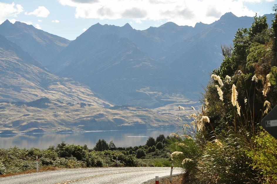
The Māori knew it well; Wanaka is situated at the crossroads of several important routes. In these mountainous, often inaccessible regions, that's no small feat. To the north, there's the Haast Pass, to the west, the entrance to Mount Aspiring National Park, and to the south and east, the valley of the Clutha, New Zealand's second-longest river. Through that valley, we will continue our journey today. And we have beautiful weather ahead.
Dewdrops cast a pale veil over the green grass. Wisps of mist hang low in the flat glacier valley where cows graze. Fluffy sheep clouds adorn the blue sky in the west.
Like a serpent, the Clutha meanders in irregular curves through the wide sediment plain. Just a few centuries ago, these grasslands must have been the favourite habitat of the moa. However, for large flightless birds in this open space, caution was always advised because high in the sky, Haast's eagles were constantly on the lookout.
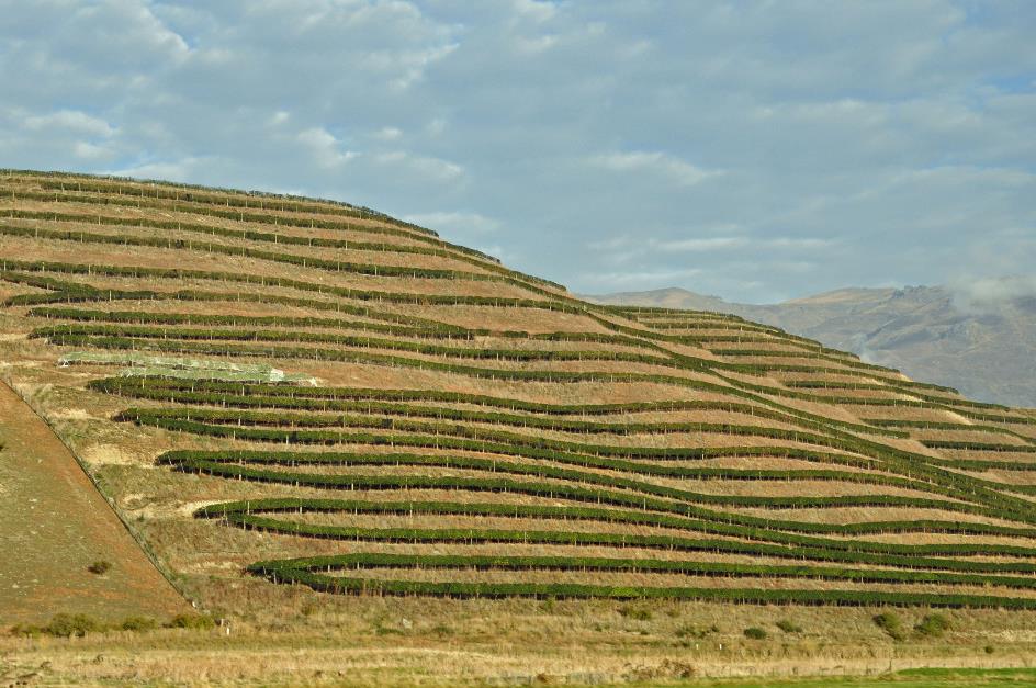
The short summer period is ideal for winemaking, provided that the autumn chill doesn't arrive too early
There are vineyards aplenty here, both in the valley and on the northern slopes. The pinot noir thrives particularly well, but the sauvignon blanc and chardonnay are also quite enjoyable. The fact that you find the southernmost vineyards in the world here is primarily thanks to Central Otago's climate. You could almost call that climate continental. Cold, icy winters are followed by hot, dry summers. Thermometers frequently peak above 30 °C (86 °F) in the summer. Winters can be extremely cold – a temperature of –25.6 °C (–14 °F) was once recorded. Rainfall is scarce because Central Otago is in the rain shadow of the New Zealand Alps. The mountains almost embrace the area like a horseshoe.
In short, the short summer period is ideal for winemaking, provided that the autumn chill doesn't arrive too early. The small windmills in the fields serve as reminders that it can be touch-and-go at times. If frost threatens, these windmills swing into action to generate a mild airflow and prevent frost damage.
Lake Dunstan
Along the road, Lake Dunstan emerges, an elongated, narrow reservoir on the Clutha River. It was formed in 1992 after the completion of the Clyde Dam, about 35 km downstream. Together, the four turbines generate 464 MW.
But the dam faced opposition. A highway had to be rerouted, a railway line had to be abandoned, and, most significantly, 280 houses in the historical city centre of Cromwell would be submerged. On top of that, there were cracks in the rocks due to an earthquake. Despite the controversies, the dam was built.
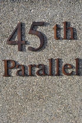
Shifting the 45th Parallel two hundred meters to the north, who cares about that anyway?
If the 45th Parallel crosses through your municipality, it's highly exceptional, they must have thought in Lowburn. Indeed, apart from a part of Patagonia and a piece of New Zealand, this circle only traverses oceans on the southern hemisphere.
That the 45th Parallel, unlike the tropics and the polar circles, has no astronomical or climatological significance is temporarily irrelevant. The point is that you are exactly as far from the equator as you are from the South Pole. Even that is not entirely accurate due to the Earth's curvature, with the South Pole still about five kilometres farther than the equator. But that's beside the point.
You have to flaunt that 45th Parallel, and that's that. So, a nice marker along SH6 with a parking lot and some information boards, allowing every passer-by to pause and contemplate their place in the universe. Unfortunately, there wasn't enough space for a parking lot at the designated location. No problem, a solution was found. Two hundred and twenty meters to the north, there is enough space for a parking lot. So, you just move your marker a bit. Who cares?
45th Parallel |
|
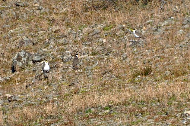
Masked lapwings |
High on the slope on the opposite side of the road, a few masked lapwings keep an eye on us. Even at this distance, they are easily recognizable with their distinctive yellow masks around their eyes. They probably have their nest up there in the low grass between the rocks because they love open spaces. They prefer to stay on the ground, scanning for insects and worms.
Despite their elegant appearance, these beautiful birds pose a real threat to aviation. They like to nest in the low grass around runways. Once they've staked out their territory there, it's nearly impossible to move them. About ten strikes are reported every year.
The Māori found a place where the turbulent Clutha River is so narrow that you can cross it on foot
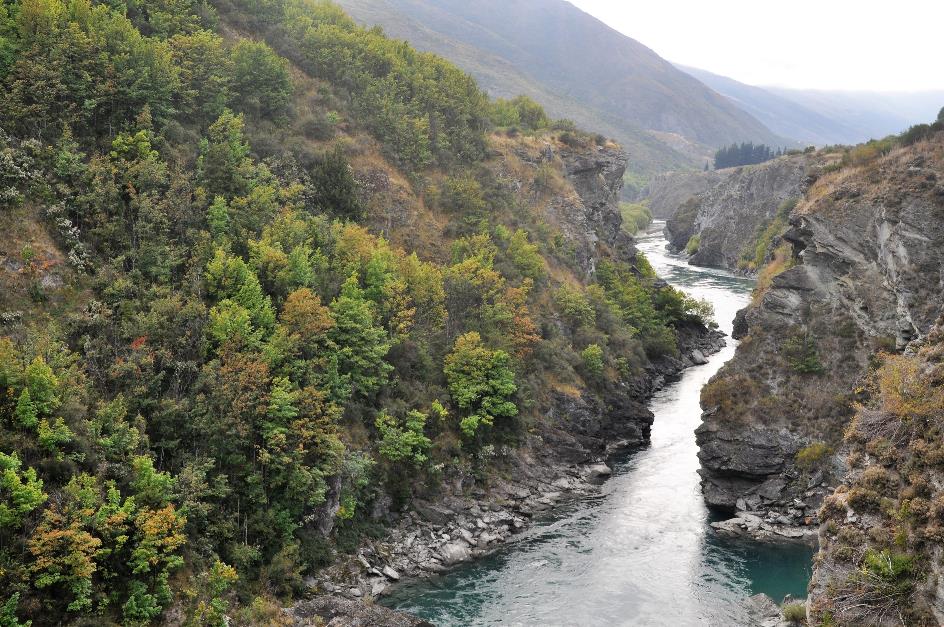
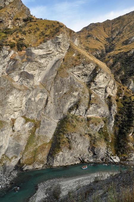
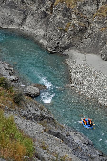
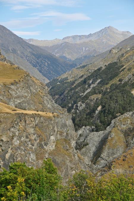
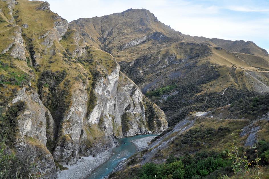
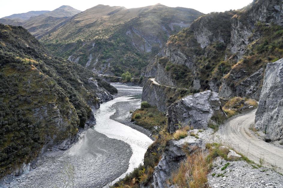
Kawarau Gorge
Just beyond Cromwell, we descend into the steep Kawarau Gorge. This tributary of the Clutha River will guide us to Frankton and Queenstown. It's a wild river, very popular among white-water enthusiasts. It can be dangerous too, with rafting being completely prohibited in some sections.
The Māori also had to deal with this wild, turbulent river. Along with the wide Clutha, it blocks the way to the north. However, they found a place where the river is so narrow that you can cross it on foot. They call this place Whatatorere, along SH6, a little beyond Roaring Meg. This rock bridge must have been in use for six hundred years. Even gold prospectors gladly used it.
Reminders of gold prospectors are evident in the primitive wooden houses on the other side of the river. This valley, too, was in the grip of gold fever in the 19th century, as evidenced by the presence of eglantine bushes along the road. This exotic plant was imported by European settlers. Rosehip tea must have been one of the few luxuries they could indulge in here.
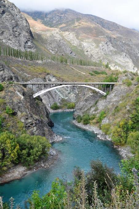
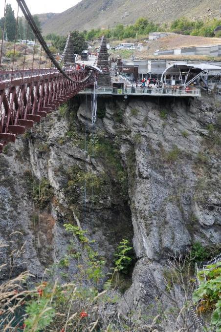
Nowadays, indulgences in this area are of a completely different nature. Just before ten, we reach the Kawarau Gorge Suspension Bridge. This is the mecca of bungee jumping. Not because it's the highest bungee jump in the world or because the first jump in history took place here. Rather, it's because a man named Alan John Hackett operated the very first commercial bungee jumping installation here.
That elastic around our ankles? No way
Bridge over Kawarau River |
|
Kawarau Gorge Suspension Bridge – Origin of commercial bungee jumping |
His inspiration came from Pentecost, one of the islands of Vanuatu, where young men prove their manhood by jumping off a high wooden platform. Two vines tied to their ankles theoretically prevent them from falling to their death. AJ, as he is affectionately called in New Zealand, built a multimillion-dollar business around that ancient initiation ritual, showcasing much ingenuity and determination.
Today, you can still send adrenaline rushing through your veins by jumping about forty meters deep from the suspension bridge. The impressive Kawarau Bungy Centre has been developed around this experience. According to the operators, it's a must-visit. They equate skipping this place to visiting Paris without glimpsing the Eiffel Tower. Taking a look is one thing, but that elastic around our ankles? No way.
Arrowtown – Street scene |
|
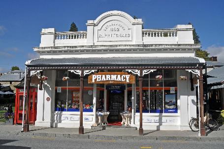
Old Pharmacy |
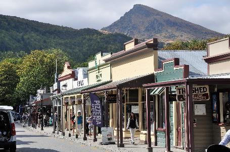
It's much quieter in Arrowtown, a historic mining town with three thousand inhabitants. Before 1862, this place didn't even exist. A few years later, there were more than seven thousand people around. That's because kilos of gold were found in the Arrow.
Arrow River
The town has managed to preserve its historical atmosphere quite well. Strict regulations from the municipal government have contributed to this. The town did well out of it. Tourists flock to it, if only to stroll through the remnants of the Chinese settlement.
It must be that the chimpanzees weren't interested because only the Chinese responded to the invitation
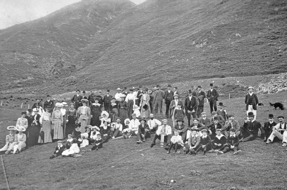
That the peak of the gold rush seemed to be behind by 1865 was a cause for concern for the Otago government at the time. The nascent economy in the newly developed areas could collapse. Any form of population increase – even if they were chimpanzees – is preferable to having no population at all, wrote a local newspaper. It must be that the chimpanzees weren't interested because only the Chinese responded to the invitation.
In the end, about eight thousand Chinese arrived in New Zealand to try their luck from 1869 onwards. That must have been quite a shock for them – from the subtropical environment of Canton (present-day Guangzhou) in southern China to the almost continental winters of Central Otago.
Soon, one in six gold prospectors in Arrowtown was Chinese. Earning a hundred to two hundred dollars in a few years was their business plan. That amount was enough to return to China, buy a farm, and henceforth provide for their own needs. Or, in other words, to escape poverty and famine. In principle, they could achieve this in five years. But for many, that proved too ambitious.
Resentment, envy, and racism increased rapidly
Arrowtown – Homes of the Chinese Community
Initially, it wasn't so bad. The first Chinese were welcomed with an open mind. Soon, they managed to find gold, even in sections that had already been explored and abandoned by European gold miners – to the great surprise of everyone. A local newspaper praised their self-control, thriftiness, and good behaviour.
As more and more Chinese arrived and less gold was found, the tide turned. Resentment, envy, and racism increased. A local newspaper referred to dirty Chinamen with almond-shaped eyes and leprosy-affected skin. An inferior race was trying to take control of New Zealand, it was said – where did we hear that before. The government responded with stricter immigration laws. In 1898, Chinese were explicitly excluded from the national pension law.
The fact that there was hardly any physical violence during all this time seems to indicate that the Chinese let the whole commotion pass over them. In 1932, Ah Gum died, and with him, the last survivor of this small Chinese community.
Chinese dwelling |
|
|
A path leads us along the main remains of the old settlement. Simple huts they are, built by the Chinese themselves with limited means, sometimes sheltered by a rock wall of slate. Behind some huts, well-kept gardens must have stretched out, as shown in archival photos. That came in handy once the gold supply was depleted. Because now they could make a living by selling those vegetables. Not all Chinese, however, succeeded in returning to their homeland. One in seven died in New Zealand.
Chinese dwellings |
|
|
That was an additional complication, as Chinese people prefer to be buried in the ancestral graveyard. No expense was spared to repatriate bodies, sometimes with tragic consequences. In 1902, a ship carrying nearly 500 bodies sank off the coast of New Zealand.
If you needed an interpreter or had to write a letter in English, Ah Lum was your man
House of Ah Lum – Shop, bank and guest room
The highlight of the estate is Ah Lum's shop. It was completely restored in 1986 and was the heart of the settlement. You could buy European products there, as well as Chinese items such as tea, rice, ginger, and even opium. The shop also offered banking services, including small loans. If you needed an interpreter or had to write a letter in English, Ah Lum was your man. He spoke fluent Chinese and English. You could even spend the night in a tiny guest room.
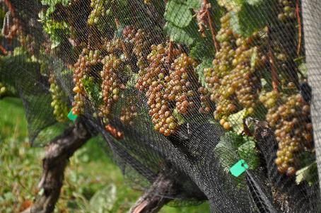
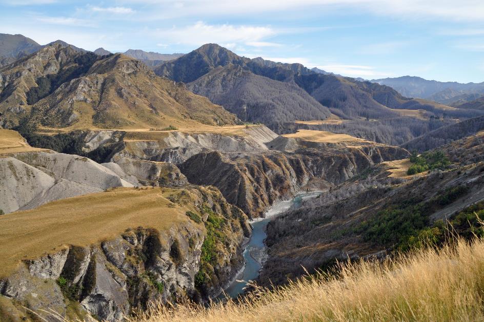
We have now left the Kawarau Gorge behind us. Continuing through the Wakatipu Basin, this is a relatively flat area, a vast open space surrounded on all sides by inaccessible mountains ranging from fifteen hundred to two thousand meters. It's the perfect place for farmers to showcase grasslands, fields, and, of course, vineyards amid this rugged landscape.
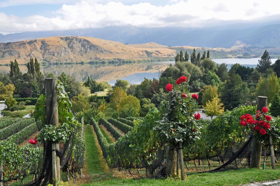
Vineyards of Stoneridge Estate, Lake Hayes
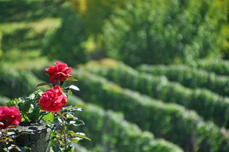
One of those wineries is Stoneridge Estate. From the northern slopes of Morven Hill, the vineyard overlooks the small Lake Hayes. We climb on foot through the well-kept vineyards. Almost ripe bunches of grapes hang from the vines, waiting to be harvested. Fine-mesh nets shield the grapes because humans are not the only ones who fancy these juicy fruits.
Red roses bloom at both ends of each row. They serve well as decoration, but that is only a side effect. In these vineyards, they play the same role as canaries in a coal mine. If there is a disease affecting the grapevines, the rose petals will be the first to be affected, allowing the winemaker to intervene in time.
In these vineyards, they play the same role as canaries in a coal mine
|
|
|
The higher we climb, the more breathtaking the landscape becomes. With the sun fully present, the scenery is bathed in a kaleidoscope of all possible shades of green, blue, and pale brown. The ripple-free reflections in the lake enhance that effect. On the other side, the clouds gradually release their grip on the mountains, eventually revealing the Coronet Peak, a popular ski resort.
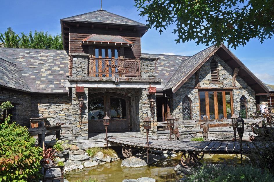
Stoneridge Lodge
Authenticity and rustic charm were the norm when the winemaker began building Stoneridge Lodge. Hardwood beams, natural stone, slate, and wrought iron played the lead roles. Antique artefacts found their decorative places here and there. So, on your way to the bathroom, you might encounter an oversized knight's armour. Opinions on the result of all this may vary, unless high fantasy is your thing, of course.
It's not elves welcoming us here, but two flesh-and-blood ladies. Giselle handles the reception, while Nathalie reveals the intricacies of the wines we will be tasting during lunch – a white pinot gris, a rosé, and a red pinot noir.
It's half past one when we arrive at the shores of Lake Wakatipu near Frankton. Its shape on the map bears a striking resemblance to a lightning bolt. This is New Zealand's third-largest lake, stretching over eighty-four kilometres. It even reaches below sea level, as it is 380 meters deep, while the shores are only 310 meters above sea level.
What was a piece of cake for us was a challenging feat for the early colonists. Only in 1853 did Nathaniel Chalmers become the first to reach this lake, thanks to a Māori chief who knew the way. But since then, pioneers have made this fascinating environment accessible. Meanwhile, it has grown into a place of world fame, attracting visitors from all over the globe – Queenstown counted as many as 2.7 million visitors in 2013.
The Adventure Capital of the World, that's how they describe themselves in Queenstown, also known as the adrenaline capital of the world. Adventure tourism is the name of the game here. If you can't experience it in Queenstown, it's probably not worth doing. Reportedly, they offer more than two hundred activities, including – just to name a few – luging, skateboarding, mountain biking, trekking, horseback riding, bungee jumping, giant swings, catapults, zip-lining, rock climbing, canyoning, skydiving, gliding, paragliding, parasailing, water skiing, jet skiing, jet boating, kayaking, rafting, river water surfing, white-water sledging, gliding, ballooning, snowboarding, skiing, ...
If you can't experience it in Queenstown, it's probably not worth doing
But for now, we leave this fascinating city untouched, as we are on our way to Glenorchy. However, we can't ignore the long queue for Fergburger in Shotover Street. They've made a trademark of giant burgers with a gourmet label. To such an extent that the place itself has become a tourist attraction. Open from eight in the morning until... five in the morning.
Aotearoa, land of the long white cloud
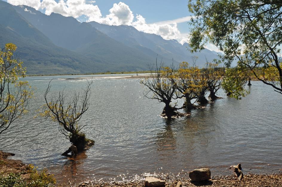
It's a beautiful piece of New Zealand unfolding outside the window now. The winding path along the steep shore of Lake Wakatipu surprises us with one stunning view after another. This brings us to the tranquil Glenorchy – a world of difference from the bustling Queenstown. We plan to take a one-hour stroll around Glenorchy Lagoon.
A bit further north lies the tiny Paradise, no more than a pocket handkerchief in size. It was here that Top of the Lake unfolded, the BBC series that captured the oppressive atmosphere of an isolated community so well. Peter Jackson also had a fondness for this place. In this vicinity, he situated Lothlórien, one of the realms of Middle-earth in The Lord of the Rings.
Lake Wakatipu
Remembrance of the fallen from World War I and II takes place in many New Zealand communities, including Glenorchy. However, here, they have turned the memorial into more than just a soldier statue. A brief life story is outlined for each individual involved.
Take, for example, Thomas George, a simple shepherd from Glenorchy. As a twenty-year-old volunteer, he left New Zealand on April 1, 1916, to fight on the other side of the world. He survived the Battle of the Somme in France, but the Battle of Passchendaele in Belgium proved fatal. The last anyone saw of Thomas was him returning wounded from the battlefield, seeking medical help.
He survived the Battle of the Somme, but the Battle of Passchendaele proved fatal
An inscription on the Tyne Cot Memorial in Zonnebeke, Belgium, is the only reminder of him. In a special apse, the names of nearly twelve hundred New Zealand soldiers who fell in the Ypres Salient and have no known grave are engraved. What makes his story even more poignant is the fact that Thomas had been sentenced to death for desertion just four days before his death. He had not returned from leave on time. All indications suggest that he suffered from shell shock – a condition not recognized or treated at the time – and was sent back to the front despite this.
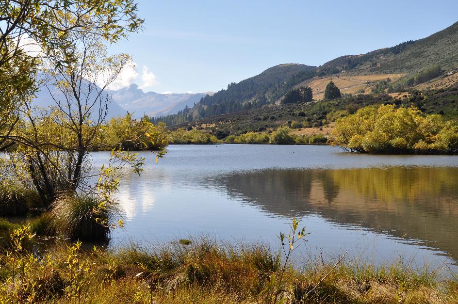
Glenorchy Lagoon
All the ingredients are present to make the flat walk around Glenorchy Lagoon a gem. Most of the time, it's gravel, sometimes boardwalks, but as always, it's an excellent trail. The sun shines in the blue sky, the picturesque lagoon is almost ripple-free, and on the mountain slopes, shades of ochre, pink, and brown announce the upcoming autumn. It's even quite warm in the open space under the blazing sun.
Mount Alfred |
|
|
In the distance, the conical silhouette of Mount Alfred attracts attention. It looks like a little volcano, but it's not.
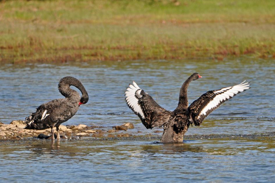
Once again, black swans are the most striking presence on the water
Once again, black swans are the most striking presence on the water. They glide pompously over the calm water surface, aware of their own dignity. Then, suddenly, they throw all decency overboard and reveal their least attractive body part while diving underwater for food.
Suddenly, a bird of prey soars over our heads. Open spaces like the ones around the lagoon are the favourites of this swamp harrier. Exactly that turned out to be its luck. Because these harriers were among the few birds that benefited from the arrival of the colonists. As loggers cleared more and more forests, the open space became larger and larger.
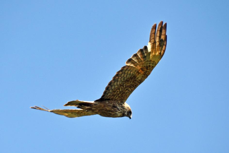
Swamp harrier
It's likely that this swamp harrier has built its nest somewhere between the reeds or on a dry mound in the marsh. In summer, it feeds on birds, rabbits, and other small mammals. In winter, on the other hand, it mainly scavenges carrion, often carcasses of animals killed on the road by cars. That can sometimes cost it dearly, as it risks losing its life in the process.
The call of the New Zealand bellbird has even made it as a tune on Radio New Zealand
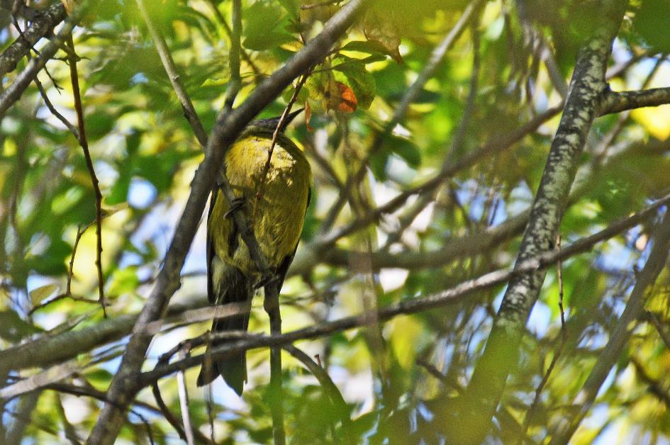
New Zealand bellbird
Vivaciously, an olive-green bird flutters back and forth high in a tree. It's barely distinguishable among the dense foliage. Captain Cook once described the beautiful sounds produced by this bird as small bells perfectly tuned to each other. Hence, the colonists named it the bellbird. Its call has even become a tune on Radio New Zealand since then.
We refer to this endemic honeyeater as the New Zealand bellbird. With the brush-like tip of its tongue, it can easily slurp up nectar and honeydew. Many native plants rely on it for their pollination. However, the arrival of the colonists has also affected this bellbird. The loss of native forests led to the disappearance of its habitat. Voracious rats, stoats, and the like made its life difficult. Some exotic species even went so far as to steal honey right under its nose.
Glenorchy Wharf – Dart River
Via Lake Road, we stroll over the bank of the Rees River to Glenorchy Wharf. In the soft evening sun, it is also a pleasant place for the locals to linger.
Lake Wakatipu
In Queenstown, on the shore of Lake Wakatipu, we find our place for the next two nights.
Thursday, March 21 | Queenstown – Skippers Canyon
Every half-hour, the water level of Lake Wakatipu rises and falls by twelve centimetres, day in, day out. Do we know why? No, no one knows. Except the Māori.
Speaking is Brynt, one of the drivers of the two Toyota 4WD vans from Queenstown Heritage Tours that we set out with just before half past eight. The fifty-year-old has turned into a delightful stream of speech. Passionately, he tells his story, here and there coloured with a healthy mix of humour and exaggeration.
On this first day of autumn, we are on our way to Skippers Canyon. We are well aware that gold fever gripped this island in the 1860s. But nowhere did it reach such hallucinatory proportions as in Skippers Canyon, on the banks of the Shotover River.
We will penetrate more than twenty kilometres into that gorge. In our wake, the second van follows, with Wolfgang at the wheel. Or Wolfie, as he likes to call himself. Or the mad German, as Brynt likes to call him. Because soon his daredevil antics will frighten and annoy us.
Nowhere in New Zealand did gold fever reach such hallucinatory proportions as in Skippers Canyon
But what about the water in the lake? Well, a long time ago, Manata lived here, the beautiful daughter of a local Māori chief, Brynt continues his story. Matakauri was her great love, but her father had a low opinion of that young man.
Until one day Matau showed up, a monster living in the mountains. He fancied the beautiful Manata and kidnapped her. The chief liked that even less. Whoever could bring back his daughter could marry her, he said.
Matakauri saw his chance and went into the mountains, looking for the monster. With a trick, he managed to outsmart the malevolent creature and reduce it to ashes in a gigantic fire.
Thus, a giant pit was created. Due to the heat, the snow on the surrounding mountains melted, filling the pit with water. Lake Wakatipu came into being. Because if you look closely at the map, you can easily recognize the shape of the monster in the form of the lake. It must have lain on its left side, with its head at the level of Glenorchy and its raised knees at the level of Queenstown.
And that is also the explanation for the strange behaviour of the lake. Because the monster is still not dead, according to the Māori. The rising and falling of the water is caused by its beating heart.
The Māori knew that yellow gold could be found in Skippers Canyon, but they didn't attach importance to it
Meanwhile, we have left Lake Wakatipu behind. Every time the Māori appeared on the shores of this glacier lake, they did not stay long, Brynt says. Because they were passing through to the west coast, in search of pounamu, the green gold. They knew there was yellow gold to be found in Skippers Canyon, but they didn't care about that. After all, they did not know any techniques for processing gold.
Europeans had to wait until the second half of the 19th century to arrive in this region. William Rees and Nicholas Von Tunzelmann were the first to settle here in 1860. Little did they know they had settled in the heart of what would soon become Otago's largest gold mine.
They let fate decide who would settle where. In hindsight, it was Rees who hit the jackpot. He could build his future in the place where bustling Queenstown now stands. Von Tunzelmann, on the other hand, allowed himself to be banished to a lonely place on the other side of the lake, at the foot of Mount Nicholas.
Not long after, in August 1862, a certain Jack Tewa found the first gold in the Arrow River. As soon as Rees heard the news, he wanted to keep it secret at all costs because he couldn't afford to lose a man when the sheep had to be sheared. But the cat was out of the bag. Two men slipped away, Thomas Arthur and Harry Redfern. Where the Shotover flows into the Kawarau, they managed to collect 280 grams of gold – equivalent to 10,350 euros in today's currency.
I don't need to explain who Edith Cavell is to Belgians, Brynt guesses correctly
Meanwhile we reach Arthurs Point, a small settlement in a U-bend of the Shotover, named after Thomas Arthur. I don't need to explain who Edith Cavell is to Belgians, Brynt guesses correctly. She was a widely praised British nurse who cared for wounded soldiers in the Brussels suburb of Ixelles during the First World War, regardless of their nationality – Belgian, French, English, German. She secretly organized escape routes, but only for the Allies. She paid the ultimate price for that because the Germans found out. They executed her on October 12, 1915, at the National Shooting Range in the Brussels suburb of Schaerbeek.
So, it's a surprise for us when the bridge over the Shotover turns out to be called the Edith Cavell Bridge. This is the result of the personal crusade of a local gold prospector, Jack Clark. He insisted for years on renaming the bridge after the nurse. However, the government refused to budge. So Clark took matters into his own hands and painted Edith Cavell Bridge in large letters on the structure. Meanwhile, the letters have faded, but the name remains. It has become entrenched in the collective memory of the local community.
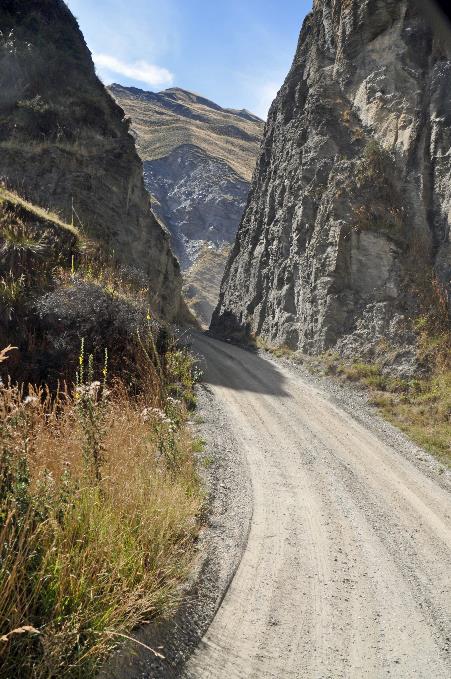
At the mouth of the Shotover, where Arthur and co found their first gold, gold mining quickly came to an end. Searching further upstream was the only option. But that was not easy. Because even the boldest had to admit that entering Skippers Canyon was not a walk in the park.
And then you have to consider, Brynt adds, that these men came on foot all the way from the east coast – a journey that takes about 3½ hours by car. Only then did they have to deal with Skippers Canyon, by far the most difficult and dangerous stretch.
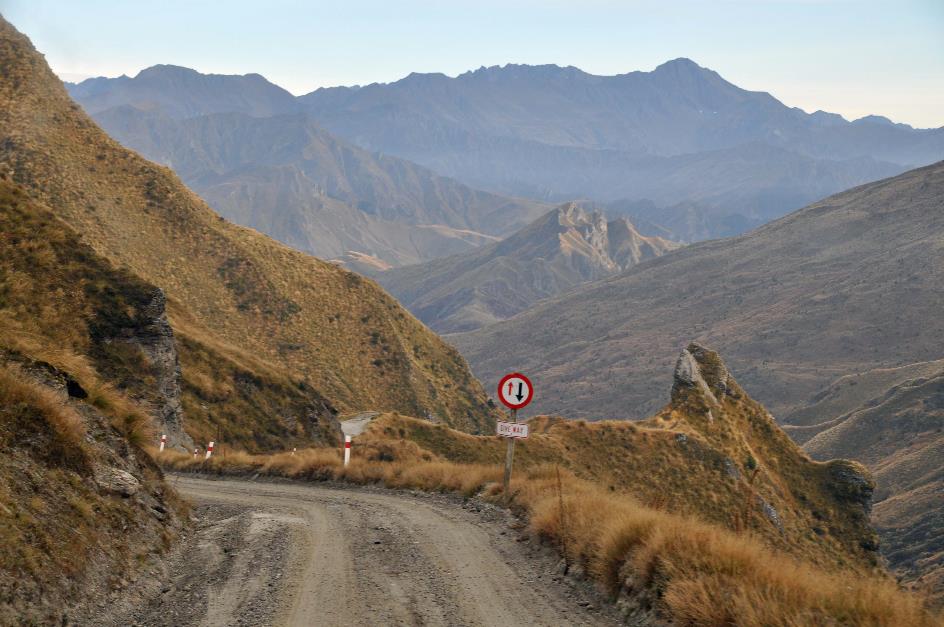
Skippers Saddle – Cloud cover over Kawarau Valley
On the left, we cast a final glance at the blanket of clouds stretching over the valley, resembling a sea of white clouds gently lapping against the mountains. Shortly after, the unpaved road takes us over Skippers Saddle, standing at 940 meters, the highest point of the journey. The descent into Skippers Canyon can now commence. However, for gold prospectors, this pass was too challenging. They opted for the opposite bank, where a narrow bridle path guided them across the steep slopes.
Summer and winter, Julien Bourdeau succeeded in supplying the settlements in the canyon
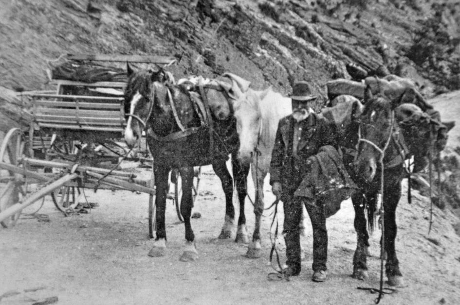
Julien Bourdeau with his packhorses
Countless times, Julien Bourdeau must have passed through here with his two packhorses. Twice a week, he made his two-day round trip between Queenstown and Skippers. Summer and winter, he managed to supply the settlements in the canyon – if necessary, he equipped his horses with shoes with iron spikes to plough through mud and snow. He kept up this routine for more than fifty years until his death in 1916 at the age of 87.
|
|
Lighthouse Rock |
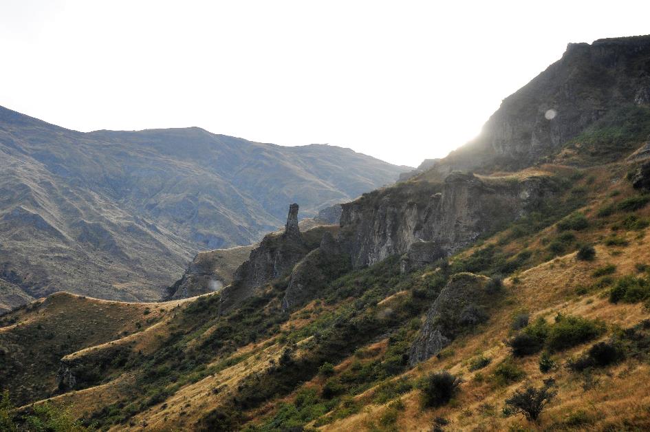
Skippers Canyon
Now it goes steeply downhill, one bend after another. Guardrails are nonexistent. On the left, the slope of Mount Dewar rises almost vertically, on the right, the abyss beckons. Crossings with other vehicles are impossible on this narrow, unpaved road. That doesn't matter at all, Brynt counters our concerns. Anyone venturing onto this road should know that around this time of day, you only drive downhill. And in a few hours, you should only drive uphill, it's that simple. Only tourists in rental cars sometimes don't understand that, he adds. Such tourists shouldn't be here at all, it flashes through our minds, as no rental car insurance covers this route.
Skippers Canyon – Lighthouse Rock
Like a lighthouse, a rocky formation emerges from the mountainside. That's Lighthouse Rock, and it couldn't have gotten a better name. Brynt introduces us to it, along with the stunning surroundings. In the distance, he points out Mount Aurum. The name says it all – that's the culprit, the mountain that is the source of all the gold that gold prospectors moved heaven and earth for.
All in all, the cold was probably the biggest enemy of the gold prospectors
In winter, it can get extremely cold here, down to –16 °C to –17 °C (3 °F to 1 °F). All in all, that cold was probably the biggest enemy of the gold prospectors. It must have been quite an operation to transport the necessary firewood and especially that 45 kg cast-iron stove over this route.
Rising sun above Lighthouse Rock
Scurvy was also a formidable threat. Tea made from the flowers of a particular bush helped against it. If fresh meat started to smell after a few days, they added parts of a certain plant to it. That dispelled the stench, but not the bacteria.
On the steep slope across the valley, you can easily recognize the original path of the gold prospectors, essentially nothing more than a narrow donkey trail. Nowadays, they call it Skippers Pack Track. It's quite popular among mountain bikers. They zoom down it at breakneck speed. Brynt can attest to it; his son is one of those enthusiasts.
Older Douglas firs underwent a precision bombing of poison from helicopters
Green trees are no longer present on that slope. What remains are the reddish remnants of Douglas firs. They are an invasive species of exotics that have displaced the native vegetation. Once, these extremely tall trees were highly valued – in their homeland on the North American coast, they could reach a height of a hundred meters. But now, they are no longer welcome. They were sprayed with poison thirteen years ago. Hopefully, they will soon fall apart from misery, Brynt chuckles.
That the Kiwis didn't rush into things is evident. With GPS measurements and maps, they first carefully mapped out the vegetation. Older Douglas firs underwent a precision bombing of poison from helicopters. Endemic species were spared as much as possible in this way. Young firs, on the other hand, were cut just below the green. To do this, volunteers were dropped off with helicopters on the slopes.
All these mountains around us have formed because Australia pushes up the west coast of New Zealand a few centimetres each year. Well, sighs Brynt, in that regard, the Aussies are stronger than the Kiwis. But in rugby, it's still the All Blacks who are the strongest at pushing, he proudly grins.
As we continue to roll down the slope of Castle Rock, Brynt stimulates our imagination. In a particular rock formation, he claims one can recognize a gorilla and an elephant. A gorilla, we can manage, but an elephant? It lies stretched out with its legs in the air – a Down Under elephant, Brynt grins.
A bit cynical perhaps, a hotel with the name Welcome Home Hotel in such an inhospitable environment
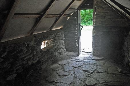
Two chimneys and a few foundations are all that remain of the Welcome Home Hotel in the Long Gully. Perhaps a bit cynical to have such a name in such an inhospitable environment. But it must be said, gold miners, shepherds, and even tourists felt at home there. Originally, the building stood next to the donkey path on the other side of the valley. Only when a road was built on this side did it move here. From 1908 to 1942, it served as a hotel, a transport company, and a post office. However, it did not go without calamity. In 1930, it had to be completely rebuilt after a severe fire.
In the early forties, interest began to wane. Except for a few stubborn ones, all gold miners had left Skippers Canyon. The hotel was no longer profitable and was demolished to the ground. The materials were used for a new building on the shore of Lake Hayes, more than twenty kilometres away. The fact that they went to the trouble of hauling it so far across this terrain speaks volumes about the value of building materials in this remote area.
The same goes for the gold miners. When they moved away, they took everything with them. Literally, they left nothing behind in the place where they stayed. Yet, you can often still easily recognize those spots in the landscape. Because they had planted poplars there to quickly have dry wood for their stoves.
From Pinchers Bluff, we gaze over a U-bend of the Shotover
A short climb takes us to the edge of a narrow, deep gorge. Finally, there it is – the notorious Shotover River. The cliffs slope almost vertically down to the azure-blue water that rushes by nearly a hundred meters below. Impressive, mostly bare mountains rise on the other side, towering more than a thousand meters high.
|
|
|
Shotover River – Rafting
Often, the gold prospectors would sleep down there on the riverbank. A highly dangerous practice, as during the night, the water level could rise by up to six meters. The azure-blue river would then transform into a dark-grey deluge, sweeping away everything in its path.
Peter Jackson understood this very well when he came here to film the turbulent river that, in the first part of The Lord of the Rings, washes away the Black Riders. Upstream, he had a dam built, and down on the pebble beaches, he set up his cameras. Once the dam was opened, the cameras captured the deluge coming through the canyon. Later, the Black Riders were edited into the footage, fleeing ahead of the water.
In Skippers Canyon, the proverbial lone eccentric cannot be missing. His name is Dave, and he lives secluded in a small house among the trees on the edge of the gorge. Technically, you're not supposed to live in this nature reserve, but nobody bothers him. His car doesn't even have a license plate, but nobody cares about that either. Dave is even a bit spoiled, Brynt mentions, as Wolfie regularly leave a recent newspaper under a stone near his home as a friendly gesture.
Shotover Valley
From Pinchers Bluff, we gaze over a U-bend in the Shotover. White foam indicates small rapids in the azure-blue water. Rafters have their hands full navigating through without mishaps. One of their Zodiacs unintentionally performs a 360° pirouette.
For schoolchildren, this is a regular activity. For years, they've been coming here to learn survival techniques. Armed with a week's worth of provisions, they venture into the wilderness. Kayaking, rafting, abseiling, crossing fast-flowing rivers – it's all part of the school curriculum in New Zealand, according to Brynt. Moreover, there hasn't been a single accident in the past 35 years. And there's even reception for their smartphones. Unfortunately, no charging stations, he grins.
Occasionally, there were deaths, but the contractor didn't mind – they were just Chinese
Shotover Valley
The landscape around us becomes increasingly impressive. Carving a road into this rock wall was no easy task. It happened in phases, from top to bottom. Men were lowered in baskets to place explosives. Layers were blown away one by one until the correct level was reached. Occasionally, there were deaths, but the contractor didn't mind – they were just Chinese.
The valley widens a bit now. Over the millennia, the Shotover River has carved a deep trench through the thick sediment. On the treeless terraces on either side, dry, pale grass grows. Above all, the tireless autumn sun shines.
Shotover Valley – Excavated terraces
Initially, individual gold prospectors came here in search of their fortune. Armed with shovels and gold pans, they worked in the mud around the river, searching for alluvial gold. These are minuscule gold nuggets, sometimes no larger than a pinhead. Due to water erosion, these nuggets broke free from quartz veins in the schist rock higher up in the mountains. Patiently sifting was the motto, day in and day out, until something shiny lay in the mud.
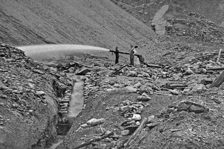
However, over time, the gold prospectors realized that the river must have also deposited gold in the terraces. This required a completely different approach. The soil had to be excavated or, even better, washed away with powerful water jets and then sifted.
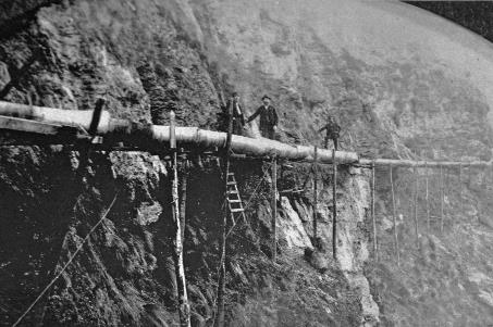
Water supply through pipes |
|
Washing away soil with powerful water jets |
This couldn't be done alone; you needed a company for that. After all, you had to establish a constant water supply with high capacity. Pipelines and pumps needed to be installed and maintained. Complex sieve systems, such as sluice boxes, had to replace primitive gold pans. Naturally, a village emerged around all this activity.
From Māori Point Saddle, we get a good view of this. Two hundred meters below, the Shotover River struggles through a narrow gorge. It was there that Raniera Erihana made the first gold discovery in this valley in November 1862. A record discovery, no less – 9.33 kg. Nowadays, you would get 345,000 euros for that.
Gold prospector
And the gold prospector had his dog to thank for that. Because the dog had unexpectedly ended up in the swirling water. In an attempt to save the animal, Raniera suddenly saw gold sparkling between the rock crevices. Since he was Māori, the place has been called Māori Point ever since. It's immediately clear that the Māori had somewhat adjusted their views on the yellow gold in the meantime.
Stony Creek |
|
|
The steep V-shaped valley on the opposite side is Stony Creek, the only place in the valley where the Chinese were allowed to search for gold. The Europeans themselves avoided that gorge like the plague because it was far too dangerous. With the slightest rainfall, there was a risk of drowning.
V-shaped grooves, half a kilometre long and fifteen to twenty meters deep, draw grey scars through the pale grass
Shotover Valley – Excavated terraces
But it is mainly the excavated terraces on the opposite side that fascinate us. V-shaped grooves, half a kilometre long and fifteen to twenty meters deep, draw grey scars through the pale grass. They testify to the brutality with which the terraces were tackled. However, there is no trace of the perpetrators anywhere. They disappeared without a trace, taking all their belongings with them.
Strange, very strange. Because at the height of the gold rush, this was its epicentre. In September 1863, there were shops, bakeries, butchers, a library, a police station, a courthouse, and of course, a gold office of the Bank of New Zealand. Later, six more hotels would be added. Charlestown had two thousand inhabitants then, more than in the then-existing Queenstown. But today, there is literally nothing left to see.
If you wanted to cross the Shotover in the early Charlestown, you would sit in a hollowed-out log. Ropes made of oxhide would then pull you across the fast-flowing river. It didn't take long before a bridge came in December 1863. There wasn't much use for it. Heavily loaded packhorses couldn't even cross it because it was so narrow. Unloading your horse first and then carrying the load to the other side was the only option.
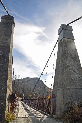
Almost forty years later, the gold lobby finally got its way. Between 1898 and 1901, the government built a real suspension bridge at this remote location. It became a masterpiece, 91.4 meters above the river – the country's highest suspension bridge. Notably with towers of reinforced concrete at both ends. That had never been seen before.
|
|
|
It became a masterpiece – the country's highest suspension bridge
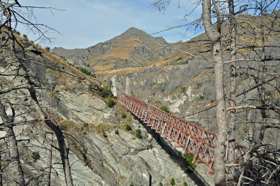
Skippers Canyon Suspension Bridge
The gold lobby could rejoice. No more laborious searching for alluvial gold; henceforth, they could explore the quartz veins in the rocks. Because they needed heavy machinery capable of pulverizing rocks, the new bridge allowed them to bring in such machines. Who knows how rich those quartz veins were. Unfortunately, despite all efforts, the anticipated profits were never realized.
Before reaching the bridge, we must first cross the Blue Slip. A dangerous stretch of road, mutters Brynt. How so, dangerous? Isn't the chilling route we've just covered dangerous, perhaps? Oh no, he shrugs, it's only dangerously slippery when it rains. Here, it's always dangerously slippery because the loose slate can slide.
Shortly thereafter, the towers of Skippers Canyon Suspension Bridge come into view. Vehicles weighing a maximum of three tons with no more than one and a half tons per axle are allowed to cross. No problem for our Toyota with nine occupants. On foot, we stroll across the bridge, taking in the impressive surroundings.
Bridges are designed to reach the other side of a river. At least, that's what most mortals think. But not AJ Hackett
Bridges are designed to reach the other side of a river. At least, that's what most mortals think. But not AJ Hackett. Just after introducing bungee jumping on the Kawarau Bridge, he sought more adrenaline. That's when Skippers Canyon Bridge came into play. Because, let's face it, a depth of 91.4 meters is more than double the 43 meters above the Kawarau.
This didn't sit well with a certain Jerry Hohneck. Downstream, he offered tourists a spectacular jet ski tour on the river. He reluctantly watched as tourists on their way to AJ's bungee bridge ignored his attraction.
He quickly came with a solution. Thanks to the gold miners and their water pipelines. It turned out that one of those pipelines crossed the Shotover just above his domain, notably at a height of 102 meters above the water. So Hohneck developed his own bungee offering – higher than AJ's and even closer to Queenstown.
Of course, that led to legal issues. The matter was settled amicably when AJ took over Hohneck’s business. However, both bungee sites have long been closed. Because in his quest for ever more adrenaline, AJ found a jump of 240 meters. They're lunatics, Brynt concludes, shaking his head.
Deeper in the valley lies Branches Station. They have twenty thousand merino sheep there, plus thousands of cattle. Once these animals are ready for slaughter, they have to be driven to Queenstown, more than thirty kilometres away. This is done entirely via this dangerous road, often no wider than 2.2 meters. It must result in hallucinatory scenes. Hundreds of cows on the Blue Slip, we try to imagine it.
But we turn left, heading towards the remarkably green surroundings of Skippers Point. The highlights here are the school building and a cemetery. That's much more than in Charlestown. The school building has even been renovated and is in excellent condition. It was in use from 1879 to 1927.
Skippers Point – Former school building
Skippers Point was never a typical mining town, although at its peak, the settlement had around a thousand residents. Instead, it served as a hub for miners who had settled in various places in the vicinity with their families. The area boasted some houses, a hotel, a library, a community hall, a school, and a cemetery. Julien Bourdeau also had a store there.
Skippers Point was never a typical mining town, although at its peak, the settlement had around a thousand residents
Only a church building was missing. Anglicans, Presbyterians, and the Salvation Army held their services in the hall, while the smaller group of Catholics gathered in one of the residences. Ministers travelled on horseback to this remote corner to conduct their services and stayed overnight with one of the residents.
Then, just after eleven, we began our return. Where Jerry Hohneck launches his jet skis, we descend to a pebble beach. On a calm day like today, eight cubic meters of water flow through the Shotover every second. In 1999, the flow rate quickly swelled to 945 m³/s. More than a hundred times the normal amount. The water level then reached several meters above our heads.
Brynt never lacks anecdotes. So there's the – obviously true – story of the innkeeper of the Royal Oak in Arrowtown. He grew tired of lonely gold prospectors who consistently enticed his well-endowed barmaids with promises of wealth, luxury, and eternal love. So the innkeeper placed a new ad for a barmaid. Being ugly is a plus, it read. Quite a few people showed up; he had plenty to choose from. The ugliest of the bunch got the job. But after barely one night, she was gone. With an exceptionally ugly customer.
They found Peter down here in the canyon, sitting on a rock, frozen to death on the spot
Or the story of Peter Bell, the gold prospector who posthumously gave his name to Bell's Hill, the hill over which this part of the trail winds. One evening, he, completely drunk and against all advice, set off on horseback through the canyon back home. The next morning, his horse had safely arrived, but there was no trace of Peter himself. A search was launched. They found him down here in the canyon, sitting on a rock, frozen to death on the spot.
Back to Queenstown
We climb to Skippers Saddle, definitively leaving the canyon behind. We return to civilization. The cloud cover above Wakatipu has cleared, revealing the wide glacier valley laid out at our feet.
Kawarau Valley – The Remarkables
The mountain range on the opposite side runs perfectly parallel to a north-south meridian. Geographers found this quite remarkable back in the day, says Brynt. That's why they named this mountain range The Remarkables.
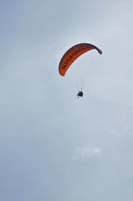
Above Queenstown, paragliders soar through the air. These paragliders are allowed to land on the soft grass of the extensive playground of the primary school – except during playtimes, of course. With the fee the school receives for this, they purchase computers and other educational tools.
Oh, things move quickly in Queenstown nowadays, Brynt sighs. Ten years ago, in February or March, tourists had no reason to visit. Shops, restaurants, and pubs were tightly closed. Nowadays, it's bustling all year round. In winter, there's snow tourism on the Coronet. Even when there's no natural snow, they have 140 snow machines that can lay down a thick layer of twelve centimetres of snow in the morning. Brynt knows it well; he works there during the winter season.
It's bustling all year round in Queenstown these days
Queenstown – Lake Esplanade
We get dropped off in the city centre and stroll through the bustling streets towards the botanical garden. It's one of the most significant local attractions, appealing to both tourists and locals.
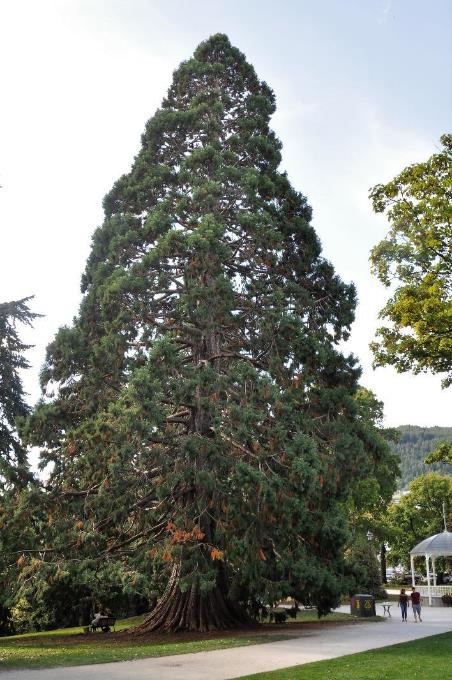
Back in the day, they wasted no time. As early as 1866, the idea of establishing a botanical garden on this peninsula took root in the fledgling Queenstown. This was barely six years after William Rees became the very first European settler here.
Botanic Garden – Wellingtonia (sequoia) |
|
Paraglider |
Among the heritage trees planted by the first mayor of Queenstown, the attention is particularly drawn to the mammoth trees. They are called Wellingtonias here, these sequoias that are actually native to California. They must have been planted around 1875. In the meantime, they have grown into impressive giants, with a circumference of more than twelve meters.
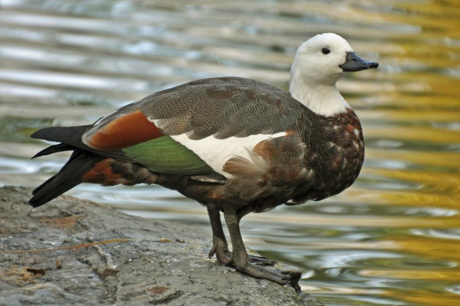
Paradise shelduck (f)
On the edge of the pond, charming paradise shelducks flaunt their colourful plumage. In the famous Rose Garden, withered roses announce the arrival of autumn.
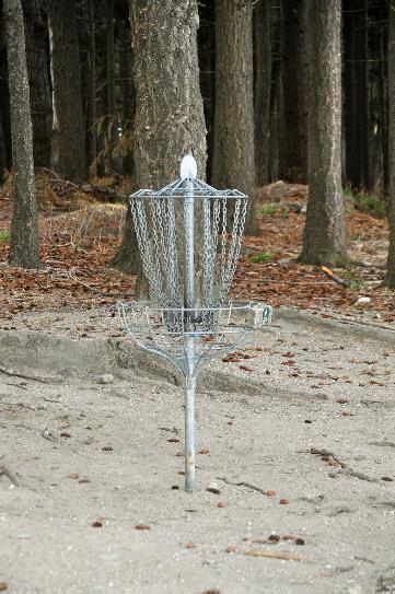
Sports enthusiasts also find their way here. Around the peninsula, a circuit with 18 holes has been designed. Golf, you might think spontaneously. But that is only half the truth. Because this is disc golf, a low-budget version of traditional golf. The holes are 60 to 70 meters apart and consist of poles with metal chains and a basket attached. If you throw a frisbee in the right way against those chains, it neatly falls into the basket. So the goal is to complete the entire circuit with as few throws as possible with your frisbee. Just like in traditional golf, in competitions, different frisbees will be chosen depending on the throw – a driver for long distances, a mid-range for medium distances, and a putter to finish the hole.
Disc golf – Hole |
|
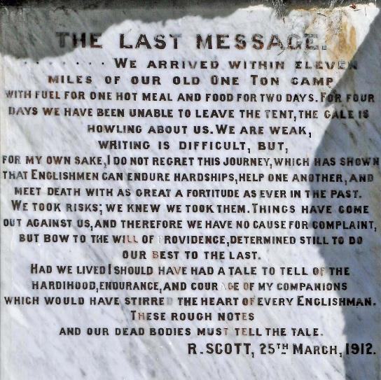
The last message from Robert Scott |
A monument for William Rees is a fitting presence in this environment. More surprising, however, is the presence of a monument for Robert Scott. Or maybe not, as New Zealand was the last port the British explorer visited before heading to Antarctica, never to return.
These rough notes and our dead bodies must tell the tale
His final words, penned in his diary on March 25, 1912, just before his death, are quoted there: “Had we lived, I should have had a tale to tell of the hardihood, endurance, and courage of my companions which would have stirred the heart of every Englishman. These rough notes and our dead bodies must tell the tale.”
Jaak Palmans
© 2024 | Version 2024-02-04 15:00
Continue reading in (8/11)
Carved out by a giant