How the world began
New Zealand | Anno 2019
Sunday, March 10 | Auckland – Rotorua
Sunday, March 10 | Auckland – Rotorua
There may not be much difference between the two largest islands of New Zealand. That's the impression one gets when looking at them fraternally side by side on the map, separated only by Cook Strait. In terms of size, they are evenly matched, with the North Island being four times the size of Belgium and the South Island five times.
Over time, the North Island was shaped by fire, while the South Island was shaped by ice
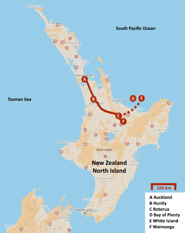
Yet, there is a fundamental difference. To put it figuratively – over time, the North Island was shaped by fire, while the South Island was shaped by ice. In the south, you encounter an alpine environment with glacier valleys and kettle lakes, while in the north, you are confronted with the pockmarked appearance of volcanoes and crater lakes. Nowhere is this contrast better experienced than in Rotorua, the geothermal centre of New Zealand. Today, that's our destination. With over 230 km ahead, this journey is an excellent time to learn more about New Zealand.
As we leave Auckland behind on this sunny Sunday morning, a symmetrical volcanic cone dominates the horizon in the distance to the left. That's Rangitoto, the largest in this volcanic field and also responsible for the most recent eruption, approximately six hundred years ago. The eruption was so intense that it still forms part of the oral tradition of the Māori. In total, a staggering 2.3 km³ of lava was ejected into the air. It may not seem much until you realize that it's enough to cover Belgium with a layer of 7.5 cm of lava.
However, the volcanism of Auckland is not the same as that of Rotorua. While Auckland deals with a magma bubble, in Rotorua, colliding continents are the source of all trouble. New Zealand lies precisely on the line where the Pacific Plate and the Indo-Australian Plate collide. It's the Pacific Plate that loses out and is pushed under New Zealand. Geologists call it subduction. And it doesn't happen smoothly. There is quite a bit of turmoil in the form of earthquakes and volcanism.
It may not be cosy – a magma bubble here, subduction there – but the Kiwis have learned to live with it
It may not be cosy – a magma bubble here, subduction there – but the Kiwis have learned to live with it. Their situation is not unique, though. In countries like Indonesia, Japan, Alaska, Bolivia, and Chile, people know what it's like. All these countries are located on the Ring of Fire, a horseshoe-shaped area spanning the Pacific Ocean where earthquakes and volcanic eruptions are a daily occurrence.
Across New Zealand, GeoNet records 50 to 80 earthquakes per day, or about twenty thousand per year. Usually, you don't feel anything. But we are well-prepared. So, we are given a list of practical guidelines – what to do before, during, and after an earthquake. Always knowing where the emergency exit is in the hotels we stay in, for example. Or seeking cover and definitely not running around during an earthquake.
Overall, the standard of living in New Zealand is very good, we learn, as we travel southward under a cloudless sky on State Highway 1. On average, men live to be 79, women to 83 – at least among the white part of the population.
The average income of a Kiwi is € 22,500. If you are older than 65, you receive a government pension of € 700. This system was introduced as early as 1898.
Complicated tax forms are not welcomed here. Fifteen percent tax for everyone, no deductions. It can be that simple
Complicated tax forms are not welcomed here. Fifteen percent tax for everyone, no deductions. It can be that simple. On top of that, there is a 2 % contribution to a fund that compensates for workplace accidents – but not illnesses.
Living is not cheap here, though, as you would find out if you were to browse through a supermarket. If the minimum wage is $ 15 or about € 9 per hour, and a can of milk costs $ 5, the bill adds up quickly.
It becomes really dramatic when considering the purchase of a house or an apartment. Because in the Auckland area, you might have to shell out € 560,000 for that. In barely five years, housing prices have increased by 80 %. This is almost entirely due to the recent wave of migration encouraged by the centre-right government of John Key. It was mainly affluent foreigners who felt appealed, particularly Chinese from Singapore or wealthy traders from India. They significantly drove up property prices.
Meanwhile, measures have been taken to address this. Foreigners can no longer buy real estate. This is an achievement of Jacinda Ardern and her centre-left government. Jacinda Ardern? We have never heard of her. Little do we know that in less than a week, her face will appear on TV screens worldwide.
Since 1893, women have had the right to vote
Women in politics – few countries score better on that front than New Zealand. Since 1893, they have had the right to vote here. For comparison, in Belgium, women only gained the right to vote in 1948, more than half a century later.
Whether by coincidence or not, many top positions in New Zealand today are held by women. Alongside Prime Minister Jacinda Ardern, there are, among others, Governor-General Patsy Reddy and Chief Justice Sian Elias. Even the head of state is a woman, namely Betty Windsor – better known as Queen Elizabeth II.
Meanwhile, we continue our journey southeast along the Waikato River. It's a radiant day, with hardly a cloud in the sky.
Our attention is drawn to waving toetoe grasses with cream-colored tufts. This endemic plant can grow up to three meters high and is related to South American pampas grass. Māori used it to make baskets, mats, wall coverings, and roofing. But the plant also came in handy for treating burns, bleeding, diarrhoea, and kidney problems.
James Cook called the bushes we see here and there alongside the road tea tree back in the day. That's because his crew made tea from the small, evergreen leaves. The Māori did the same, but for them, it was mainly about the medicinal properties of this mānuka, used as an antibiotic for tattoos or urinary tract infections. An infusion of the leaves could also be used to combat colds and even fever.
If you are unskilled or very old – over thirty, to be precise – as a foreigner, you don't stand a chance of obtaining a permanent residency permit
Children are not obligated to attend school until the age of six. Turning sixteen is a significant moment in a young person's life: you no longer have to go to school, and you are allowed to sit behind the wheel of a car.
Travelling through New Zealand and earning a living in the hospitality industry or on a farm – many Western youths dream of this. And often, that dream comes true, as obtaining a Working Holiday Visa for a period of up to one year is relatively straightforward. That is, if you are between 18 and 30 years old, have $ 4,200, and behave reasonably.
However, permanently moving to New Zealand is a different story. You need to score at least 100 points on a list that assesses your personal characteristics and qualifications. If you are unskilled or very old – over thirty, that is – you don't stand a chance. If you score higher than 140, you receive an Invitation to Apply. This means they would be delighted to have you. However, they are quite selective.
The possibilities for producing sustainable energy in New Zealand are almost unlimited
In the meantime, we made a stop in Huntly. The broad Waikato River flows gracefully alongside the elongated town. Across the river, the buildings of the Huntly Power Station impress, the largest thermal power station in the country. The four turbines together generate 1,000 MW. However, in these times of CO2 emissions, they are a thorn in the side of environmental organizations. Not entirely unjustified, as the possibilities for producing sustainable energy in New Zealand are almost unlimited. Eighty percent of the energy comes from hydroelectric power, and another eight percent is of geothermal origin.
The fauna and flora of these islands are quite unique, and there is a reason for that. Once, all continents on Earth were united in a supercontinent called Pangea. About 175 million years ago, that came to an end. It first split into two parts – the northern Laurasia and the southern Gondwana. Gradually, Gondwana also broke into pieces. Africa was the first to leave the parental home 130 million years ago, followed by India, South America, Australia, and eventually... Zealandia.
Indeed, Zealandia. Not New Zealand. Because nowadays, geologists more or less agree that New Zealand and New Caledonia together form a microcontinent. A trench 25 km wide separates this Zealandia from Australia. With an area of 3.5 million km² – mostly underwater – it covers about three-quarters of the 28 countries in the European Union.
Why are we so sure that New Zealand was once connected to all these other continents? We owe that primarily to the glossopteris – a fern we have never heard of. We don't need to feel guilty about that because the plant has been extinct for 250 million years.
Apparently, the expedition members, despite their life-and-death struggle, found those fossils important enough to carry with them all that time
But in the past, it was one of the dominant plants in Gondwana. It left fossil remains everywhere in South America, Africa, India, Australia, and New Zealand. If you push these continents back together, as was the case during Gondwana, and mark the locations of those fossils, you'll see that they form a cohesive area.
Even the unfortunate Terra Nova expedition comes into play here. The name might not mean much to us, but every Kiwi knows that it was the name of the Antarctica expedition led by the British explorer Robert Scott. In 1910, he set out from New Zealand in search of the geographic South Pole. Upon arrival, he could only conclude that the Norwegian Roald Amundsen had beaten him by 34 days. As if that weren't enough, on his return, Scott failed to reach his last food depot, and he and his team died of hunger and exposure.
But when their frozen bodies were found half a year later, they also discovered sixteen kilograms of fossils. Apparently, the expedition members, despite their life-and-death struggle in temperatures as low as –40 °C (–40 °F), found those fossils important enough to carry with them all that time.
And they were right. Because these were fossil remains of the glossopteris – the missing link in the geological puzzle. Even in Antarctica, this fern had flourished. Which is not evident when you consider that it had to endure six months of complete darkness without photosynthesis. How it managed that is still unclear.
Back to New Zealand. There, a unique developmental history in splendid isolation began about 85 million years ago with the separation from Australia. Dinosaurs had already managed to reach New Zealand at that time; fossil remains are still found there. But for marsupials and mammals, it was too early. They were still evolving only in Eurasia.
During this time, New Zealand was mostly covered by shallow seas, with some swamps and lowlands here and there. Whether the islands completely disappeared underwater about thirty million years ago is still debated among scientists.
Regardless, the archipelago eventually evolved into a bird paradise. There were no mammals – except for two species of bats – and even fewer predators. Birds could go about their business undisturbed, occupying all the niches that elsewhere would be filled by mammals. Even heavy flightless birds like the moa had nothing to fear. In short, a true Garden of Eden.
The Māori are sometimes referred to as the original inhabitants of New Zealand, but they are not truly original
That was also the opinion of the Māori. They are sometimes referred to as the original inhabitants of New Zealand, but they are not truly original. In fact, they originated from the Polynesian islands. In their oral tradition, they call their mythical homeland Hawaiki. We do not know exactly where that is. It certainly has nothing to do with modern Hawaii. Hawaiki could correspond to the Cook Islands, Tahiti, or even the Marquesas Islands – more than 5,500 km away, across open sea.
In their homeland, the Māori faced overcrowding and food shortages. Occasionally, this led to wars. So, they set out in search of a better place, against the prevailing ocean currents. This was a clever move because, in case of need or danger, they could easily return to their safe haven.
We do not know the exact details of the migration. The oral tradition mentions a number of waka hourua, large boats capable of long journeys across the ocean. The names of some of these boats are still engraved in the collective memory of the Māori. Some Māori families even believe they can trace their origins to the occupants of one of these boats.
It is not ruled out that the first explorers set foot on New Zealand around 700. They navigated using the stars, ocean currents, prevailing winds, as well as the movements of birds, whales, and even patterns of waves at sea.
The migration might have been well underway around the year 1000, but scientific certainty is only obtained around 1280. From then on, the permanent presence of the Māori in New Zealand cannot be denied. We owe this knowledge primarily to... rats. The oldest seed cones with their gnawing marks date back to 1280.
Polynesian rats travelled as stowaways with the Māori. Dogs were also on board, but strangely, there were no chickens or pigs – even though they are useful animals when building a new life somewhere. Why these animals were missing from the checklist when the Māori were packing their bags remains a mystery.
People in the Garden of Eden, that leads to trouble. Just read the book of Genesis
This is how the Māori ended up in the earthly paradise that New Zealand was then. However, people in the Garden of Eden, that leads to trouble. Just read the book of Genesis.
Firstly, there were the rats. In this pristine nature, they had no resistance to fear. Among their first victims were the New Zealand little bush moa, which had the misfortune of nesting almost unprotected on the ground. Soon, they were completely wiped out.
But the Māori were not idle either. They quickly started hunting the moa, a large flightless bird. There were nine different species, and you could find them everywhere – from sea level to the mountains. With a length of 3.6 m, the moa even overshadowed the contemporary ostrich, which doesn't grow larger than 2.8 m.
A bird weighing 230 kg, peacefully grazing in the meadow and unable to fly away when chased – this was a grateful prey for the Māori and a welcome addition to their diet. Less than a century and a half later, the moa was extinct.
Someone who wasn’t amused by this was the Haast's eagle, the largest eagle of all time. Moas were its favourite dish. Once the moas were exterminated, the Haast's eagles soon suffered the same fate.
And it could get worse because a few centuries later, the Europeans arrived. Besides rats, there were now – intentionally or not – stoats, weasels, and wild cats on the scene. For these predators, it was a feast, with all those birds that had never learned to fear other animals. Dogs and rabbits also made their appearance.
Deer were intentionally introduced to provide hunters with their fun. This had detrimental effects on the native vegetation and on the birds dependent on it. In the 1970s, many of these deer were captured and placed on deer farms.
But the biggest blunder was made around 1850 by Australians. To boost the fur industry, they released in Riverton the common brushtail possum, a climbing marsupial with a thick, woolly coat, a distant relative of the opossum.
To boost the fur industry, they released the common brushtail possum, a distant relative of the opossum. What a miscalculation that turned out to be
What a miscalculation that turned out to be. In Australia, brushtail possums were besieged by a host of predators – dogs, cats, foxes, quolls, morelia snakes, goannas, falcons... But in the paradise of New Zealand, nothing hindered them. With two litters per year, the brushtail possum could reproduce unchecked. In 1980, their population was estimated to be between 60 to 70 million.
The consequences were incalculable. Brushtail possums were found to transmit bovine tuberculosis – not particularly good news in a country with nine million cows. Furthermore, they caused significant damage to native trees, especially the rātā. As if that wasn't enough, these so-called leaf-eaters did have a taste for bird eggs and chicks.
Putting an end to this is one of the Herculean tasks of the Department of Conservation (DOC). Over the past thirty years, they have managed to reduce the number of possums to just thirty million.
Over the past thirty years, they have managed to reduce the number of possums to just thirty million
Driving through gently hilly terrain, we continue southeast. It's sunny, with almost no clouds. We won't see any brushtail possums since, like opossums, they are only active at night. Still, metal cylinders around the wooden power poles along the road constantly remind us that they are indeed present. These rings are meant to prevent them from climbing the poles and damaging the wires.
Gradually, we approach the Bay of Plenty. This name was coined by James Cook. He was astonished by the enormous food supplies of the local Māori. Today, it is also the name of one of the sixteen regions of New Zealand.
This region still constitutes the heartland of the Māori, making up about 35 % of the local population. This is not surprising, considering that if you approach New Zealand from the northeast by sea, you are likely to end up in the Bay of Plenty. And you might stay there, given the fertility of this area.
The only significant port on this coast is Tauranga, a noble unknown to us. Yet, this is the place from which kiwis are shipped to Zeebrugge in Belgium. Moreover, Zeebrugge is considered the kiwi port of Europe. About 1.2 billion kiwis arrive there every year, accounting for twenty ships or a third of New Zealand's production.
It takes two months for the fruits to reach Western Europe, but that doesn't bother them. The transport occurs in refrigerated ships at a temperature just above 0 °C (32 °F). In such conditions, a kiwi is supposed to maintain its quality for up to a year.
Gradually, we climb away from the alluvial plain. We now head eastward over the southern foothills of the Kaimai Range. These remnants result from volcanic eruptions that came to an end about 140,000 years ago.
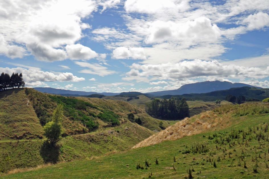
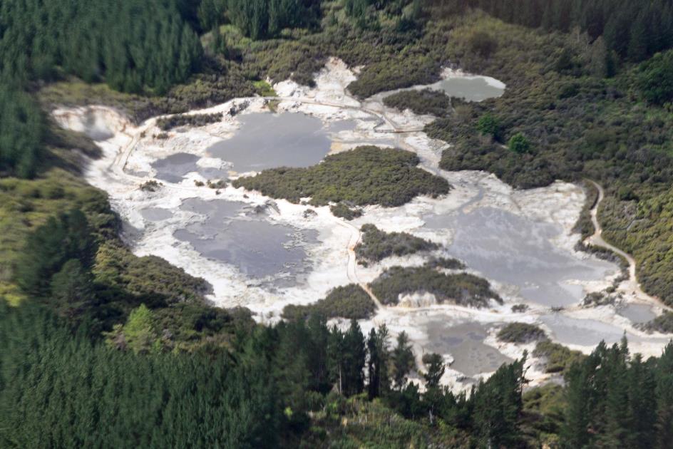
Rotorua Crater Lake with Mokoia Island
They haven't named this road the Thermal Explorer Highway for nothing. It is one of the few roads across this challenging mountain range, unlocking Rotorua and its surroundings. The heart of geothermal activity on the North Island is this, where geysers, hot springs, and mud pools are part of everyday life. Today, it is one of New Zealand's hottest tourist destinations, and it has been so for over a century. Thomas Cook, the pioneer of mass tourism – not to be confused with James Cook, the explorer – already recognized its potential at the end of the 19th century.
Thomas Cook, the pioneer of mass tourism, already recognized its potential at the end of the 19th century
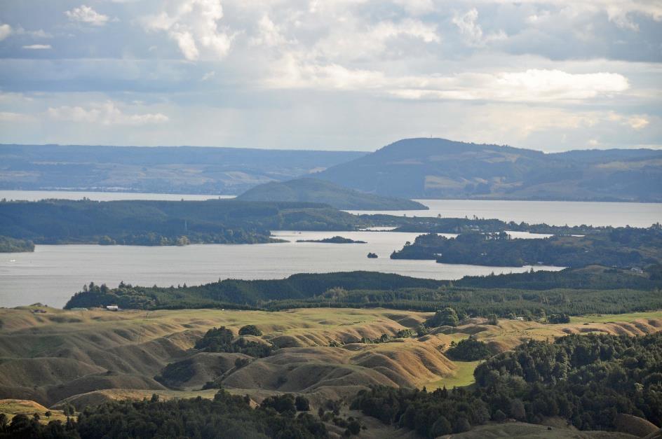
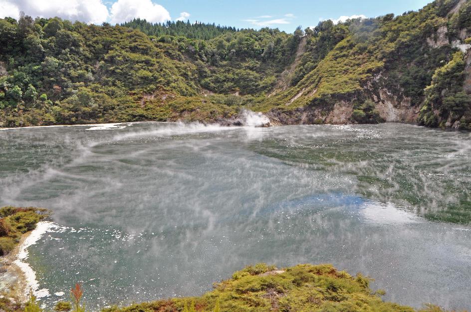
Then, in the distance, the enormous crater lake of Rotorua emerges, about three hundred meters above sea level. There used to be a volcano here, but its last eruption was 240,000 years ago. After that eruption, the magma chamber collapsed, creating this gigantic caldera. In the middle, a lava dome remained. That is now Mokoia Island, a cone-shaped rock rising 180 m above the water surface.
With an area of 80 km², it seems like an enormous body of water, but on average, it is no deeper than ten meters. This plays a bit against it, as the shallow water easily changes colour when sediment washes in from the hills. Water sports enthusiasts are not so keen on that.
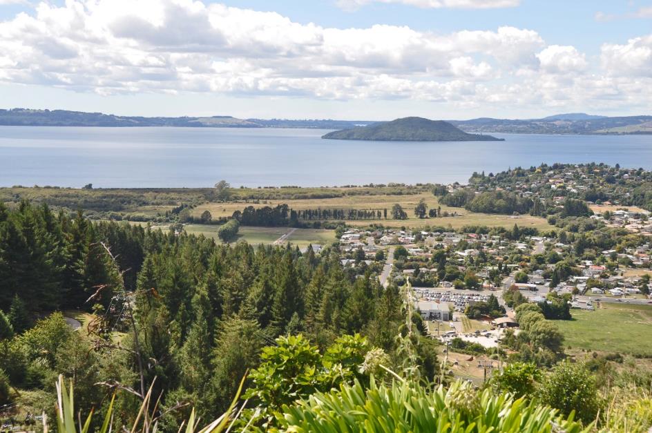
Lake Rotorua – Cable car
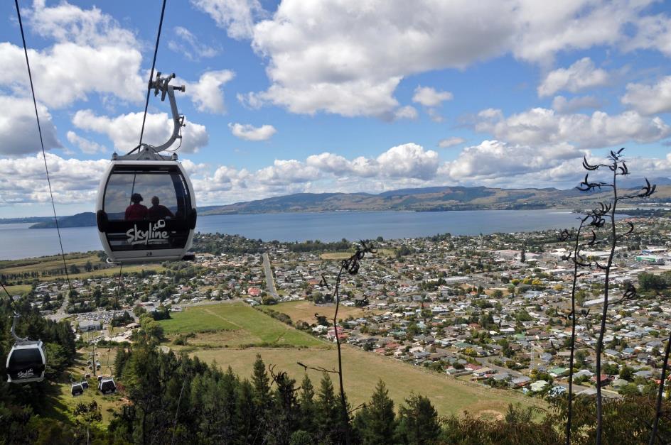
Just before twelve, the gondolas of Skyline Rotorua take us from the parking lot at the base of Ngongotaha to Stratosfare. Not to the upper layer of the atmosphere, to be clear, but to a restaurant with that name higher up on the mountainside.
Quite a few gondolas are reserved for mountain bikers. They have their metal horses hoisted up by the cable car, only to race downhill at breakneck speed.
And that's not the only way to get your adrenaline pumping here. Luge is practiced by young and old alike. It's a form of sledding, with a sled that you can control to a limited extent via a steering bar. On four wheels, you then thunder down a narrow track. Under the motto Once is never enough, you can take the chairlift back up while your sled dangles beneath your seat.
We take it a bit easier. Choosing between the dishes on the buffet at Stratosfare is exciting enough for us.
Entering Rotorua, it seems like an ordinary town, one of thousands, bathed in sunlight. On the Sunday Craft Market, hobbyists offer their handmade goods for sale. People enjoy the beautiful weather, strolling between the tents.
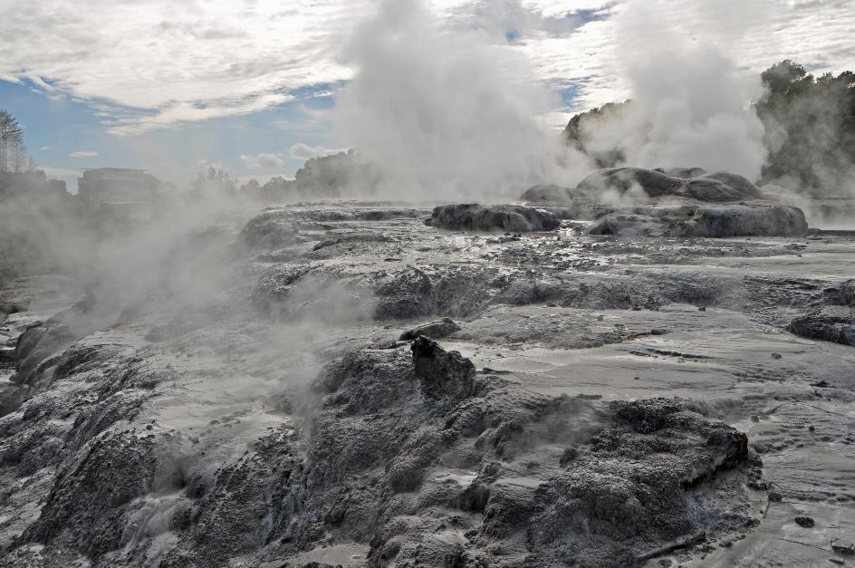
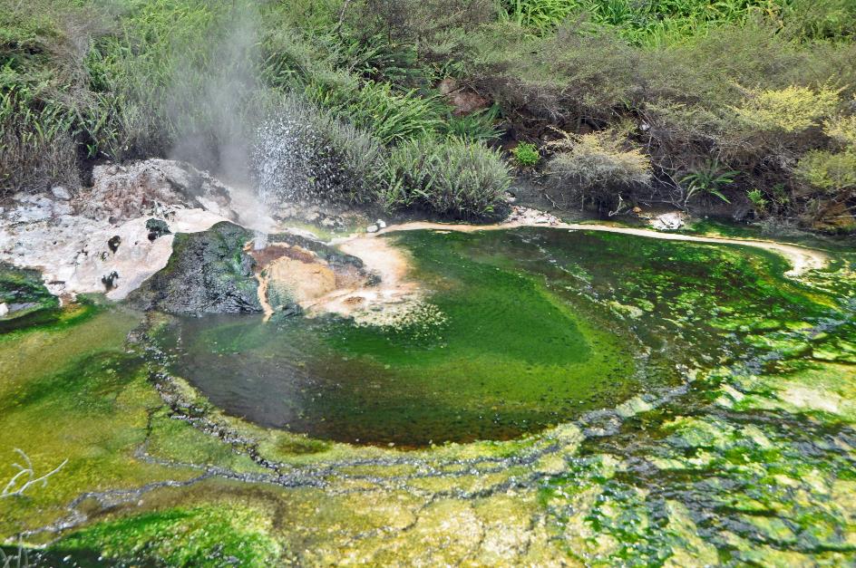
But looks can be deceiving. Mysterious steam clouds hover low above a pond next to a busy intersection. Elsewhere, a white plume of mist rises high above the houses. Geothermal activity here is not something found in nature, a bit outside the city. Geothermal activity is omnipresent; it permeates the city in all its pores. Basements under the houses are simply unthinkable due to the heat.
As a welcome, an unmistakable sulphur smell wafts toward us on the hotel's terrace. Even in the hotel corridors, we can't escape a whiff. Sulphur City lives up to its endearing nickname.
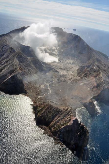
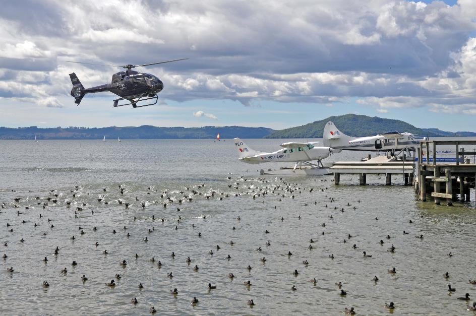
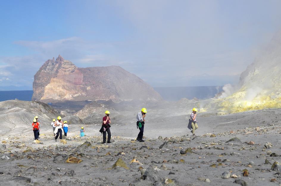
Yet, this is precisely why we came here – volcanism in all its forms. And we're in luck because the weather conditions are perfect for a flight to White Island. It's a top attraction, New Zealand's most active volcano, about 48 km off the coast.
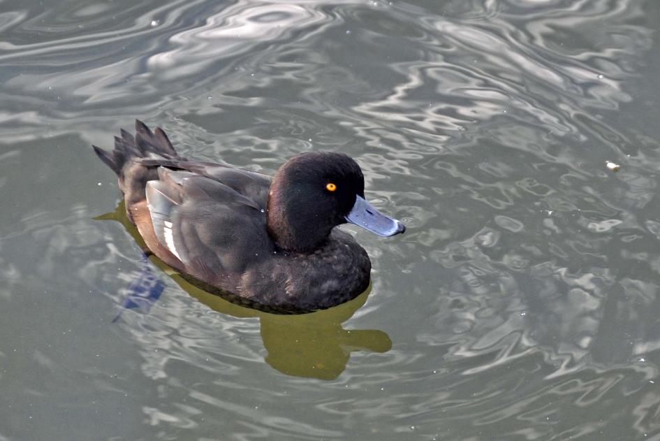
New Zealand scaup
Lake Rotorua, New Zealand scaups
Without delay, we descend to the office of Volcanic Air on the lake's shore. Two seaplanes float on the water. However, it's the many hundreds of brown-black ducks with yellow eyes and blue bills that capture attention. These are endemic, these scaups, found only in New Zealand. And exclusively on one of the many freshwater lakes. Unlike their counterparts in Europe and Asia, they don't migrate. They eat what's available – water vegetation, small fish, molluscs, insects, it doesn't matter. But when coots are nearby, they might sometimes snatch their food.
Whether we have water with us, the pilot asks. Not for thirst, but to counteract the irritating sensation of sulphur in the throat
One by one, three helicopters land on their platform with a lot of noise. The water foams wildly under the thrust of their rotors, but the New Zealand scaups seem unfazed. Apparently, they have grown accustomed to this type of commotion.
Lake Rotorua
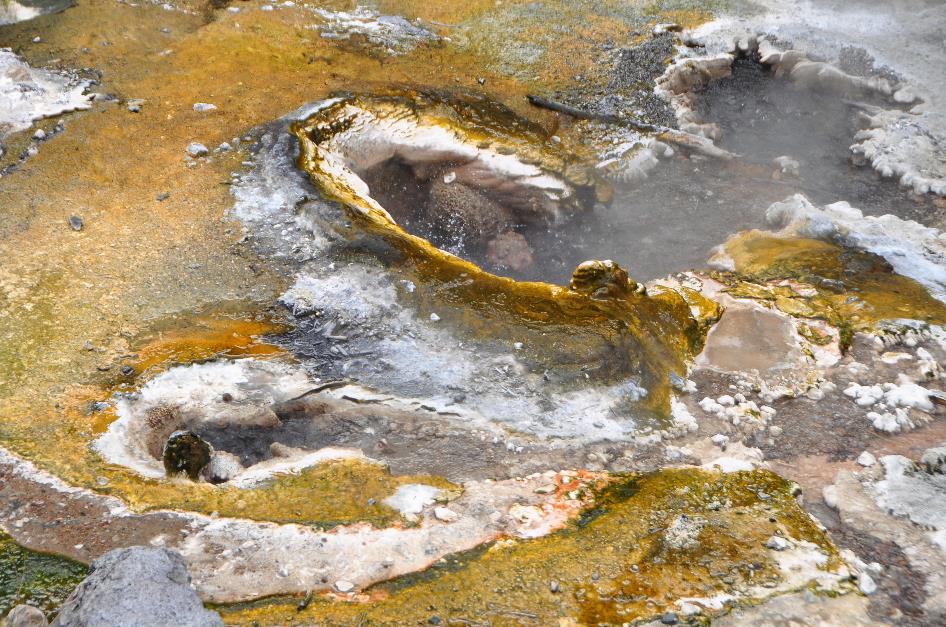
Hot springs
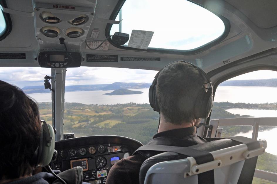
Six of us climb aboard a Eurocopter AS350 Squirrel. Pilot Matt welcomes us. He asks if we understood all the safety instructions while securing our seatbelts and checking that our life vests are properly over our shoulders. And whether we have water with us, he asks. No, not for thirst, but to counteract the irritating sensation of sulphur in the throat.
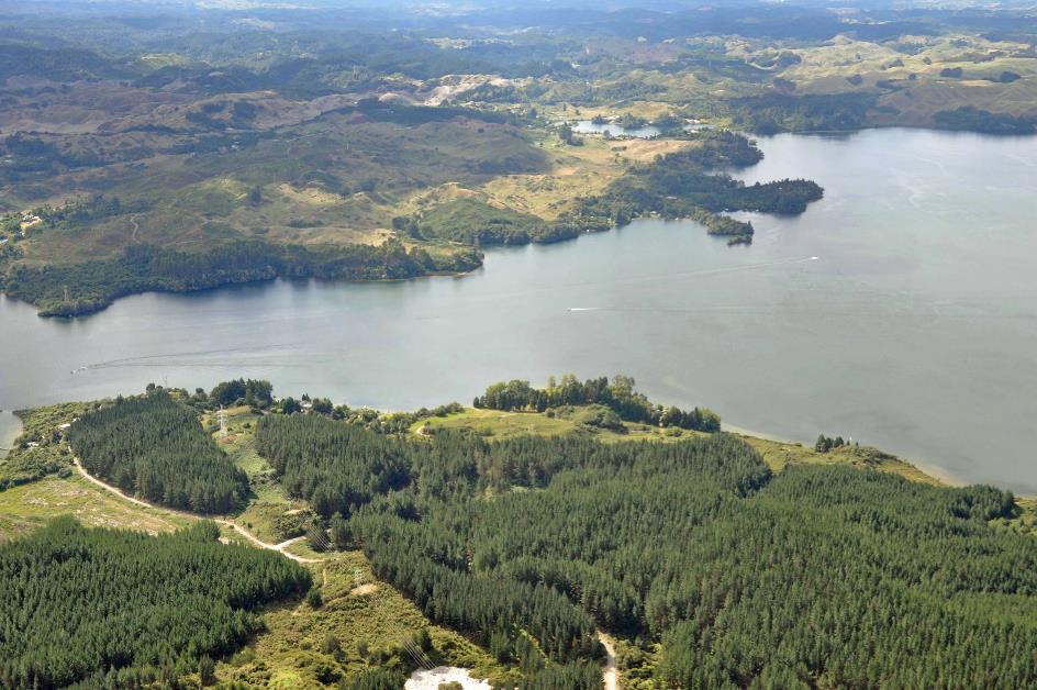
At a quarter past three, the helicopter lifts off its platform. First, Lake Rotorua with Mokoia Island slides beneath us. Then, some kiwi plantations come into view. A strange landscape of hills without valleys unfolds. It looks like a giant green bubble wrap. Then, the coast appears, and the Bay of Plenty stretches out before us.
Kiwi plantations
Lake Rotorua
Soon, a giant dark green cuberdon in the water catches our attention. That's Moutohorā, Matt explains. It used to be a volcano, but you wouldn't notice much of that now, except for a few hot springs. New Zealand declared the island a protected area as early as 1965. They first got rid of the goats, rats, and rabbits that plagued the island. This allowed the fauna to recover, also thanks to new plantings. People are no longer allowed to set foot on it. Various bird species like to nest there – for them, it's nothing less than a paradise.
That’s what the Department of Conservation often does – creating safe havens on smaller islands for fauna and flora
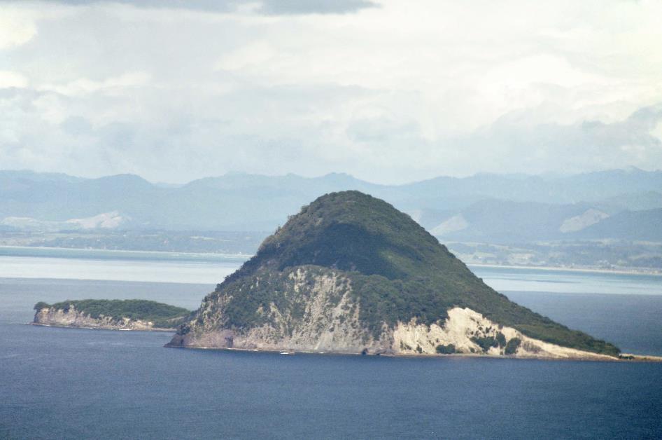
A giant dark green cuberdon called Moutohorā
That is what the Department of Conservation often does – transform smaller islands into safe havens for their own fauna and flora, far from the harmful influence of invasive plants or animals. This is also the case on Moutoki, the tiny rocky point we see in the foreground. There, the tuatara thrives. So well, in fact, that in the 1990s, about thirty of them were transferred to Moutohorā to colonize that island as well.
Tuatara? Yet another creature we've never heard of. But for now, we don't know more than that it's a three-eyed iguana. A three-eyed iguana? Did Matt hit the bottle after all, briefly crosses our minds.
White Island
But it's the white plume on the horizon that captivates all our attention. Travelling at a speed of 122 knots – 226 km/h – it's about a quarter of an hour flying at an altitude of approximately 500 m above the seawater.
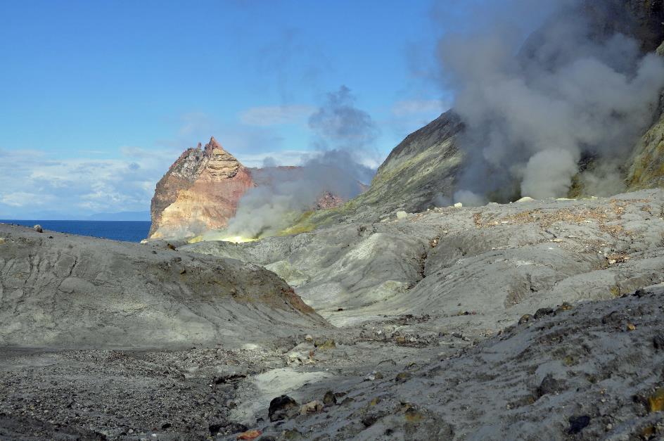
As we approach, White Island takes on a clearer shape. A grey rock wall with a diameter of about two kilometres rises steeply from the sea. It's a caldera, of which the eastern wall has largely collapsed. White mists continuously rise from the core. Green patches on the western flank make it clear that even in this harsh environment, vegetation has seized its opportunities.
The highest point of the rock wall is 321 m above sea level. But that's deceptive. If we could take a look underwater, we would see a volcanic cone rising 1,600 m above the surrounding seabed. Moreover, we would see a series of volcanic cones neatly lined up along the fault line between the Pacific and Indo-Australian plates, spaced 40 to 80 km apart. In total, scientists estimate there must be around ninety of them.
In a wide arc, Matt flies around the white plume and then descends through the eastern opening into the inferno
White Island
In a wide arc, Matt flies around the white plume and then descends through the eastern opening into the inferno. At ten minutes to four, we land on a wooden platform, followed shortly by the other two helicopters.
White Island |
|
The edge of the crater lake |
On the most active volcano in New Zealand, you don't stroll around without a safety helmet and a gas mask, as it turns out. Despite this volcano being over 150,000 years old, the most recent eruptions occurred in 2012, 2013, and 20171). Consequently, various monitoring instruments are strategically placed to closely watch over this restless giant.
White Island
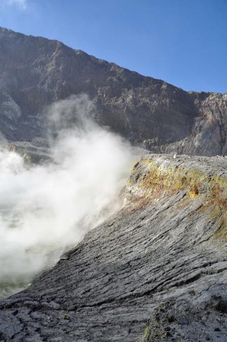
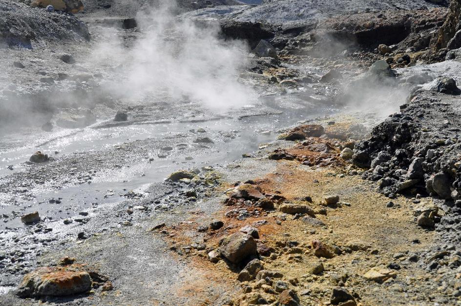
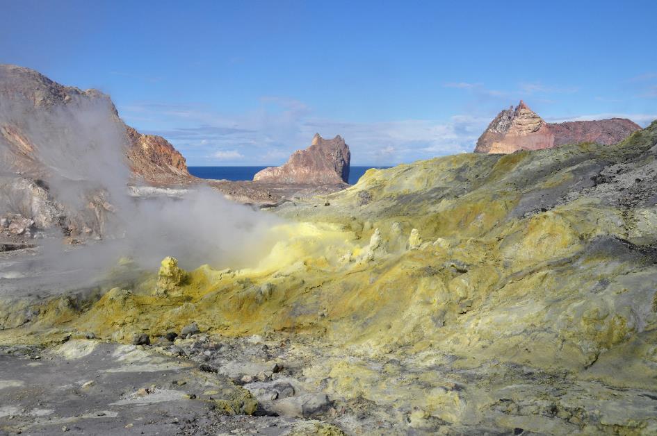
Our exploration of this apocalyptic environment can begin. There is no vegetation to be seen anywhere; it looks like a lunar landscape. White plumes of smoke rise from the crater walls here and there. Those are fumaroles, says Matt. Water seeps down through the porous ground and encounters increasing pressure and temperature. Gradually, the water becomes overheated and, as water vapour, finds its way back up. We notice the yellow sulphur deposits around the fumaroles, indicating that sulphur dioxide dissolves in the water along the way.
A few coughing fits later, we stand on the edge of the crater lake, with our gas masks on
A little higher up, a gigantic plume of mist rises from the crater. Clear water trickles down its flank like a thin stream. Above the water, there are clouds of water vapour, and the edges are brownish-yellow from sulphur deposits. Carefully, we gauge the temperature of the water – our estimate is 35 to 40 °C (95 to 104 °F).
Fumaroles
Let's take a look into that crater, suggests Matt. And he apparently means it. A few coughing fits later, we stand on the edge of the crater lake, with our gas masks on. Swirling water vapour clouds permeated with sulphur dioxide fill the basin. Like ghostly shadows, we stand in the billowing mists, waiting for the crater to reveal its inner self. And eventually, it does, as there is some wind. About ten meters lower, the brown, restless water sparkles in the sun.
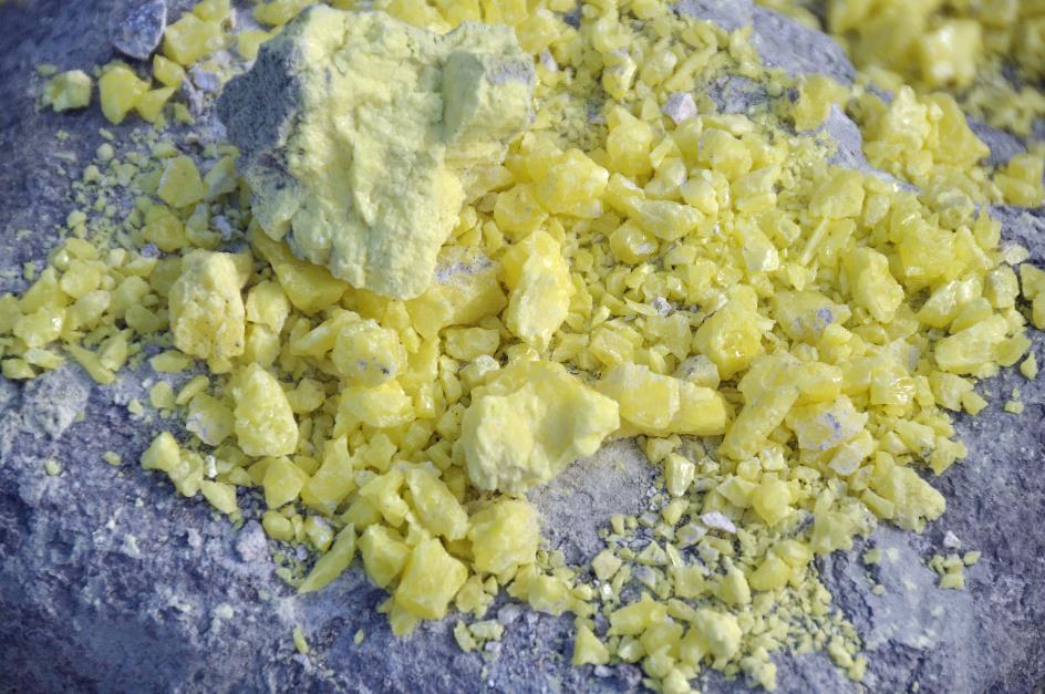
Sulphur crystals
Remarkable are the intense yellow colours around some fumaroles. Beautiful sulphur crystals lie there for the taking. Mining sulphur was the only reason to buy this island for a long time, as it has always been in private hands. The first sulphur mine started here in 1885. Barely a year later, they called it quits after the Tarawera erupted – one of the largest eruptions to ever hit New Zealand. They must have thought it could happen here too before they made a run for it.
Digging up sulphur in this hostile environment without any form of protection seems hardly imaginable to us
Sulphur deposits
It didn't take long for the work to resume. Digging up sulphur in this hostile environment without any form of protection seems hardly imaginable to us. Yet they did.
In September 1914, disaster struck. A mudflow of volcanic material – geologists call it a lahar – bulldozed the camp into the sea. The bodies of the ten workers were never found.
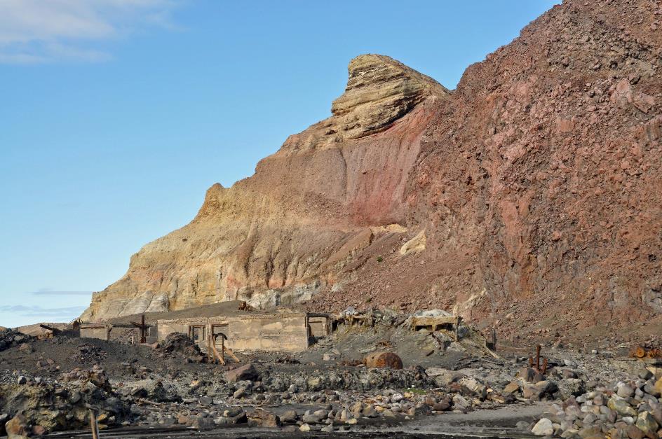
Former mine buildings
Believe it or not, barely ten years later, the sulphur mine was operational once again. However, the world had decreasing demand for the inferior sulphur from White Island, as it no longer met the requirements for fertilizer production. In the 1930s, the mining activities were halted.
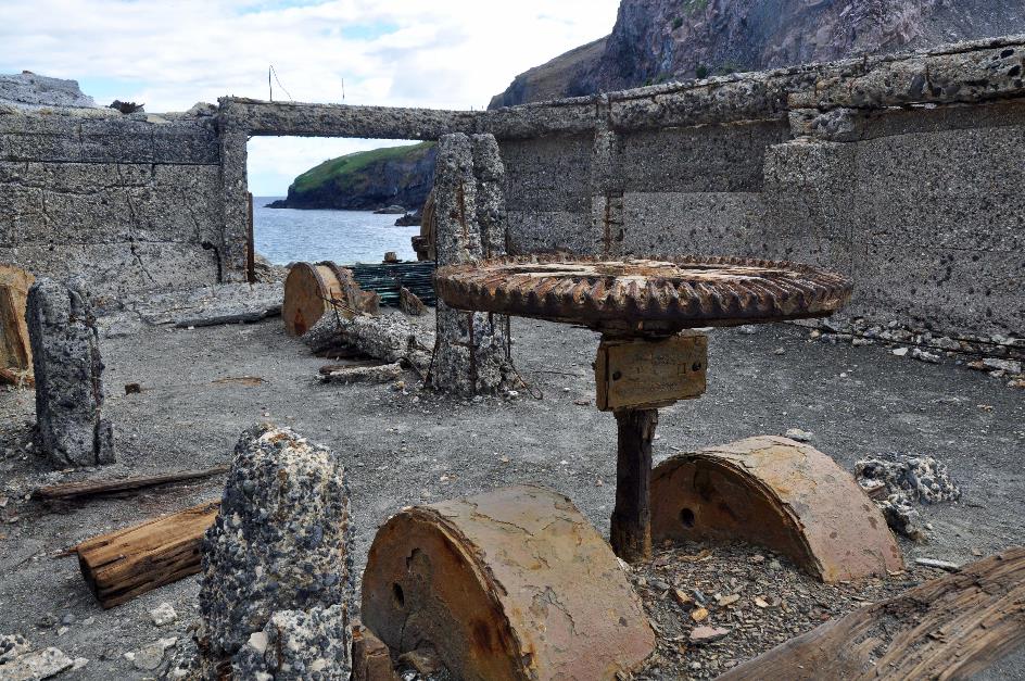
Corrosion in a hostile environment
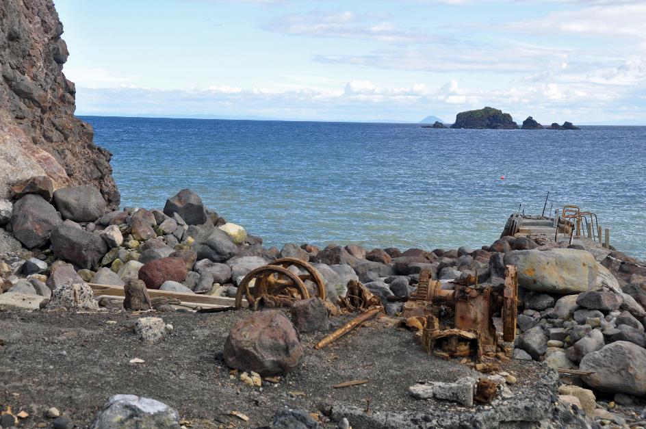
Nowadays, only the ruins of the factory remind us of that period. What's left of the metal machines can't withstand this ruthless atmosphere. Even the reinforced concrete seems affected by an internal cancer. Corrosion causes the rusty steel to swell, and the concrete to crumble.
On the beach, one of the pilots sweeps away a few centimetres of sand. The little hole feels quite warm. But then he digs a bit deeper – not much, perhaps twelve to fifteen centimetres. Yet, the pit already feels quite hot, probably around 50 to 60 °C (122 to 140 °F). That's how it goes when there's a magma bubble two kilometres beneath your feet.
That's how it goes when there's a magma bubble two kilometres beneath your feet
At a quarter past five, our Squirrel ascends above the desolate terrain. On the green southern flank of the caldera, Matt points out some busy bird colonies. Australasian gannets sit closely together, but still far enough apart not to get into trouble with their neighbours. The nests are simple – shallow bowls in the volcanic ash, filled with seaweed, plants, and bits of wood. Mr. Bird provides the building blocks, and Mrs. Bird assembles the nest.
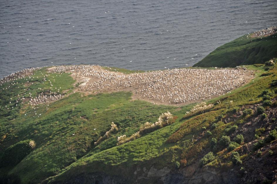
Colony of Australasian gannets
It takes a hundred days before a chick leaves the parental nest. It will then cross the Tasman Sea on its own and spend three to five years on the Australian coast. But eventually, it will return to this place to find a partner and continue its lineage.
Half an hour later, we set foot in Rotorua. For dinner, we head to Tutanekai Street. They've renamed part of the street to Eat Street, apparently fearing that tourists might otherwise struggle to find the restaurants. It turns out to be a noisy affair, but a delightful sauvignon blanc from Tohu – incidentally, the first New Zealand wine label entirely owned by Māori – makes up for it.
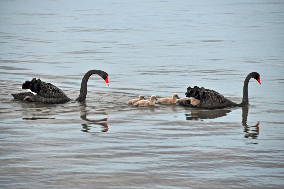
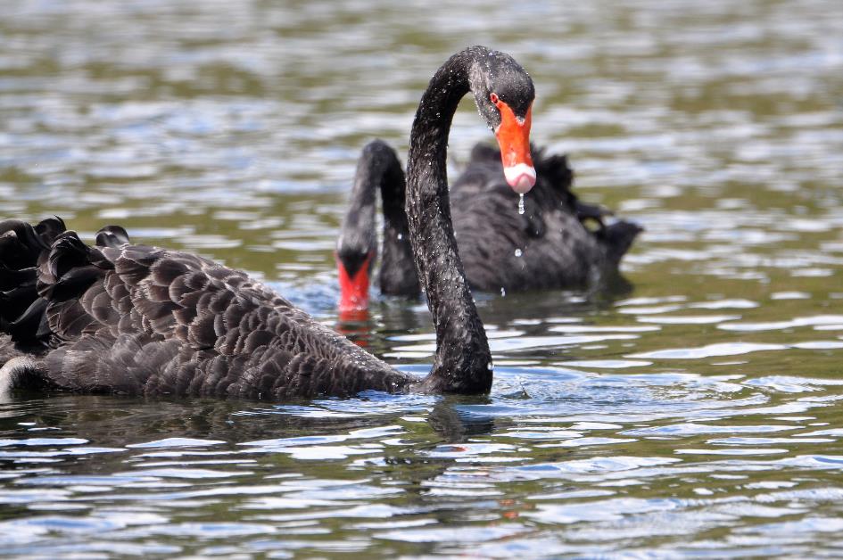
Black swans with chicks
In the twilight, calm has returned to the quay. The New Zealand scaups still bob on the water. However, it's a family of black swans that captures the attention of the strollers. Gracefully, they float on the water, father in the lead, mother behind – or reversed, we don't want to be sexist. And between them, five fluffy bundles neatly in a row. Apparently, their day is done. They come ashore on the muddy bank. Father and mother start collecting dry twigs while the little chicks watch in boredom. That will be their nest for the night.
Lake Rotorua – Pier
Monday, March 11 | Rotorua
Even on the golf course, they can't escape from it – a steam puff here, a mud pot there. With the slogan A unique geothermal golfing experience, Rotorua Golf Club grabs attention. Golfing amid hot springs, it is indeed something different.
The golf course is right across from Whakarewarewa, a geothermal valley. As early as 1325, Te Puia, a Māori fortress known to be impregnable, stood here. Nowadays, Te Puia is the name of the organization that manages all of this.
Rūaumoko has earthquakes and volcanoes in his job description. This Sky Father is the closest to the hearts of the Māori
Te Puia – Sky Father Tangaroa |
|
Sky Father Rūaumoko |
|
Sky Father Rehua |
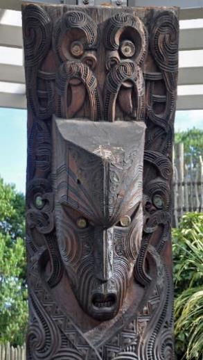
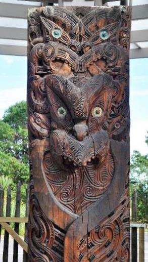
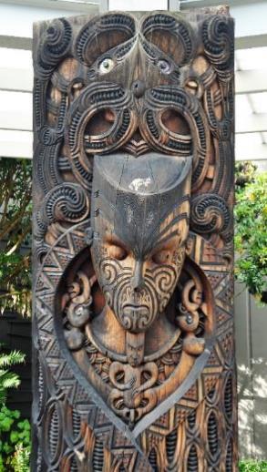
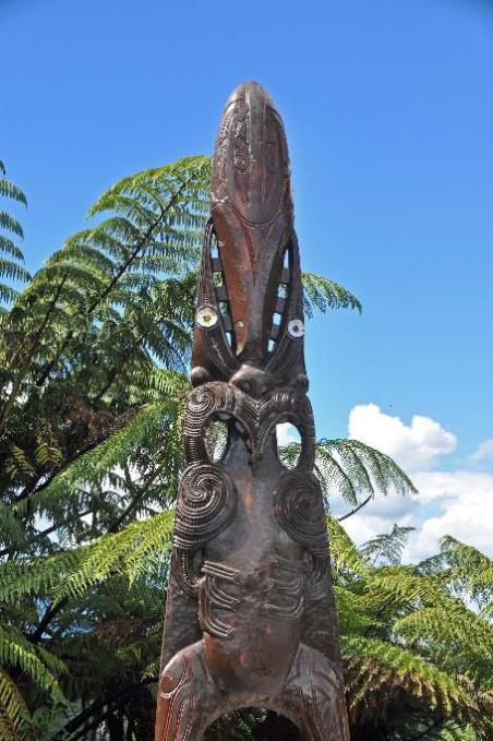
Just before nine, we find ourselves in the middle of a circle with twelve tapering poles. At the top of each pole is a carved head. The celestial origin of our people, that is what this place symbolizes, explains Shania to us. Each of these poles represents one of the twelve Sky Fathers. Everything in this world originated from them – mountains, rivers, lakes, but also people, animals, and plants. Elaborately carved wooden panels portray each Sky Father larger than life at the base.
One of these Sky Fathers is Rūaumoko. He is closest to the hearts of the Māori because he has earthquakes and volcanoes in his job description. Since he lives underground, the ground shakes violently every time he becomes restless. Such a Sky Father, you'd prefer to keep as a friend, especially when you live amidst geysers and mud pots.
What jade is to the Chinese, pounamu is to the Māori
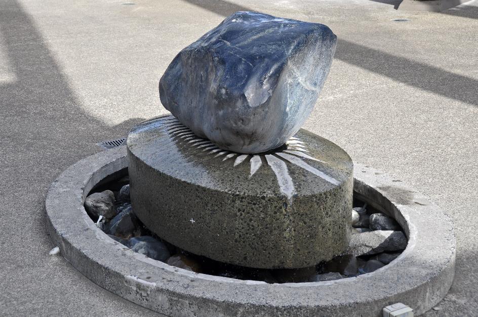
Pounamu
A large stone forms the heart of the monument, symbolizing the earth and its life force present in all objects. It is a gift from the Māori of the West Coast of the South Island. Because only there will you find this green stone, the famous pounamu. What jade is to the Chinese, pounamu is to the Māori.
The path leads us to the geothermal valley. We gaze over the white mists of the geyser field amidst the lush greenery of trees and ferns unfamiliar to us. We find it impressive. Shania disagrees, as the main geyser isn't erupting.
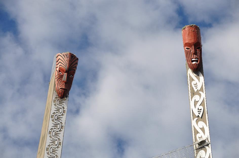
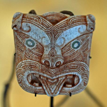
Masks of the Sky Fathers
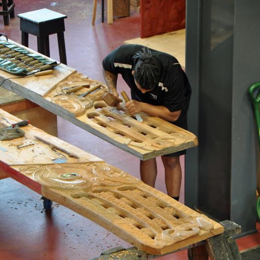
So, we first set our steps towards the Māori Arts & Crafts Institute. This institute dates back to 1926 when the realization dawned that traditional skills of the Māori could be at risk. Since then, it has become a leading centre for arts and crafts. The norm here is no longer just preservation; they aim for full development in creativity.
Ten wooden figures gaze down at us from their pillars as we approach the building. The Māori owe their knowledge to these ancestors. On the left are the men who acquired this knowledge, on the right are the women who selected them for it – although the latter pair is strictly speaking sexless.
Men sometimes tattoo their entire faces. In contrast, women only tattoo their lips and chin
We owe the first couple the art of tattooing. Shania explains that this is an invention of the Māori. Men sometimes tattoo their entire faces to express their identity. In contrast, women only tattoo their lips and chin.
For expert navigation, we turn to the second couple. Here we see the man who once pulled a stingray from the water and placed it as an island in the ocean. Today we call that island the North Island – the resemblance to the fish is striking. In the South Island, we recognize the canoe with which this ancestor travelled, while the much smaller Stewart Island must have served as an anchor.
The third pair specializes in astrophysics. This man had the courage to go to the twelfth heaven and bring back the three baskets of wisdom. Thus, he gave humanity light, darkness, and art.
If you want to learn how to build a sturdy waka or canoe, you can turn to the fourth couple. And finally, the fifth was the guardian of all knowledge regarding wood carving.
Māori Arts & Crafts Institute |
|
|
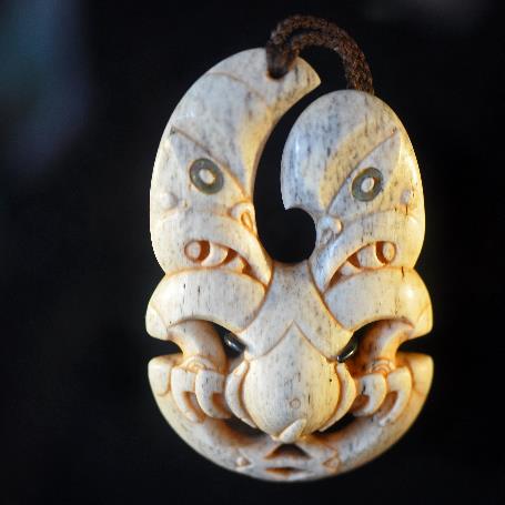
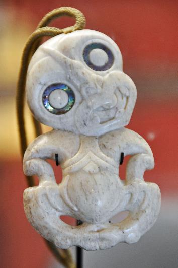
Experienced masters passing on their skills to young artists, that's what the Māori Arts & Crafts Institute is all about. No skill is cherished more intensely here than working with pounamu, the green stone. The intriguing recurring motif of Hei Tiki, an amulet in the form of a human figure, is noteworthy. Invariably, the head is tilted at a 45° angle and disproportionately large compared to the compact body. Whether this is a fertility symbol is not known, although the resemblance to an embryo is not far-fetched.
Intriguing is the recurring motif of Hei Tiki, an amulet in the form of a human figure
Hei Tiki |
|
Woodcarving |
Artefacts are also carved from whalebone. It's not that the Māori hunt whales – New Zealand adheres to international agreements. Only with bleached bones found in nature do they work here.
Further down, a young artist drives his chisel through an enormous wooden panel with powerful hammer blows. Presumably, it will become an image of one of the Sky Fathers.
The Māori primarily wove with New Zealand flax. What cotton was to the Indians, flax was to the Māori. They call this endemic plant harakeke – not to be confused with horokaka, the succulent found on rocky coasts. The long, stiff leaves of flax are implanted in a rosette around the root, similar to the Mexican yucca.
What cotton was to the Indians, flax was to the Māori
Making garments from such stiff leaves that fall pleasantly and softly on the skin is not a given. It involves quite a bit of work. With the sharp edge of a mussel shell, they scrape off the hard upper layer of the leaves, exposing the soft, silky fibres. These fibres are then washed, pounded, and wrung out until they are soft enough.
When you cook the flax fibres, they roll up into tubes. The piupiu is made from them, the famous grass skirt that we love to see around the hips of Māori dancers.
But the fibres can also be strong enough to make utensils – ropes, mats, baskets, sandals, bird snares, eel traps, fishing nets, ... Even giant drag nets were manufactured from them. In 1886, on the occasion of a large tribal gathering in Maketū, a drag net of... 1.6 km long was used.
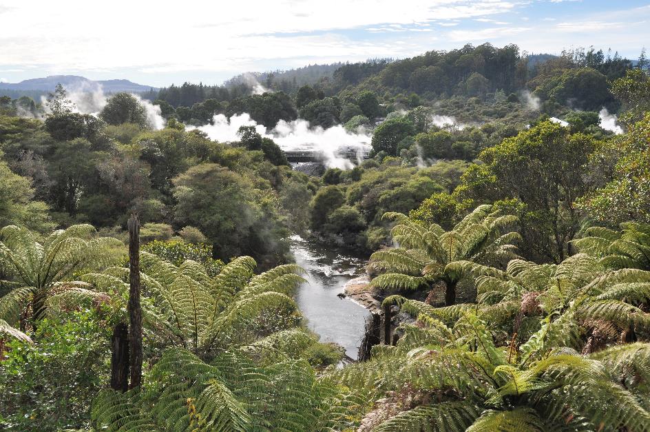
Te Puia – Geothermal valley
Suddenly, news comes in that Te Tohu has started erupting. In itself, nothing special, as Te Tohu is just a small geyser. But it is known as an indicator geyser. If Te Tohu erupts, Pōhutu will not be far behind. And that's a big one. With its fountain of thirty meters, it is even the largest geyser in the southern hemisphere.
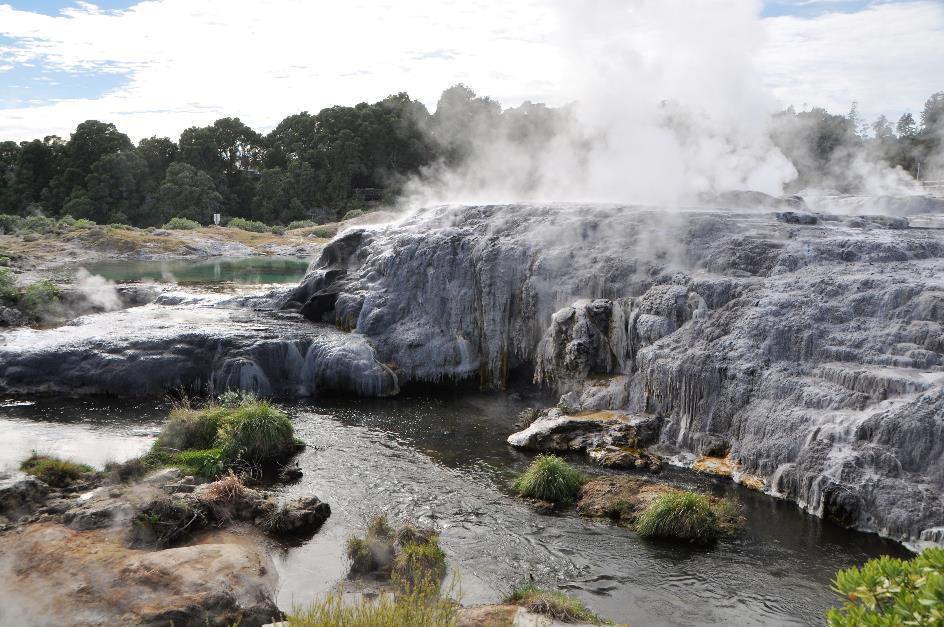
Pōhutu
Hastily, we return to the geyser valley. An apocalyptic scene awaits us there. Glowing hot water saturated with minerals bubbles permanently from the underground. As it seeks its way to the cobalt blue pool of Blueys Pool, it drapes curtains of grey and yellow stalactites on the rugged rocks. White steam veils flutter gently in the wind, playing an incessant game of concealment and revelation. And above all, the inevitable scent of sulphur, to which we have become accustomed by now.
Pōhutu
It doesn't take long before Pōhutu stirs and produces a beautiful fountain, even though it falls a bit short in height. It can't be a celebration every day.
After all, a geyser is a delicate phenomenon. Not only does it require a substantial magma bubble, but you also need a constant supply of water. And, equally important, there must be a reservoir in the underground connected to the outside air by nothing more than a narrow channel.
|
|
|
With its fountain reaching thirty meters, Pōhutu is the largest geyser in the southern hemisphere
Because the water seeping via that channel into that reservoir will become increasingly hot. So hot that it becomes overheated. The pressure steadily increases, but there is no way out. At the top, cold water acts like a valve on a pressure cooker, blocking the narrow channel. But that won't last. Eventually, the pressure becomes so high that the valve gives way, and the geyser can release some pressure and start spraying.
By the way, it can easily take a hundred years for water that has seeped into the ground to reappear through the geyser's nozzle. Not much needs to happen underground to disrupt this delicate system. The fact that the local population likes to tap into hot water doesn't really help. Since 1980, the government has been trying to put a stop to it. For Pōhutu, this meant salvation, but all in all, there are currently only about sixty active geysers in New Zealand. In the 19th century, there were more than two hundred.
Wanting to be a hot spring but not getting enough water, that is the sad fate of the mud pot. Shania shows us the largest one in Te Puia. Glowing hot mud is bubbling in a large pool. Rising gases free themselves with dull thuds from the grey mud. This tub is probably six to ten meters deep. So, it's best not to take a mud bath, especially since the temperature can rise to 95 °C (203 °F).
The sad fate of the mud pot is to want to be a hot spring but not get enough water
The fact that the mud pot is currently active indicates that there is sufficient water supply. It is precisely the high acidity of that water that creates this structure. Because the acid eats away the rocks and slowly turns them into mud and clay.
If we spontaneously associate one species with New Zealand, it is undoubtedly the kiwi birds. But you won't see these flightless birds in the wild because they are shy nocturnal creatures. Well, proudly announces Shania, they have found a solution for that in the Kiwi Nocturnal Centre. Using lamps, they reverse the rhythm of day and night in a pavilion. At night, lamps create the illusion that it is day, and during the day, darkness prevails.
Curiously, we enter the pavilion. The two kiwis on duty are barely a year old and know no better than that a new night started at six this morning. For us, it takes some getting used to the darkness before we discern a faint red glow. Kiwis cannot perceive red light, but we can. And indeed, after a while, we see a big ball of fluff on legs trotting back and forth and poking into the soil with its long beak.
Currently, the estimated number of kiwis in the wild is 66,000, Shania explains. Once there were twelve million. In addition to brown kiwis like the pair in the pavilion, there are currently four other species of kiwis. Two of them are in extremely bad shape, with only a few hundred or at most a thousand breeding pairs.
Although kiwis are considered birds, they remain a special case
Kiwi birds are, therefore, an endangered species. Predators like possums and wild cats are constantly on their trail. They cannot fly. With their sturdy legs, they can defend themselves a bit against their attackers. And they can run like the wind. But if a predator manages to invade their underground nest, they are easy prey. Humans are not entirely blameless either because they are constantly encroaching on their natural habitat.
Although kiwis are considered birds, they remain a special case. They have no tail, and their feathers are more like a hairy coat than a feathered one. While birds generally have excellent eyesight, the kiwi is almost blind. It relies on its sense of smell to locate prey. There are nostrils at the end of its long beak. With this, it can locate worms, insects, and other tasty treats in the ground. Moreover, the beak is also the most visible distinction between males and females – that of the males is a bit longer.
Kiwis are monogamous. It is the male that digs the burrow and incubates the egg. That egg makes up a whopping 20 % of the mother's body weight. No bird species can match that. Shania compares the situation to a human mother carrying a two-year-old toddler in her womb.
Once the chick hatches, it can live off the yolk sac for eight days. After that, it's on its own. Provided that predators haven't caught it by then. To overcome this problem, young kiwi chicks are initially released on smaller islands. Out of reach of predators. But once fully grown, they must be brought back to the main islands. On the smaller islands, all those kiwis do not have enough living space.
As if a human mother would carry a two-year-old toddler in her womb
We leave Te Puia behind for now. At least for now because tonight we have a brief introduction to the culture of the Māori awaiting us here. In between, we have one of the most fascinating landscapes of New Zealand on the menu.
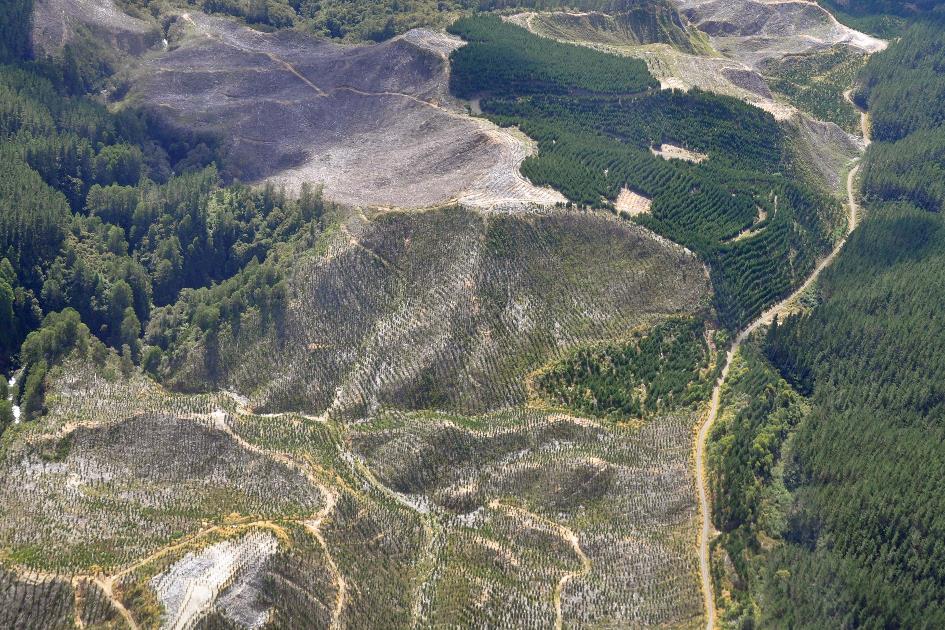
Thick pine forests line the Thermal Explorer Highway. Actually, they don't belong here because they are plantations of the pinus radiata. Normally, you only find it in the vicinity of Monterey in California. Nowadays, you find it everywhere in New Zealand – even in places where the Kiwis would rather not see it.
In the past, it was the native kauri that dominated the landscape of the North Island. These are gigantic trees – 40 to 50 m high, with a diameter of up to five meters. The wood of kauri is strong and easy to work with. They can, therefore, be used in various ways.
But the kauri has a significant disadvantage – it takes an average of eight hundred years to reach full maturity. New specimens are not readily available. As long as logging was limited to Māori who occasionally made a canoe out of it, that was okay. But once Europeans began using it for ship masts and homes from 1820 onwards, all hell broke loose. It is estimated that since then, 95 % of the kauri forests have disappeared.
An alternative was quickly found. The famous Monterey pine proved to do exceptionally well here. And what's more, it is ready for logging after just twenty-five years. Planting of the Monterey pine began as early as 1859. Nowadays, it makes up 89 % of all plantations.
In short, a piece of New Zealand as it always should have been
Waimangu
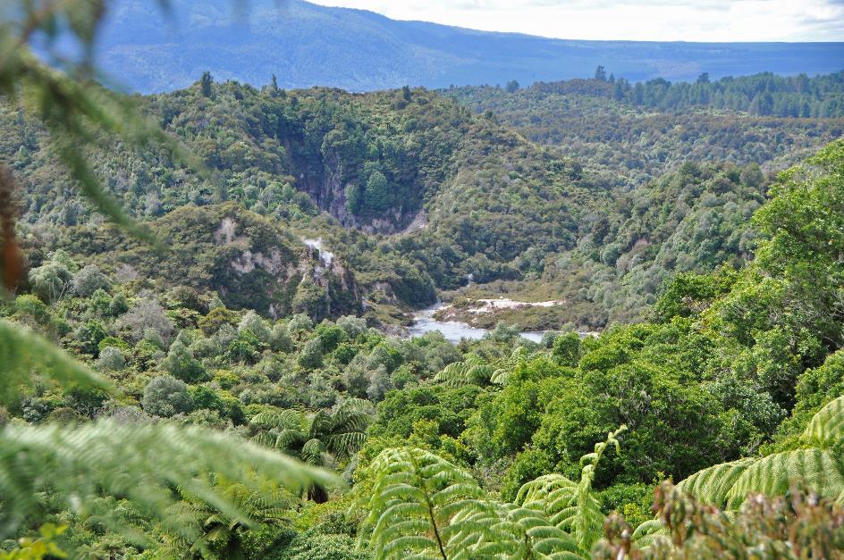
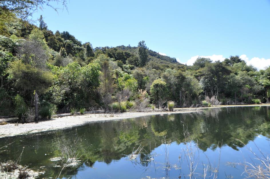
Just before noon, we are dropped off at the Visitor Centre of Waimangu. From an elevation of 460 meters, we survey the vast surroundings. It looks like a tropical rainforest from above. Lush greenery has completely taken over the hilly terrain. There are no bare spots; tall trees and ferns dominate the scenery. Without exception, they bear the signature of native flora. In short, a piece of New Zealand as it was meant to be. And they take great pride in this landscape reserve.
How the world began is the slogan they use to entice visitors here. And it's not even far-fetched because the origin of this area does trace back to a big bang. Specifically, the eruption of Tarawera on June 10, 1886. It must have been a tremendous explosion, with a column of fire, smoke, and ash reaching ten kilometres high. The earth was torn open over a length of seventeen kilometres, creating a deep chasm now known as the volcanic valley of Waimangu.
Several settlements in the vicinity disappeared under a layer of volcanic ash, mud, and debris, averaging twenty meters thick. One hundred and fifty people lost their lives. All forms of animal and plant life in the wide vicinity were smothered. What remained was a desolate, lifeless area.
Gradually, nature restored itself without any human intervention
Exactly there, our story begins. Because the inhospitable area was left to its own devices. Gradually, nature restored itself without any human intervention. Traces and seeds relied on birds and wind for dispersal. Over the past century, new vegetation developed. It was not an easy process, given soil temperatures up to 55 °C (131 °F) and hot springs with an acidity of up to 3.8. The fact that the environment was periodically disturbed by new eruptions didn't help either.
After lunch, we set off. We will descend through the volcanic valley to Lake Rotomahana, the lake that formed halfway through the gorge. At the bottom, a van will pick us up to take us back up.
Sky Father Rūaumoko |
|
Silver Fern – Top and Bottom |
Rūaumoko is ready to bid us farewell. Fortunately, because he is the Sky Father who oversees earthquakes and volcanoes. Under his protection, nothing can happen to us in this strange world.
It's going to be a journey of four kilometres, mostly downhill. What they call a hiking trail here turns out to be a super-luxurious gravel boulevard, more than a meter wide. It will be our first encounter with the excellent hiking infrastructure of this country.
What they call a hiking trail here turns out to be a super-luxurious gravel boulevard, more than a meter wide
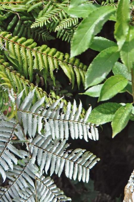
And with the silver fern. At first glance, it seems like an ordinary, well-grown fern until you look at the underside of its leaves. They are silver-grey. This tree fern is found nowhere else in the world. To such an extent that it has become a national symbol and proudly adorns the shirts of the All Blacks, the national rugby team, among other things. The planes of Air New Zealand also proudly bear a koru on their tail fin. It's a stylized representation of the young, unfurling leaf of the silver fern, a symbol that simultaneously represents perpetual movement and a return to the origin.
Southern Crater – Emerald Sea
Soon enough, the first crater lake appears, Southern Crater, where the cool water of the Emerald Sea today takes on an olive-green hue. No volcanic activity is evident here; this crater has been quiet since 1886.
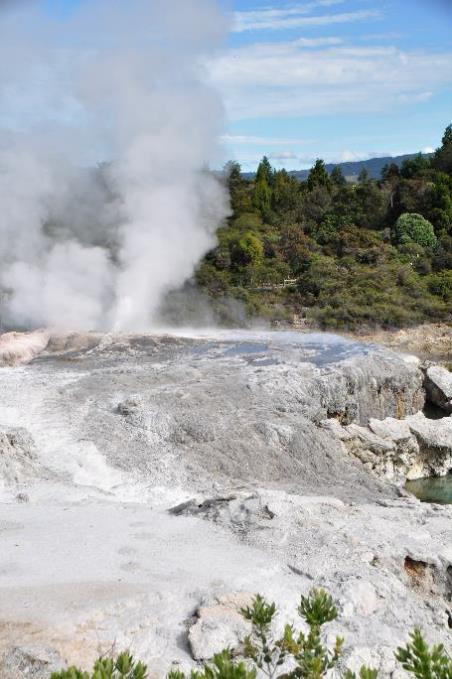
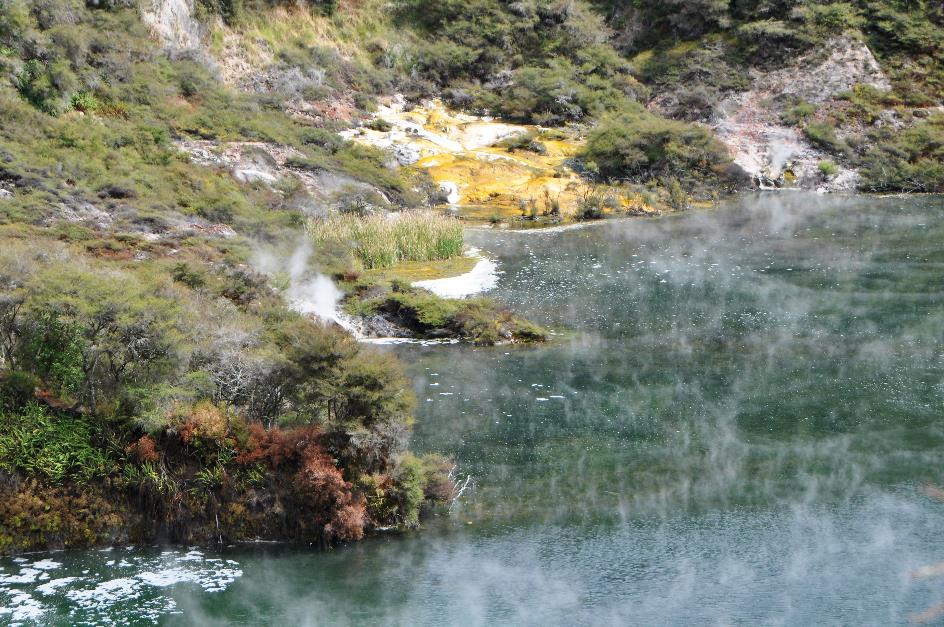
With its surface area of 38,000 m², Frying Pan Lake is the largest hot spring in the world
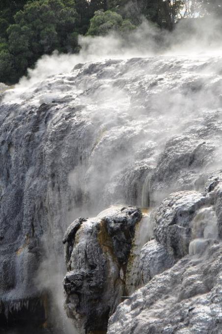
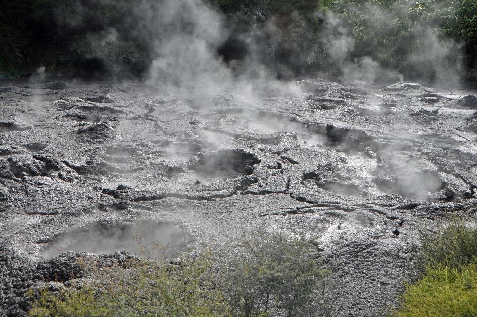
It's a completely different scene at Echo Crater. White wisps of mist curl low above the water's surface. In erratic circles, they slowly drift from the centre towards the shore. This is no ordinary lake; this is a colossal hot spring. With its surface area of 38,000 m², it is, in fact, the largest hot spring in the world.
Echo Crater – Frying Pan Lake
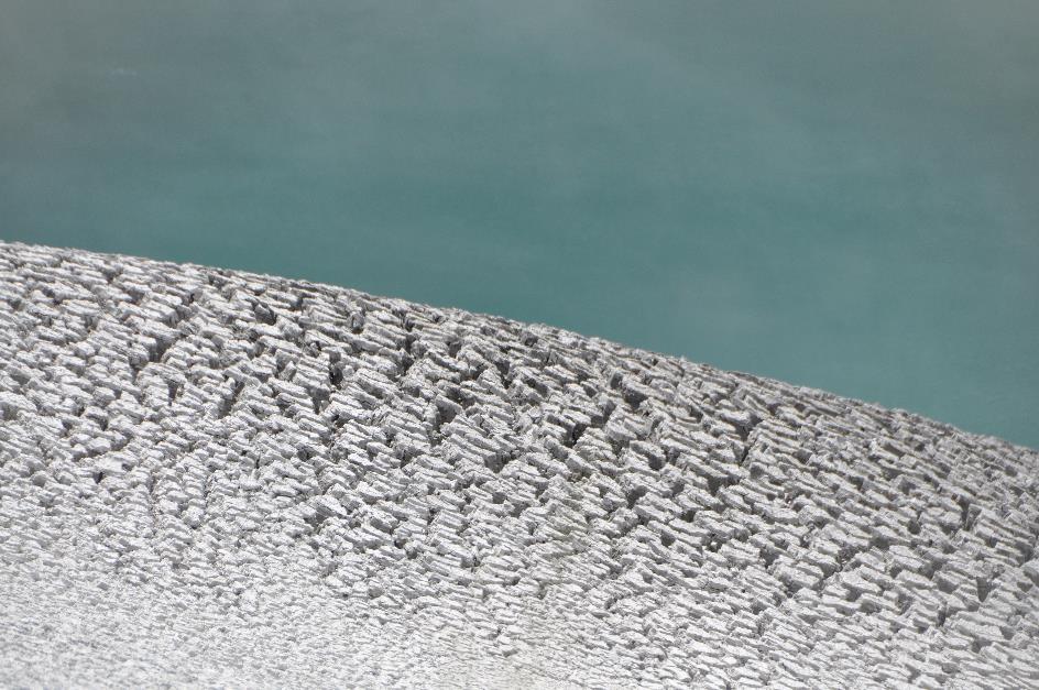
Plumes of mist rise from between the rocks. Amidst the birds' chirping, you occasionally hear the popping of gas bubbles on the water's surface. White and yellow sinter terraces are observable here and there on the shore. Algae are at work, depositing colourful silicon sediments. This, by the way, is almost the only form of life that can endure in this environment. The water temperature reaches up to 55 °C, and the acidity level is 3.5.
Barely ten years after the eruption of Tarawera, this crater was covered with volcanic dust. They called it Frying Pan Flat, the hot, sandy plain. Tourists liked to explore this bizarre environment – wearing snug Victorian outfits, as historical photos reveal.
The allure increased when, in the late 1900s, Waimangu emerged on the scene, the largest geyser humanity has ever known. When Waimangu was in good form, it spouted its black sludge 450 meters high into the air. Higher than the Eiffel Tower and the Empire State Building, proudly announces the information board. The geyser owes its name to that black sludge, as Waimangu means black water in Māori.
People from all over the world flocked to witness such a natural phenomenon, even in those days. Unfortunately, the joy was short-lived. On November 1, 1904, Waimangu had its last convulsion. Moreover, on April 1, 1917, an eruption destroyed the hot sandy plain. The crater that formed quickly filled with rainwater. Frying Pan Flat became Frying Pan Lake.
But it didn't stop there. Groundwater seeped five to ten kilometres deep into the porous rock. There, it heated up so much that it sought its way back up, carrying plenty of minerals along the way. That's how the hot spring we now gaze upon was formed. What the future holds, we do not know. The last eruption in this area dates back to 2016.
The last eruption in this area dates back to 2016
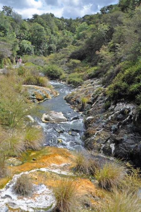
We now follow the Waimangu, the stream that springs from the east side of the lake. A wondrous world of scents and colours unfolds before our eyes. The steaming hot water cascades through bizarre silica formations and colourful mineral deposits. There are even traces of arsenic, molybdenum, antimony, and tungsten reportedly found here.
Blue-green algae thrive in this water. They are the ones producing the silica formations. Allegedly having a good time here is chloroflexus aurantiacus – a name to quickly forget. It's not unusual for this bacterium to feed on sulphur, but how it is capable of photosynthesis like plants still intrigues scientists.
With a temperature of 75 °C (167 °F) and a pH of 2.8, no form of life has any business in this water
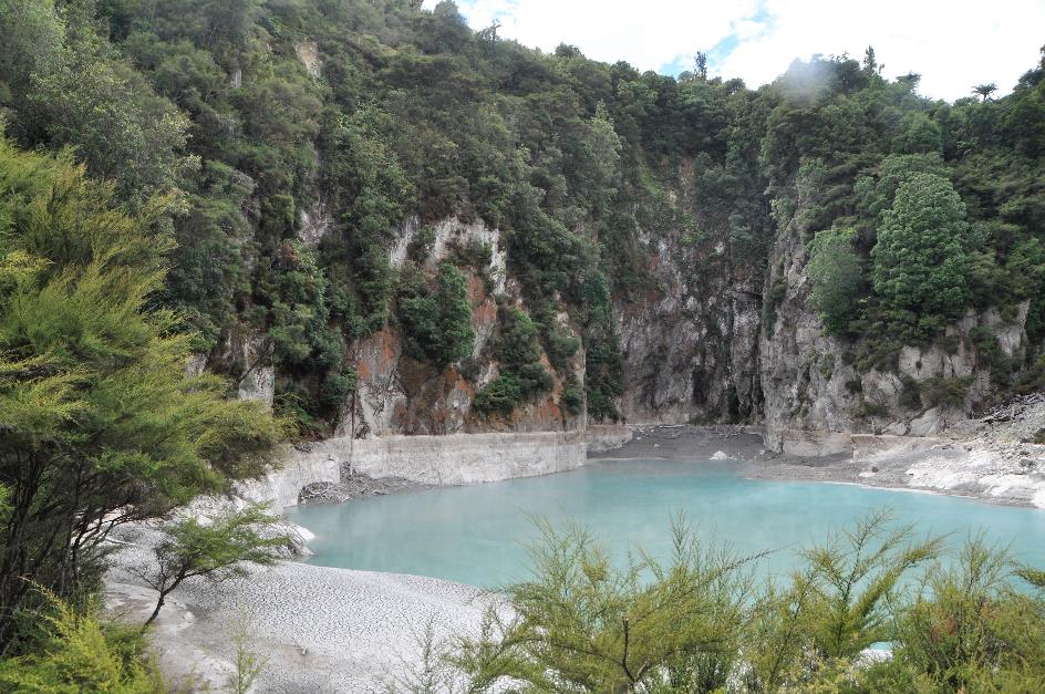
Inferno Crater
Next, we climb to Inferno Crater. From a safe height, we gaze down at the grey-blue water of the crater lake. Even amid the many wonders in this valley, this one is a unique case. While Frying Pan Lake deals with a lot of groundwater, the water here mainly bubbles up from the depths.
What's more, the water level rises and falls in a regular cycle. Currently, it's at its lowest point, hence the grey-blue colour. When the water rises, it sometimes dares to overflow the crater rim. Once it settles, it takes on that beautiful sky-blue colour for which Inferno Crater is famous, contrary to its name. An idyllic scene, indeed, but with a temperature of 75 °C (167 °F) and a pH of 2.8, no form of life has any business here.
Inferno Crater
Hot springs with brown algae
An exuberant sun reigns over the firmament. A few scarce clouds can't spoil the fun. Along the Waimangu, we continue strolling downhill. It remains a strange sensation, this comfortable gravel path. Almost like we’re sitting in a chair, it guides us through this ominous environment. As if humans could master nature. While it's just a matter of waiting for the next eruption.
Algae colour the water green. But just below the spray nozzle, the rock takes on an orange hue. Because even for the algae, it's much too hot right there
Bird's Nest Terrace
It looks like a tiny volcano, the cone-shaped nozzle that is active a bit further. Only about a meter high, the boiling hot water reaches before splashing into the river. Algae thrive on the minerals and give the water a green colour. But just below the spray nozzle, the rock takes on an orange hue. Because the algae don't dare to venture there. Much too hot, they think. Can't blame them.
The silicic acid deposited by the algae has accumulated into a circular terrace. The green basin that has formed has been appropriately named Bird's Nest Terrace.
Waimangu river |
|
Moss |
Moss
As the valley widens, more and more birds come into view. Challenging us on the muddy riverbank are two Australasian swamphens, also known as pūkeko. You can encounter them almost everywhere around here. Presumably, their ancestors flew over from Australia about a thousand years ago.
Waimangu River flows into Lake Rotomahana
With their bulky bodies on tall legs, long toes, and a thick red bill that extends into a horny plate on their foreheads, they leave little doubt – birds are the dinosaurs of our time.
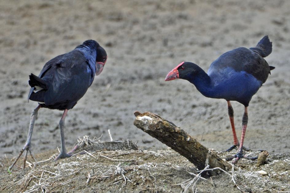
Birds are the dinosaurs of our time. These pūkekos or purple swamphens leave little doubt about that
Pūkekos often live in a close-knit social group. Together, they defend the territory and raise the chicks. This extends to the point that they lay all their eggs in one nest, sometimes 15 to 18 at a time. They take turns incubating the eggs – both males and females.
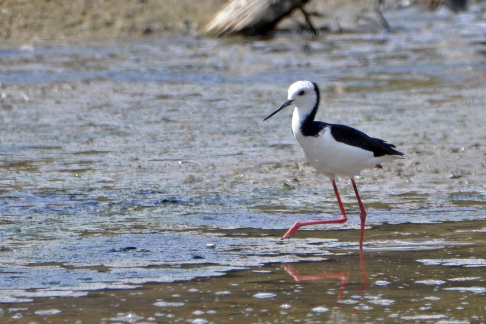
Pied stilt
Further along, an pied stilt wades through the shallow water. With its slender bill, long legs, and graceful body, it seems like the antithesis of the pūkeko. In the vicinity of a freshwater lake like Rotomahana, it feels at home, feeding on water insects, small molluscs, and larvae.
Pied stilts build their nests with mud and vegetation, sometimes entirely surrounded by water. This results in dampness in the nest, but it doesn't bother them in the least. They often form colonies of several dozen breeding pairs, sometimes in the company of stilts.
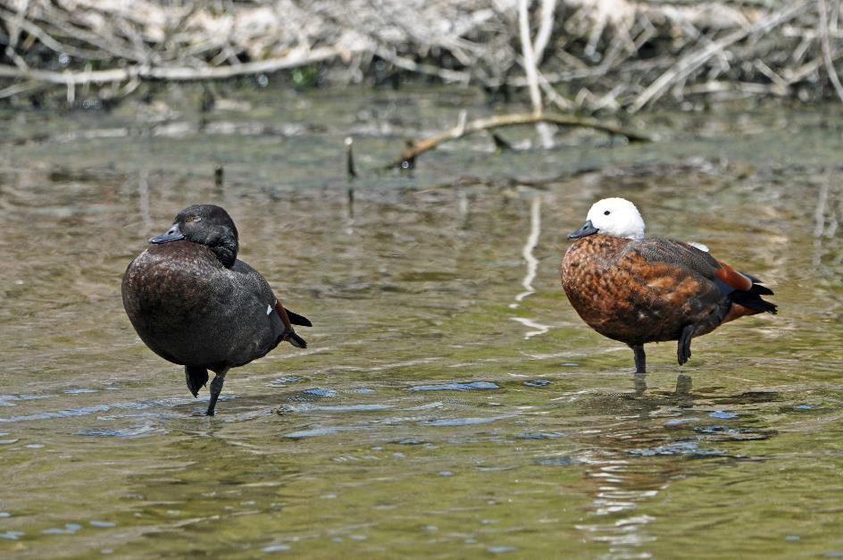
Paradise shelducks (m and f)
It's amusing to see two waterfowls dozing in the shallow water – each on one leg. They aren't ducks, nor are they geese. These endemic birds are somewhere between ducks and geese, and are called shelducks. Or paradise shelducks, to be more precise.
A beautiful bird indeed, especially the female with her chestnut-brown plumage and white head. They are monogamous and have pledged loyalty to each other for life. However, it occasionally happens that a cheeky bachelor thinks he's landed in Temptation Island and puts that commitment to the test.
Before the arrival of Europeans, paradise shelducks were relatively rare. Now, they are ubiquitous. You can even find them in city parks. It seems like the world turned upside down. The explanation is not hard to find. Farmers have converted forests into grasslands, expanding the habitat of these shelducks.
Before the arrival of Europeans, paradise shelducks were relatively rare. Now, they are ubiquitous. It seems like the world turned upside down
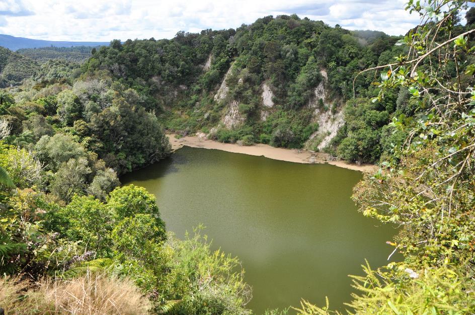
Soon, we reach the shore of Lake Rotomahana. It seems like an oasis of tranquillity after our encounter with so many geothermal phenomena. Some spots even give off a tropical vibe, with a white sandy beach and an obligatory palm tree under a radiant blue sky. Peeking from under the foliage, a tomtit surveys the surroundings, easily recognizable by the white streak on its black wings.
Lake Rotomahana – Beach
It was different once. Before the eruption of Tarawera, there were two small lakes here. However, the famous Pink and White Terraces drew all the attention. Tourists from around the world came to see these colossal terraces, which were then the largest silica deposits in the world. They were sometimes referred to as the eighth wonder of the world.
Only in 2011 were these sinter terraces located on the lakebed in the northeast corner. However, controversy surrounds this discovery, leading the Māori to be reluctant to grant permission for further research.
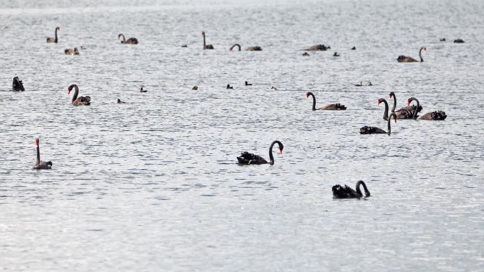
The lake doesn't have a natural outlet. Rainfall and evaporation determine the water level. But the many black swans in the area couldn't care less. They are abundant here, possibly introduced to keep the shores clean, as they mainly feed on water and marsh plants. Among the reeds, we spot a nest of black swans. Some fluffy chicks float on the water further away.
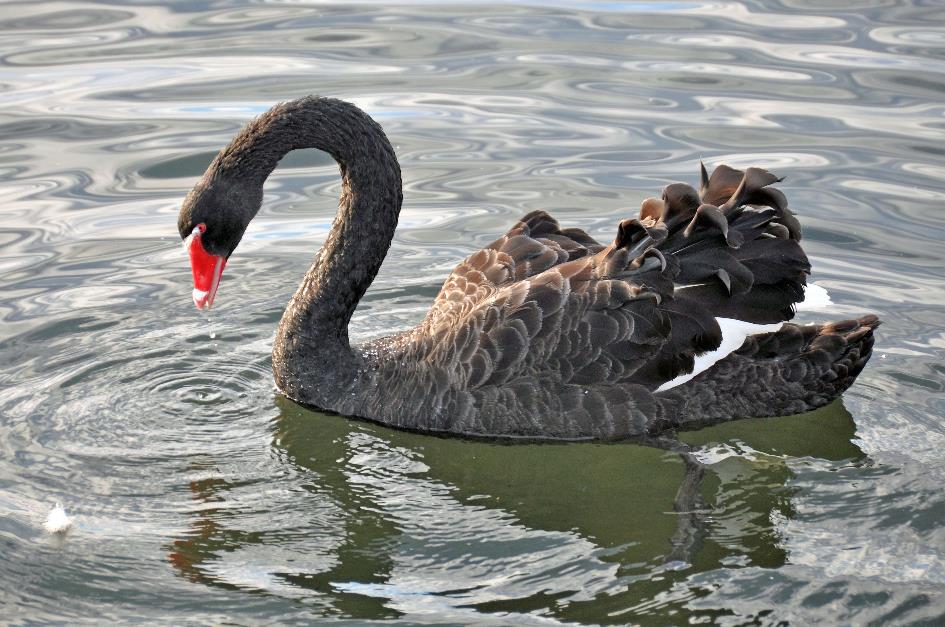
In the Middle Ages, a chaste woman was sometimes derogatorily called a black swan – a fictional creature, as black swans did not exist
In the Middle Ages, a chaste woman was sometimes derogatorily called a black swan – a fictional creature, as black swans did not exist, everyone believed. This gradually changed after Willem de Vlamingh, to his astonishment, encountered black swans in Western Australia in 1697. He named the river where this happened the Swan River. In the meantime, the city of Perth has developed along this Swan River.
Lake Rotomahana – Black swans
Black swans sometimes migrate, but there's no specific pattern to it. If they find a place no longer suitable – perhaps because it's becoming too dry – they fly elsewhere. In such cases, they don't hesitate to abandon their eggs or chicks outright, searching for a more humid environment.
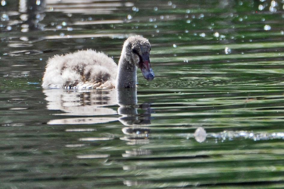
Black swan (chick)
Like other swans, the black swan is monogamous. About a quarter of the pairs are homosexual, often two males forming a couple. They steal eggs from another nest or temporarily form a trio with a female. They drive her away after she's done her part. They take care of the incubation themselves.
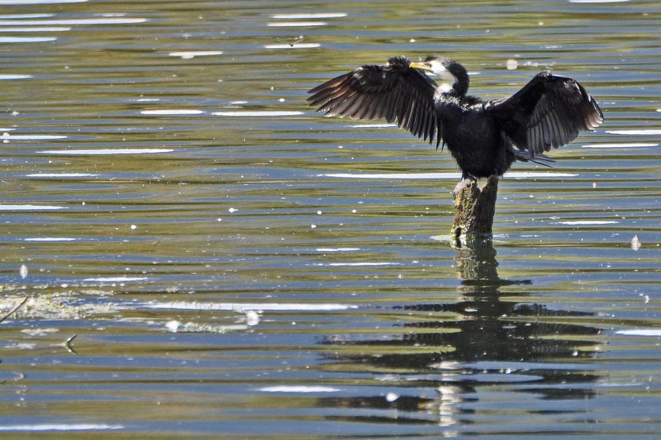
Little pied cormorant
Perched on a dead tree, a little pied cormorant sits with its black wings spread wide. Drying its feathers is routine for him. Every time he emerges from a dive, he's completely soaked. If he were to repel water like a swan or a duck, his plumage would be full of air bubbles. This isn't very practical when you have to dive deeply and for an extended period to gather your meal.
A van takes us back to the Visitor Centre. From there, we head to Rotorua, where we take a brief look at the old bathhouse. It's an impressive half-timbered structure, with beige gables and an abundance of dormer windows and turrets, all in Elizabethan style – Shakespeare would feel right at home.
Shakespeare would feel right at home
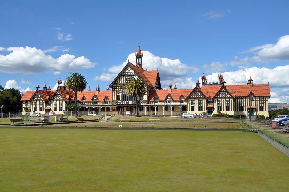
Great South Seas Spa
Attracting affluent citizens from the northern hemisphere was the explicit goal of the local government when they funded this prestigious project in 1908. The healing properties of the mineral-rich water from the thermal springs were unquestionable at that time. Patients could avail themselves of individual bathrooms and massage rooms – men on the left wing, women on the right. At its peak, the Great South Seas Spa enticed sixty to eighty thousand visitors per year.
In 1966, the facility was closed. Shielding the installations from the corrosive effects of the water proved to be a nightmare. Additionally, scientific doubt had arisen regarding the medicinal properties of the water.
Today, the Rotorua Museum is housed there. However, it is also closed for an extended period. Despite its beauty, the building doesn't comply with stringent earthquake security regulations.
For an introduction to the culture and customs of the Māori, we descend again to Te Puia just before six. What there is to be seen tonight, we will learn from Francis on-site.
We will be treated to a Te Whakarewarewatangaoteopetauaawāhiao. Sounds promising
Firstly, we will be treated to a Te Whakarewarewatangaoteopetauaawāhiao. Sounds promising. It turns out to be a war dance. Whenever Māori encountered an enemy in the past, they performed such a dance. Often, that was all it took to make the enemy flee immediately.
We, too, will be confronted with it shortly. Fierce Māori warriors will challenge us. If we can convince them of our peaceful intentions, Francis guarantees us a festive welcome. If not, he foresees a grim future for us. Sounds quite ominous.
Preparing food for a grand feast is what such hāngi was traditionally used for
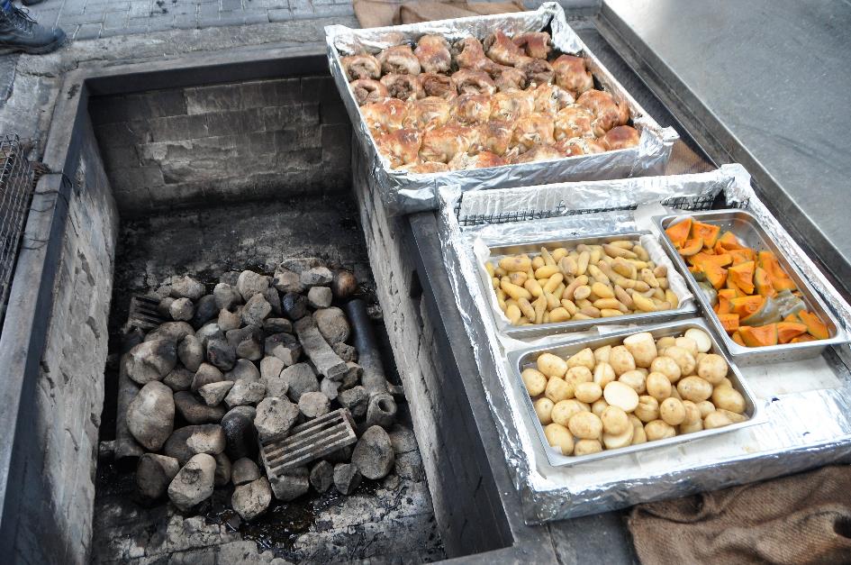
Te Puia – Hāngi
Francis gives us a glimpse into the pit where the food for that festive welcome is prepared. We peer down at a wire basket with two dozen cooked chickens and roasting pans full of potatoes, sweet potatoes, and pumpkins.
Preparing food for a grand feast is what such hāngi was traditionally used for. Hot stones were placed at the bottom of the pit oven. Baskets of food were placed on top, covered with bark and large leaves. The entire pit was covered with earth and left to its own devices for five to six hours. In principle, the food was then cooked.
The Māori must have brought this technique from their homeland because the oldest traces of such pit ovens date back to 1280. Never archaeologists have found a pit oven that was used more than once or twice for a hāngi.
Nowadays, things seem to be a bit more hygienic and efficient. The walls of the pit are constructed with stones, aluminium foil and stainless steel have replaced vegetation, and a metal lid shields the pit. In two to three hours, the ingredients for our feast are ready.
Half-past six. The ultimate confrontation is imminent. A large group of tourists – probably around two hundred – gathers in front of the marae, the open space where the ancient meeting house, the wharenui, is located. This is a sacred place for Māori society, the centre of their cultural experience. Every ceremony of significance takes place here, including the welcome ceremony, the pōwhiri, that awaits us.
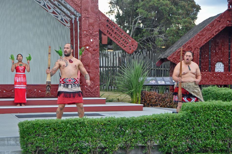
Pōwhiri on the porch of the wharenui
Warriors in traditional loincloths, with tattoos on their arms and legs, now appear on the porch of the wharenui. Trumpets blare, fierce cries resound, and the wooden floor vibrates under their stomping feet. One of the warriors takes the challenge to the extreme. With a ceremonial weapon at the ready, he charges towards us. We keep quiet. You never know if he means business. And we still want something to eat.
The new understanding is sealed with a hongi, a double nose greeting. We are no longer considered strangers
But everything turns out well. Our group is accepted. The new understanding is sealed with a hongi, a double nose greeting between the warrior and a representative of the tourists. This way, the symbolic exchange of the breath of life occurs between them, and we are no longer considered strangers.
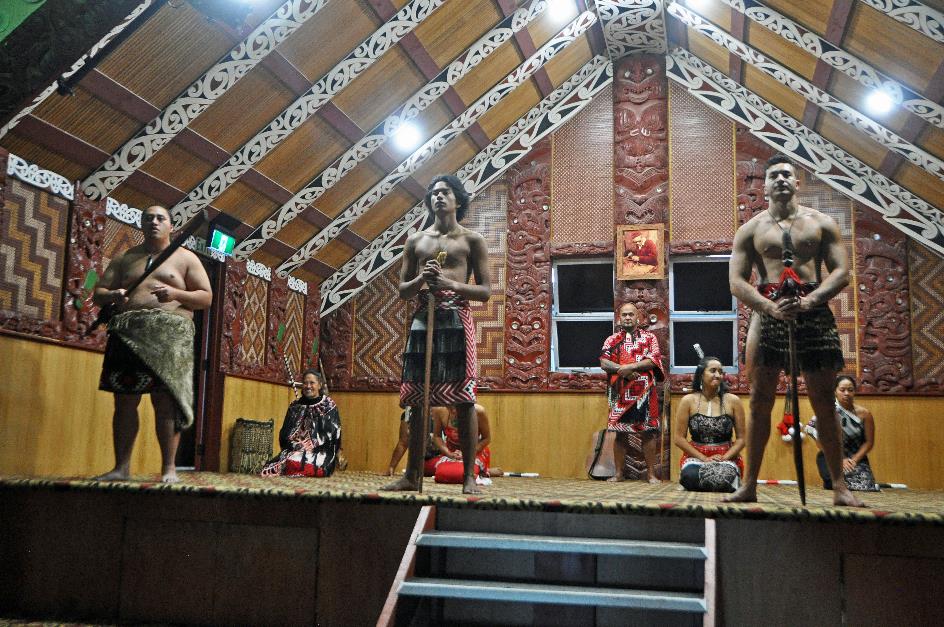
Māori songs and dances
Relieved, we enter the wharenui. It is an impressive display of wood carving. Eleven dancers perform Māori songs and dances for us.
But, of course, we are all eagerly anticipating the haka. These dancers do not disappoint. It becomes an impressive spectacle; they leave no part of their bodies untouched. Their faces contort into the strangest grimaces, their hands slap wildly against their bodies, their feet energetically stomp on the stage, their voices sing, shout, call, and groan. Then there are those rolling eyes, with irises that seem to swim in a sea of white, not to mention the long, challengingly extended tongue – a gesture strictly reserved for men.
The haka owes its international fame mainly to the All Blacks, the national rugby team that performs the dance before its international matches – a tradition that has since caught on with other sports teams in New Zealand. Surprise, disbelief, and hilarity are often the reactions of the foreign audience.
Then there are those rolling eyes, with irises that seem to swim in a sea of white, not to mention the long, challengingly extended tongue
Māori songs and dances |
|
|
It's often called a war dance, but that's a misconception. Depending on the nature of the event, there is a specific haka for each occasion – for welcoming a high-ranking guest, paying tribute to a great achievement, or mourning the loss of a valued person. Even in schools, performing haka is practiced as a cultural leisure activity, comparable to a choir or drama club in our schools.
Satisfied, we descend to the wharekai, the traditional dining hall. There, we find the simple yet nutritious ingredients of the hāngi awaiting us. However, they are supplemented with a rich offering from the Western kitchen, with flavours familiar to our taste buds. You can't say they don't know their stuff here.
Jaak Palmans
© 2024 | Version 2024-01-31 14:00
Continue reading in (3/11)
1) On December 9, 2019, an explosive eruption occurred on White Island, releasing steam and fragments of volcanic rock. The smoke plume reached a height of 3.7 km. Of the 47 individuals present on the island, 22 lost their lives. Almost all survivors, except for 3 individuals, suffered severe burns.