Giant beehives in the bush
Australia | Anno 2008
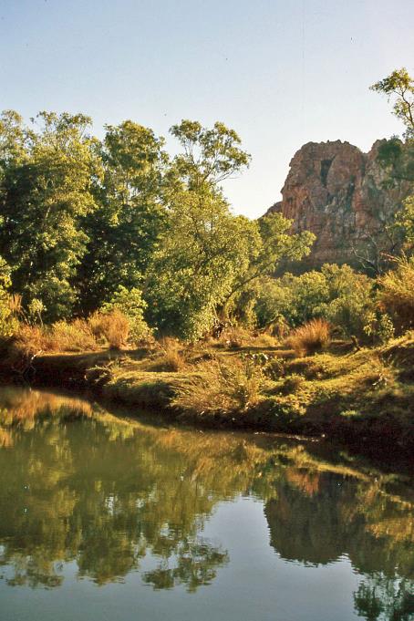
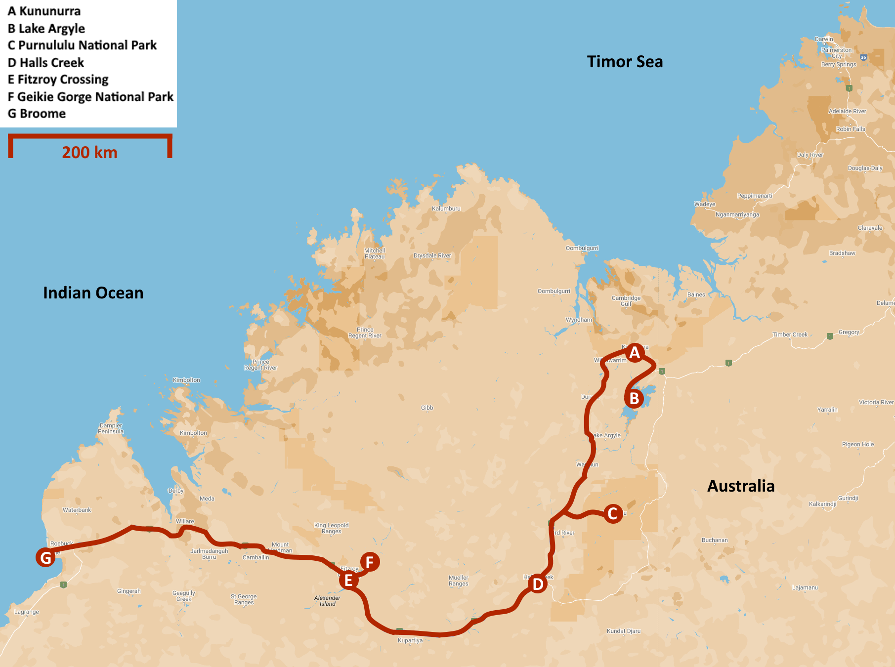
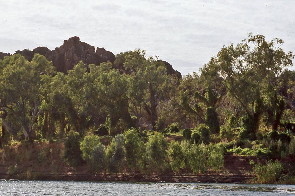
Thursday, August 7 | Kununurra
Friday, August 8 | Kununurra – Purnululu
Saturday, August 9 | Purnululu
Sunday, August 10 | Purnululu – Fitzroy Crossing
Monday, August 11 | Fitzroy Crossing – Broome
Thursday, August 7 | Kununurra
Our journey through the Kimberley has reached a turning point. Over the past week, we have traversed this fascinating wilderness from west to east via Gibb River Road and explored its northern part. Tomorrow, we will begin the return journey, directing our attention mainly to the south, as the absolute highlight of the tour is still ahead.
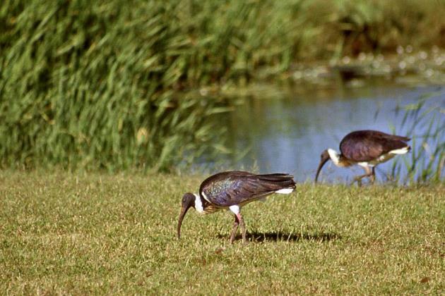
Straw-necked ibises |
|
|
But today is a day of rest. Driver and tour guide John has a day off. So, we have plenty of time to get acquainted with Kununurra. However, it's not straightforward, as you can easily end up walking for kilometres. It was a pleasant surprise last night when fellow travellers Ernie and Margaret suggested exploring the main attractions together. We couldn't resist that offer because they have a 4wd.
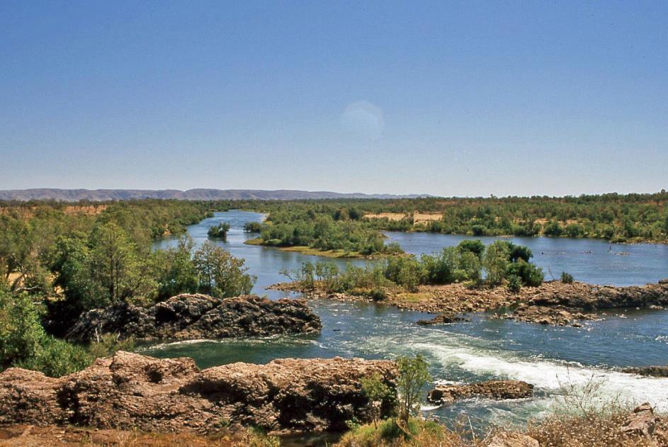
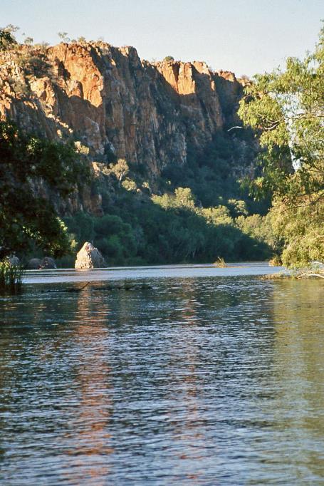
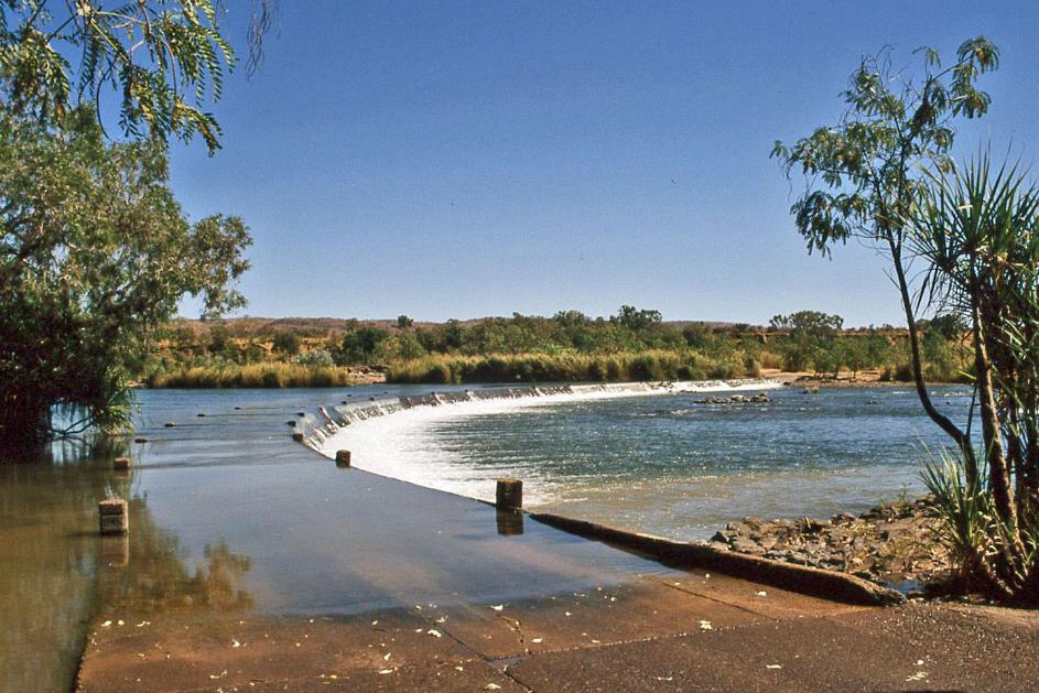
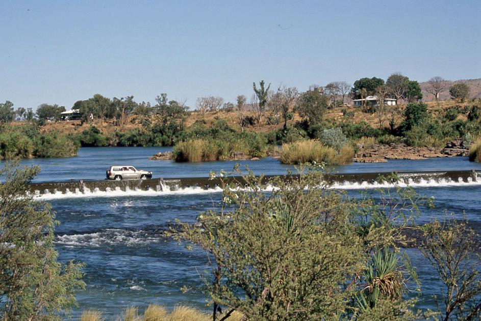
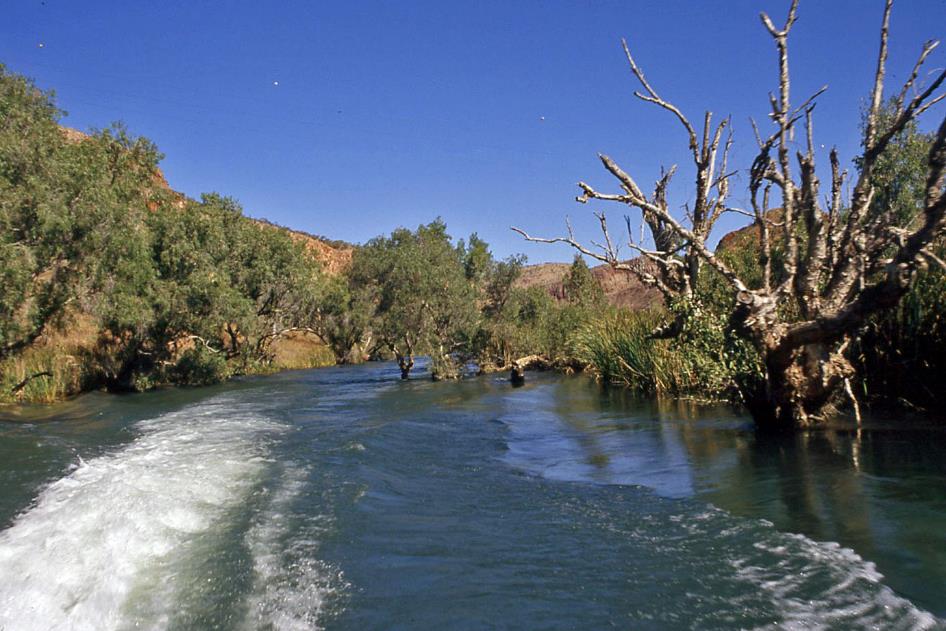
Ord River
You could call Ernie and Margaret true grey nomads. They have embraced the nomadic life for eighteen months, touring with their caravan across this vast country. For many retired Aussies, it's a dream come true. Ernie and Margaret enthusiastically participate, even though they haven't exchanged their British passports for Australian ones yet. Their caravan is parked at a holiday park on the outskirts of the city. For them, the tour through the Kimberley ends here.
Ord River – Ivanhoe Crossing
With a comfortable 29 °C (84 °F) ahead, our day looks promising. Ernie appears punctually at 9 a.m. with his Nissan Patrol. We promptly head to one of Western Australia's iconic spots, the spectacular Ivanhoe Crossing. Essentially, it's nothing more than a concrete causeway, a few meters high and nearly two hundred meters long, where the water of the mighty Ord River flows over.
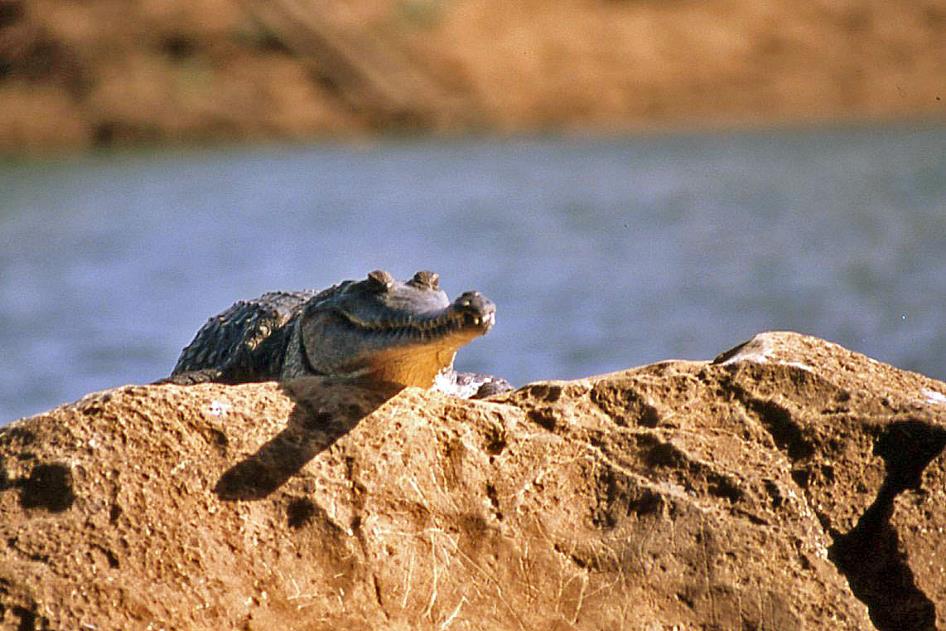
Nothing extraordinary, except that the causeway is part of the old road from Kununurra to Wyndham. Vehicles wanting to cross the river here must navigate through the fast-flowing water, and this is only possible during the dry season. Small concrete posts mark the route on both sides. Certainly not for the faint-hearted. During the wet season or with a regular car, it's not even worth attempting. Swimming is out of the question here, and even anglers should be cautious where they cast their line, as saltwater crocodiles are regularly spotted in these salty waters.
Ord River – Ivanhoe Crossing
In the irrigated fields, you mainly find extensive plantations of mango trees or sandalwood. The wonderfully fragrant sandalwood, which can retain its aromas for decades, is actually a parasite, Ernie explains. Just like mistletoe, it needs a host tree to obtain water and minerals.
The wonderfully fragrant sandalwood is actually a parasite. Just like mistletoe, it needs a host tree to obtain water and minerals
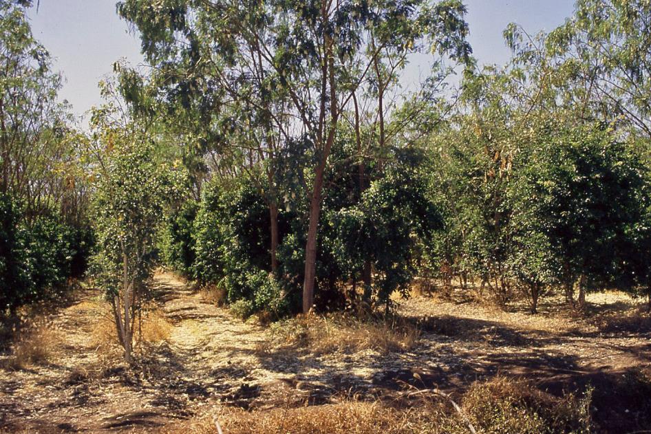
Sandalwood plantation
They are just harvesting the melon crop in a melon field. A mobile canopy shelters the pickers from the scorching sun. Fresh from the field, all these products quickly find their way to customers in the farm's own store. Ernie particularly recommends the tasty and nutritious flesh of the small Jarrahdale pumpkin. The butternut squash is a variant of it.
But our attention quickly turns to Catherine from the German town of Flensburg, near the Danish border. Originally, she had a one-year stay in mind when she moved to Australia, she spontaneously tells us. Meanwhile, her decision is firm – she is staying here permanently. By profession, she is a Küchenchef (chef), and in Germany, she worked in a few restaurants. But here, she finds the work much more pleasant – much less stress, always fresh produce available.
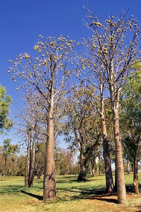
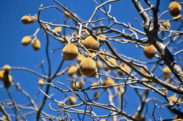
A few baobabs bear their distinctive fruits like Christmas baubles on their bare branches
Baobabs |
|
Fruits of a baobab |
Celebrity Tree Park is the place where every celebrity visiting Kununurra is allowed to plant a tree. It's not surprising that so far few celebrities have managed to grace this remote place with their presence. Some baobabs carry their typical fruits like Christmas baubles on their bare branches. Lily Creek Lagoon, on the other hand, is a paradise for birds. Among the water lilies, some jacanas with a distinctive red comb forage over the water surface. They are Australian jacanas, found in northern Australia as well as in Indonesia and the Philippines. They are sometimes called Jesus birds, according to Ernie, but he doesn't know why. Apparently, he is unaware of what might have happened on the Sea of Galilee.
It's half past eleven when Jeff arrives with his bus in front of our hotel. Because this afternoon, we have a bus trip to Lake Argyle in mind, followed by a boat trip on the Ord River. Triple J-Tours, we read on the side of his bus. We will soon find out that Jeff is one of those three J's. It's not far, only 35 km as the crow flies. But the rugged nature forces us to take a detour of 70 km. We don't have to worry about boredom on the way; Jeff seems ready to talk the entire journey.
It took a lot of deliberation before they knew what kind of agriculture they were going to practice in Kununurra
It took a lot of deliberation before they knew what kind of agriculture they were going to practice in Kununurra once they had made the arid land fertile. Cotton was the first option, but it soon proved to impose too much strain on the water resources. Rice was the next choice since having Indonesia in your backyard provides a massive market. However, white farmers were not well-versed in rice cultivation. Sugarcane was the next attempt, inspired by what they do in Queensland. Unfortunately, sugarcane prices collapsed. Eventually, they turned to fruit cultivation – melons, mangoes, and the like, concludes Jeff.
Since the irrigation project with water from the Ord River started in 1963 – incidentally in the presence of Queen Elizabeth II and Prince Philip – around 160 km² of farmland in the vicinity of Kununurra has been irrigated. Those are the green and yellow rectangles we saw last night, flashes through our minds. Additionally, there's another 360 km² ready for irrigation.
Water for irrigation is by no means expensive here. For one megalitre – one million litres – you pay just under two euros. Per hectare, you need 6 to 8 megalitres annually, including equipment, costing you 86 euros per hectare per year. Jeff is a man of numbers, that much is clear.
A stone's throw from the border with Northern Territory, Jeff takes the turn towards the lake. If you want to cross this internal border, you are subject to strict quarantine rules. Your vehicle must not have any soil, seeds, or plant material on board – not even on the tires or the bodywork. Noticeable mistletoes adorn the bare trees at the intersection.
Since the irrigation project started in 1963, around 160 km² of farmland in the vicinity of Kununurra has been irrigated
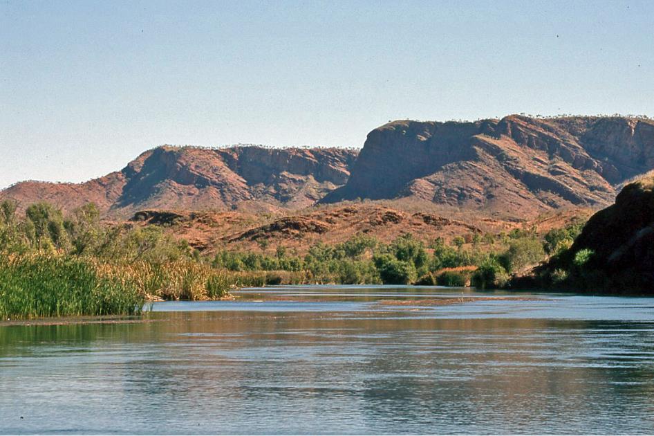
Gradually, we approach Lake Argyle, the crowning achievement of irrigation projects in the surrounding area, with an area of almost a thousand square kilometres. Impressive, indeed, but what really surprises us is the influx of water during the rainy season. Sometimes, the water level of the lake rises by more than one meter per day. With that, you could supply the city of Perth with its one and a half million inhabitants with water for five years, emphasizes Jeff. And so far, we've experienced the Kimberley as extremely dry.
Normally, 70,000 litres of water are drawn from the lake every second. As a result, the water level drops by just over 2.2 meters per year. Evaporation adds another 2.5 meters to that. Jeff is a man of numbers, that's clear.
And he's really getting into it now. The water stock in the lake fluctuates significantly depending on the season, he continues undisturbed. Currently, it holds only 22 Sydney Harbours, but the record is 37 Sydney Harbours. We don't have to worry about flooding, he reassures us immediately, because the basin can handle up to 68 Sydney Harbours.
Did we hear that correctly? Are they really using Sydney Harbour as a unit of measurement here? Yes, indeed, the sydharb is a popular Australian volume unit. It corresponds to the total amount of water deemed to be present in Sydney Harbour. As every Aussie should know, that's 500 gigalitres or 500 billion litres. We feel like ants trying to grasp the dimensions of a soccer field.
But Jeff is unstoppable. The current stock of 11,000 billion litres of water corresponds to 2,000 litres of water per capita of the world population. Jeff is a man of numbers, that's clear, but when it comes to the world population, he is a few years behind.
It took the caravan of 7,250 cows and 200 horses three years to complete the odyssey of 4,800 kilometres
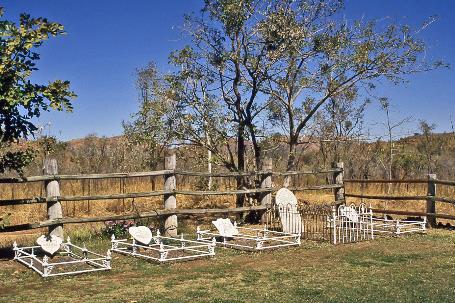
That hasn't prevented us from reaching the Durack homestead in the meantime, the place from which this illustrious pioneer family managed their estate. Although that's not entirely accurate. In fact, the original residence of the Duracks was located about twenty kilometres to the south. However, that area has since been inundated by the lake. Apparently, the wooden building was considered valuable enough to be dismantled and meticulously reconstructed at this location. This puts the Duracks on the same level as the Egyptian pharaoh Ramses II – he also had his abode in Abu Simbel relocated to a higher and drier spot due to expected water overflow.
Several authentically decorated rooms evoke the atmosphere of the past. The fact that the Duracks were the most important pioneering family in the Kimberley is undisputed. Patriarch Michael migrated from Ireland in 1853. But it was his son Patrick – or Patsy, as he is affectionately called here – who would put the family on the map. How he did it still captivates the imagination. From scratch, he established a farm in the southwestern outback of Queensland, Thylungra Station. He would have paid for that adventure with his life if Aboriginals had not saved him during a period of extreme drought. But Patrick persevered. Ten years later, his cattle herd numbered 30,000.
Yet, that wasn't enough for him. Pioneers had by then explored the remote Kimberley, and their reports sounded promising. Patrick couldn't be stopped. In 1879, he set out with his brother Michael and his brother-in-law John, accompanied by 7,250 cows and 200 horses. It took the herd three years to complete the 4,800-kilometer odyssey. When they arrived in Kununurra in 1882, they had lost half of their herd. Some men had also lost their lives. But once again, Patrick established a successful cattle ranch. Their heroic journey is rarely matched.
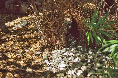
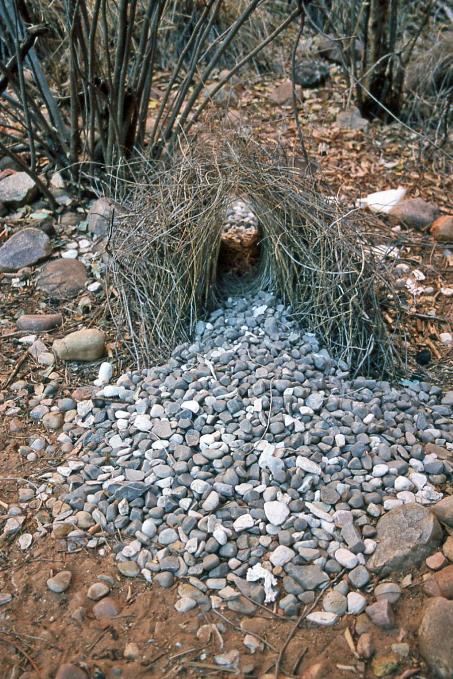
For males looking to court a female, it's all about building the most appealing bower
Durack Homestead – Tombstones |
|
Bowerbird nest |
In the garden of the homestead, some tombstones have been reconstructed. Our Australian travel companions find them quite intriguing as they attempt to reconstruct the family ties of their famous fellow countrymen.
For us, on the other hand, it's some peculiar bird nests that capture our attention. Bowerbirds have been at work here, a bird species found only in Australia and New Guinea. What makes them particularly unique is their courtship behaviour. For males looking to court a female, it's all about building the most appealing bower. They do this by placing bare twigs on the ground, leaning them against each other to form a kind of wigwam, complete with an entrance.
The finishing touch is a collection of objects of the most diverse nature, used to pave the entrance to their love temple. This can range from berries and flowers, shells and feathers, pebbles and leaves to household waste, glass shards, and plastic trinkets. The key is not what it is, as long as all objects share the same vivid colour, such as bright white, light green, or azure blue. The more objects you manage to collect, and the greater the colour harmony, the better your chances of enticing a female into your tent. However, males don't hesitate to vandalize a rival's bower or steal construction materials.
Jeff takes us up with his bus to a point where we can catch a glimpse of the lake. The enormous body of water stretches to the horizon. Yet, 99.5 % of the water surface remains hidden from our view. Oh well, numbers, Jeff can't resist.
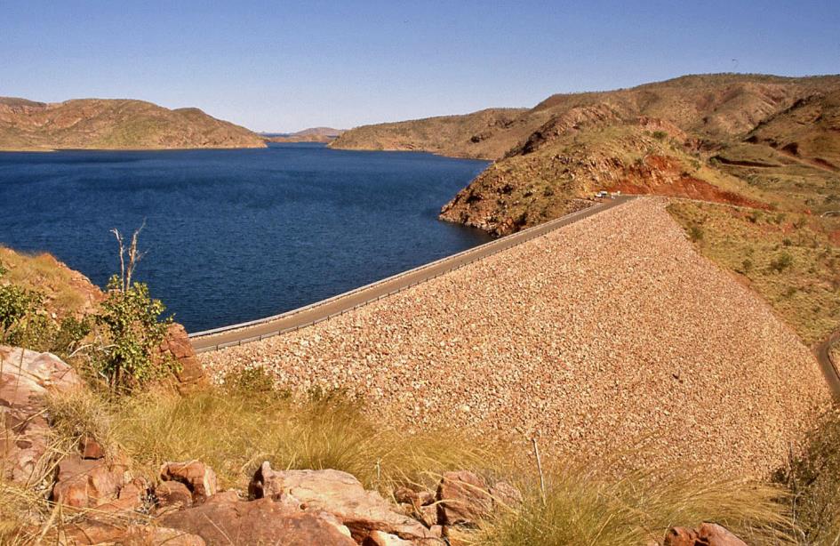
Ord River Dam, Lake Argyle
The Ord River Dam, on the other hand, surprises with the well-thought simplicity of its architecture. An impervious clay layer, covered with rocks, 68 meters long and 335 meters wide at the base, is sufficient to block all that water. The result is a structure that barely stands out against the bare mountains. Quite a feat of engineering, Jeff notes, and all for just 14 million euros.
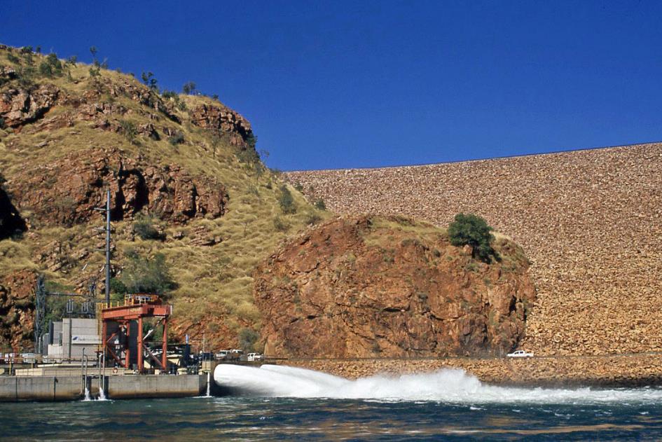
Ord River Dam – Hydroelectric power station
But there's more to it. Two tubes, each with a diameter of four meters, channel the water and drive the turbines. In total, 32 MW is generated here.
Even the local fauna and flora benefit. Where the riverbed used to be dry for most of the year, except for ten to twelve permanent water holes, there is now a majestic river with a constant flow in the landscape. Three species of turtles and 26 species of fish have made it their habitat.
By the way, the idea to build a large dam originally came from Kimberley Durack, a grandson of Patsy. Thanks to this massive lake, the farmers of Kununurra can count on a constant water supply.
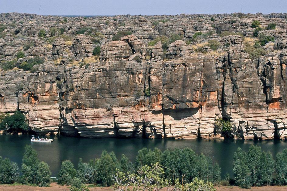
Ord River
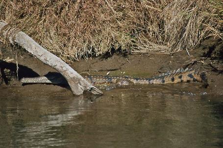
At the base of the dam, the Osprey awaits us. With Jeff as our captain, we will navigate the Ord River, 55 kilometres all the way to Kununurra. Along the way, a wealth of wildlife and plant life will unfold before our eyes.
Freshwater crocodile |
|
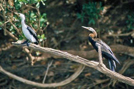
Australian pied cormorants |
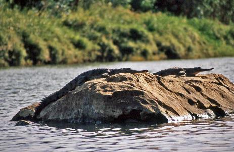
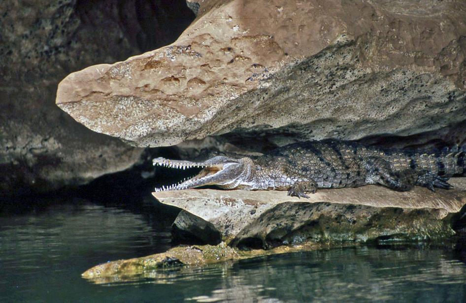
Starting with the freshwater crocodiles. An estimated five to six thousand specimens inhabit this part of the river. Jeff assures us that we'll certainly see some of them. Lake Argyle itself boasts a substantial population of freshwater crocodiles – around 25,000 individuals. However, saltwater crocodiles are not tolerated by the authorities. So far, they have removed eight from the lake.
Ord River
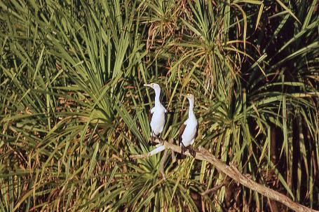
For now, we only spot pied cormorants, easily recognizable by the orange-yellow patch between their eye and beak. At the base of the rock wall, we notice two rock wallabies. However, they quickly flee as we approach.
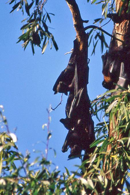
The flying foxes number in the hundreds, feeling secure in the branches of the trees that hang low over the water
Flying foxes |
|
|
Flying foxes, on the other hand, are entirely unperturbed by our proximity. Hundreds of them hang from the branches of the trees that lowly drape over the water. Jeff manoeuvers the boat just beneath the foliage, allowing us to observe them closely.
Ord River
We already knew from John that flying foxes feed exclusively on blossoms and soft fruits, so they don't rely on echolocation to find food. Instead, they have large adapted eyes to navigate at night. They only ingest the juice and small seeds from the fruit, spitting out the fibres, Jeff chuckles, as he swiftly moves the boat from under the trees.
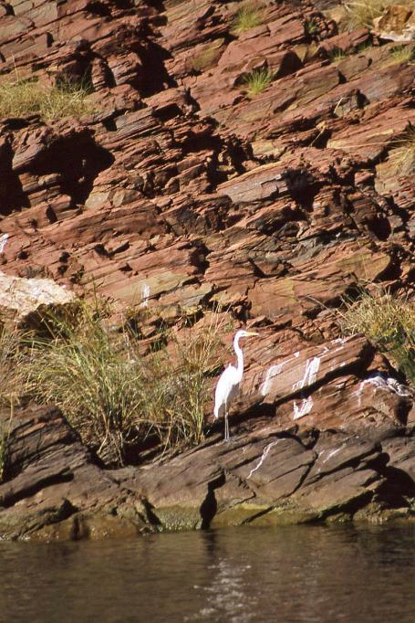
Great egret |
|
|
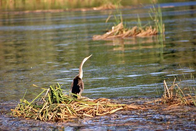
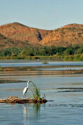
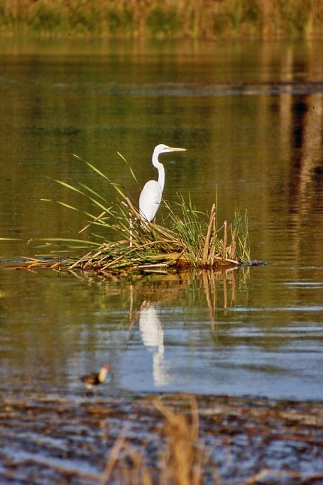
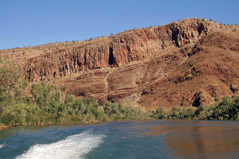
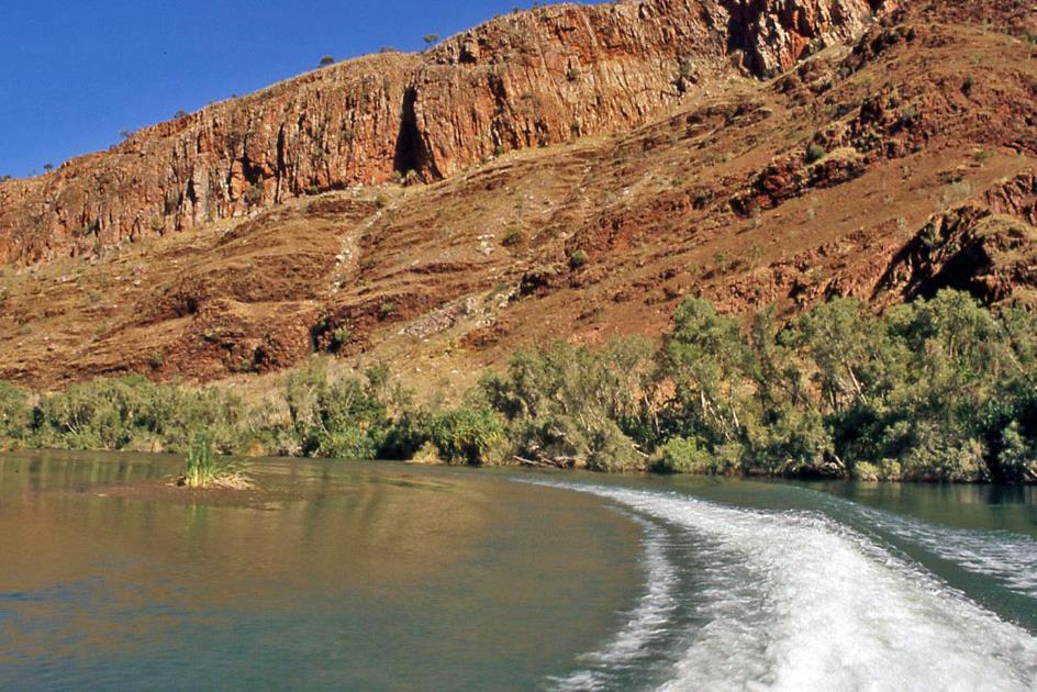
The brown-red, heavily layered rock formations around us descend steeply to the river. In the calm waters of Cooliman Creek, the lush tropical green is mirrored. Countless birds have taken their positions on tree stumps and rocks – great egrets, cattle egrets, pied cormorants, darters, pelicans. Occasionally, freshwater crocodiles can be spotted sunbathing.
Cooliman Creek |
|
|
On a tree trunk just above the river, a darter has built its nest. This is not a coincidence because when a seven-day-old chick attempts to spread its wings for the first time, it won't succeed immediately and will fall unharmed into the water. It will then swim to the shore, crawl back onto land, and find its way back to the nest in the tree.
Ord River
For our afternoon snack, we go ashore. In the midst of the wilderness, Triple J Tours has provided a clearing with permanent tables and benches. Coffee, tea, muffins, and scones make up our afternoon treat.
Countless birds have taken their positions on tree stumps and rocks – great egrets, cattle egrets, pied cormorants, darters, pelicans
Darter |
|
Great egret |
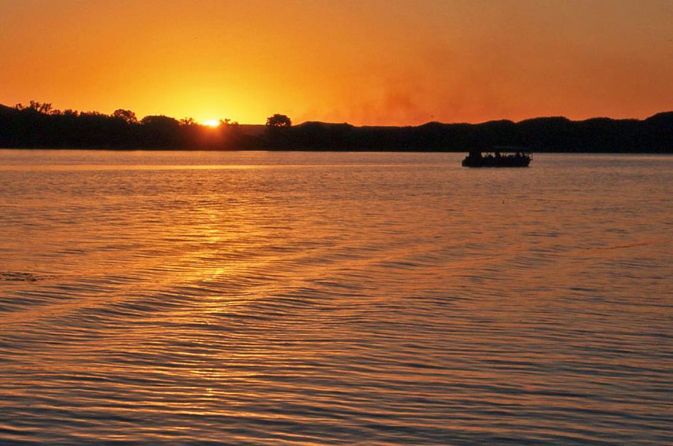
While in the west, the fiery sun slowly descends into the golden river, Jeff brings the boat to a stop in the middle of the river. Enjoying this sunset over the Ord River seems to be the grand finale of our river journey.
Great egret |
|
|
However, that's not the end of it. Jeff has another surprise in store for us. In the twilight, bats suddenly become active. Not just a few bats, as there is a colony of an estimated four million individuals residing here. All at once, they take to the sky, and for minutes on end, the reddish evening sky in a 360° circle around us literally turns black with bats. They fly around, screeching loudly, sometimes skimming past our heads, sometimes low over the water to scoop up some water. Meanwhile, several crocodiles lie in wait, jaws wide open, hoping that the echolocation of the bats occasionally fails them.
While in the west, the fiery sun slowly descends into the golden river, Jeff brings the boat to a stop in the middle of the river
Friday, August 8 | Kununurra – Purnululu
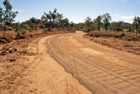
Just before seven, we leave Kununurra behind. Half an hour later, we already have the smooth asphalt of the Great Northern Highway beneath our wheels. Quite a contrast to the unpaved Gibb River Road. We take a short break at the Doon Doon roadhouse, and about an hour later, we stop at the Turkey Creek roadhouse, where John has to search for a replacement part for one of the lamps on our bush bus.
The unexpected bonus is that we can spend a considerable amount of time at the nearby Warmun Art Gallery. They have an excellent collection of contemporary works by Aboriginal artists. Depictions of stories from the Ngarrangkarni, the local version of the Dreamtime, are showcased, along with events from daily life. Definitely worth a visit, although Our Land Gallery in Kununurra remains unbeatable for us.
Corrugations in Spring Creek Track |
|
Mabel Downs Station |
It's half-past eleven when we reach the turnoff to Purnululu National Park. The comfort of the highway promptly gives way to the bumpy terrain of Spring Creek Track. Initially, it goes relatively smoothly over the private property of Mabel Downs Station. We have a quick lunch, setting a record for speed, and then continue our journey. The road doesn't improve. It winds through steep ridges and across creeks where the water is over half a meter deep.
For a moment, we are even delayed by a jeep that got stuck in the mud of Frank River, but eventually manages to free itself under its own power. This river marks the transition from Mabel Downs Station to Purnululu National Park. With its 2,397 square kilometres, it is about the size of the Grand Duchy of Luxembourg.
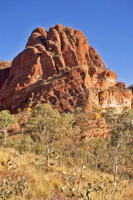
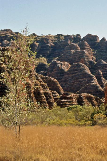
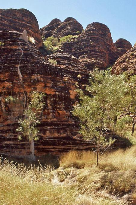
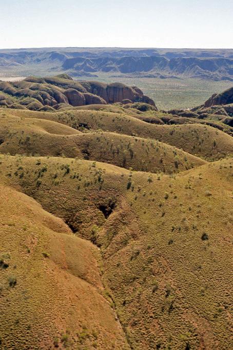
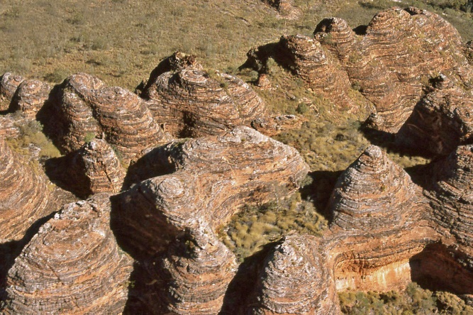
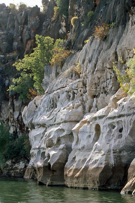
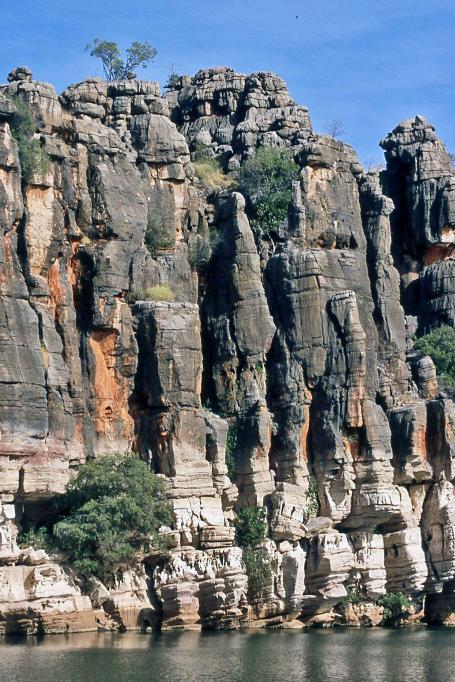
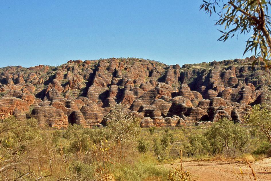
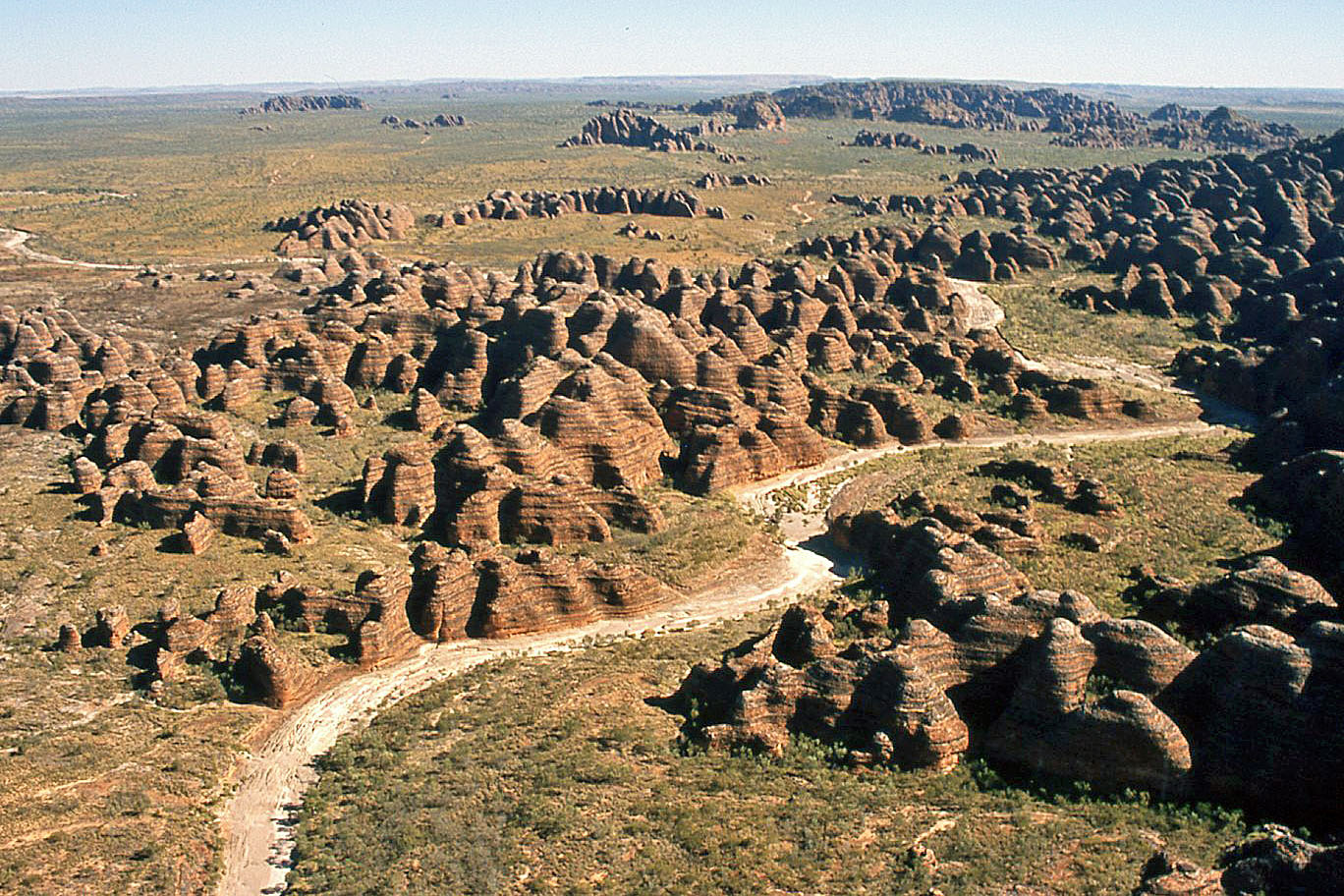
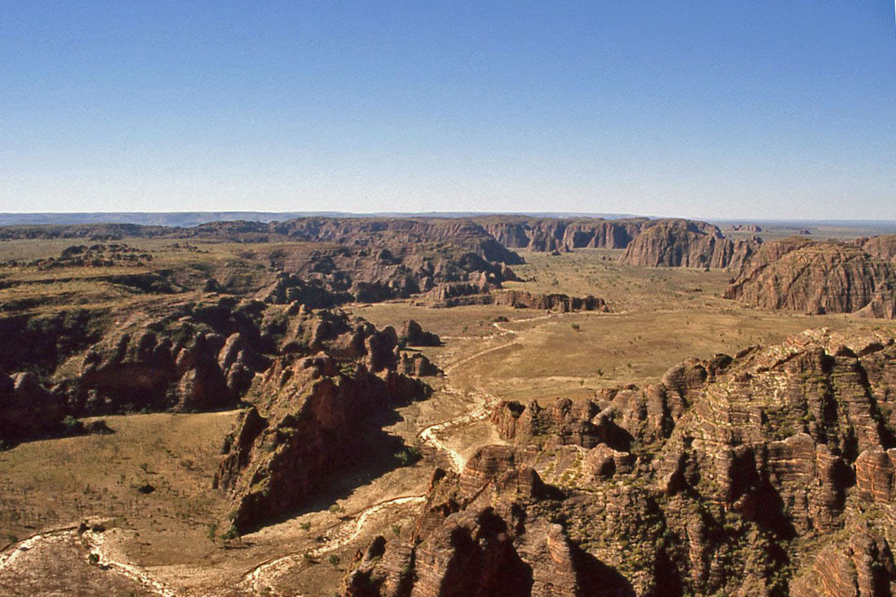
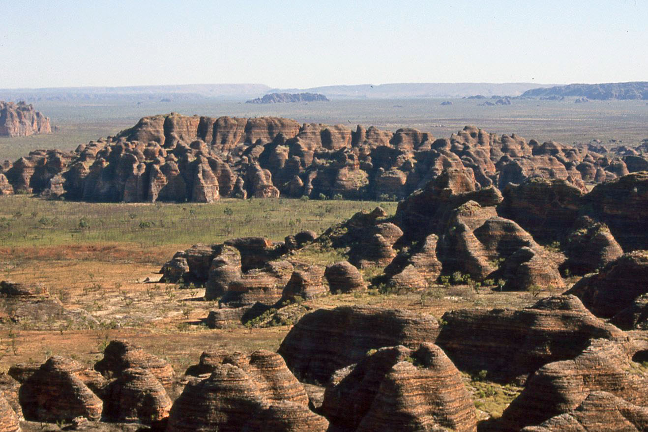
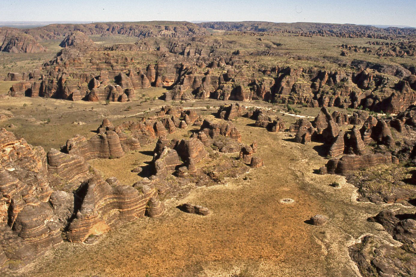
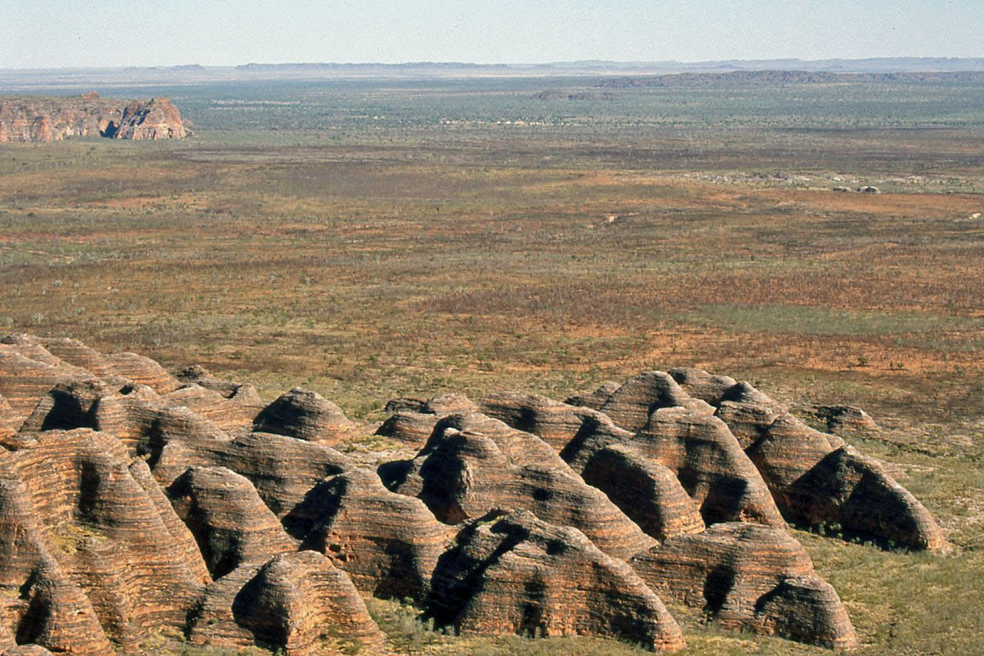
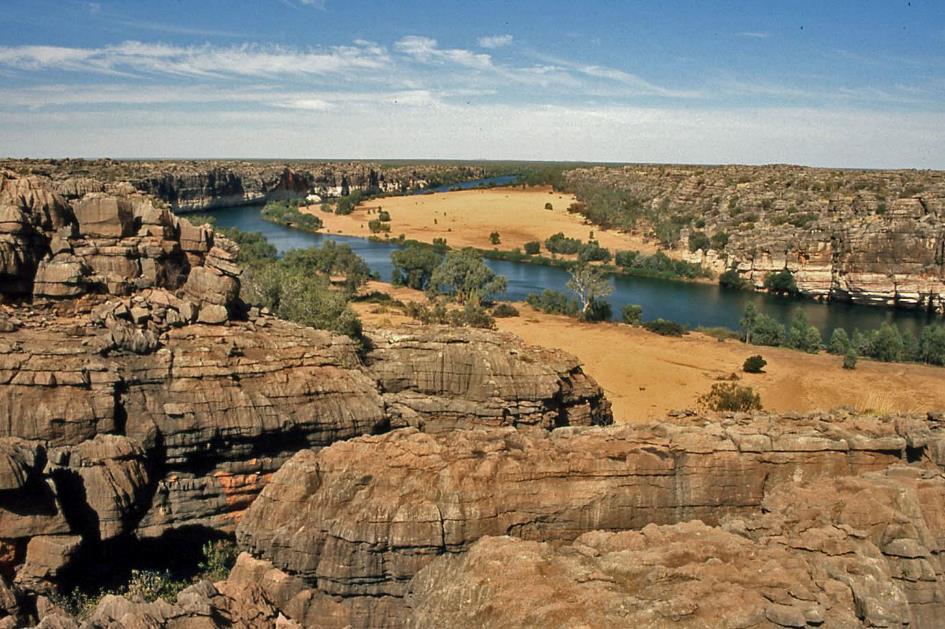
Like giant beehives, hundreds of sandstone formations rise from the bush – the tallest reaching up to 587 meters above sea level
Purnululu National Park – Bungle Bungle Range
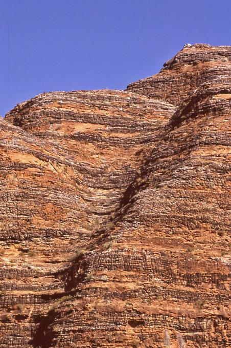
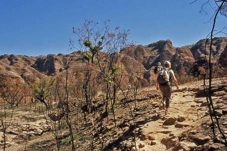
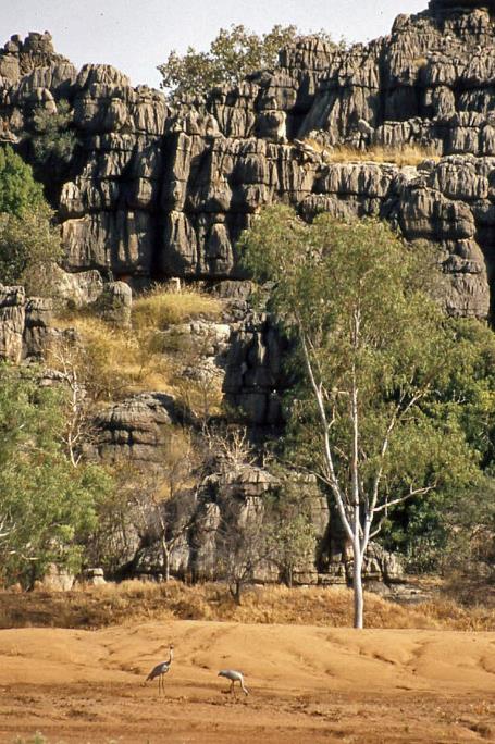
Annually, only about twenty thousand visitors find their way to this national park during the dry season. That's a little over a hundred per day. Not that it poses a problem for us – we practically have the enormous park to ourselves. Nevertheless, it's highly surprising because Purnululu boasts one of the most fascinating geological formations in Western Australia – the Bungle Bungle Range. Like giant beehives, hundreds of sandstone formations rise from the bush – the tallest reaching up to 587 meters above sea level.
|
|
|
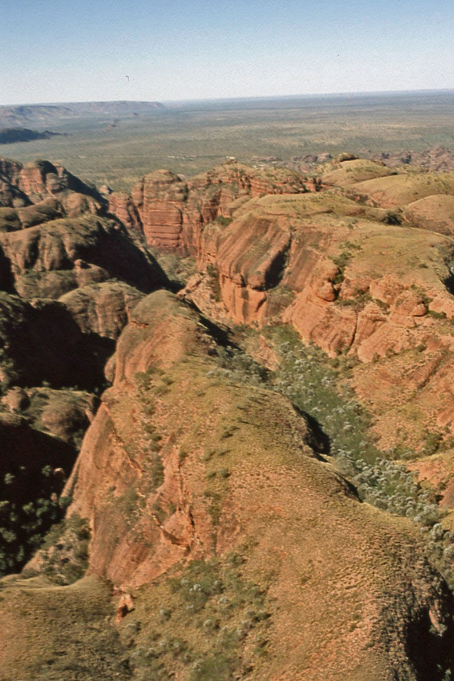
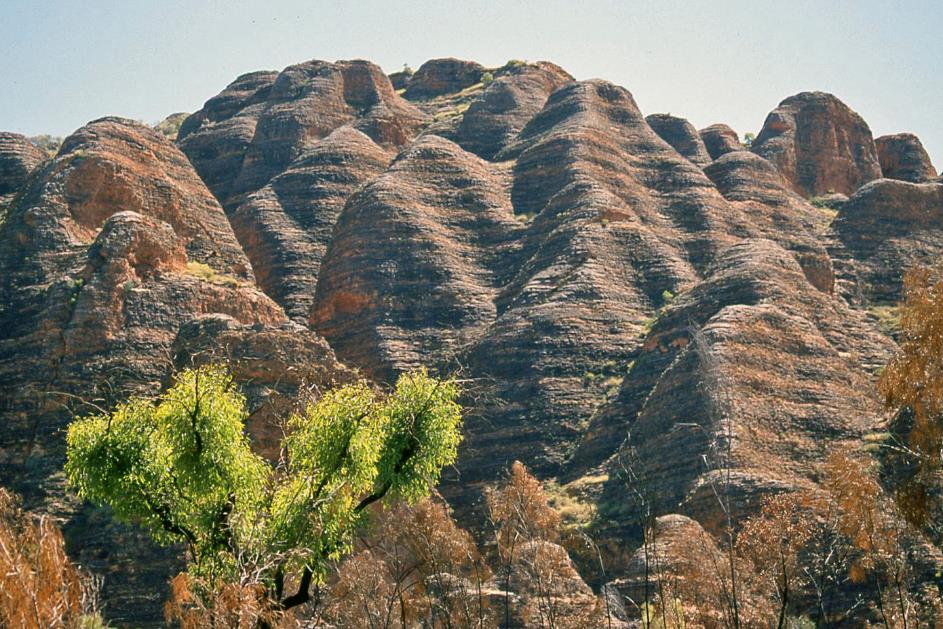
Where the sandstone contains iron, the hues of yellow, red, and brown emerge, giving the gorge a breathtaking array of colours
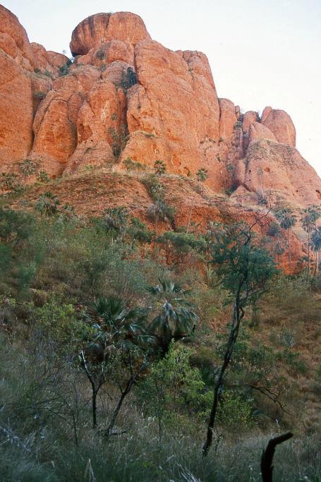
Where the sandstone contains iron, the hues of yellow, red, and brown emerge, giving the gorge a breathtaking array of colours. The ecological diversity of the area is also extensive. The transition from the dry desert climate in the south to the humid monsoon climate in the north is a significant factor. For Aboriginal people, this fascinating area holds great cultural significance, being a sacred place with numerous burial sites. Since 2003, Purnululu has been listed as a World Heritage Site.
Gradually, the bare brown walls of the Bungle Bungle Range emerge in the distance. For now, there is nothing that distinguishes them from the many other mountain ranges we have encountered. The surroundings have gradually transformed into grassland with spinifex, scattered with occasional trees. John warns us about seemingly innocent white flowers along the road – they are highly toxic. If a particle of these flowers enters your eye, it can lead to blindness.
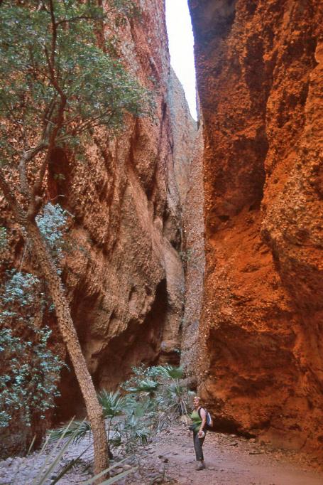
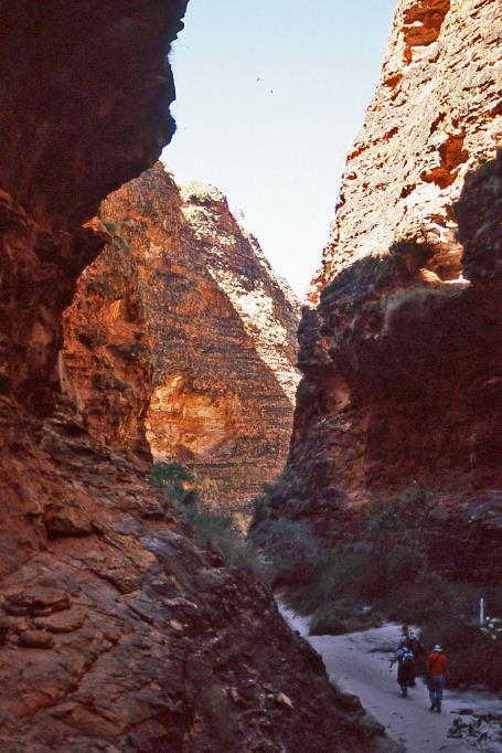
Echidna Chasm |
|
|
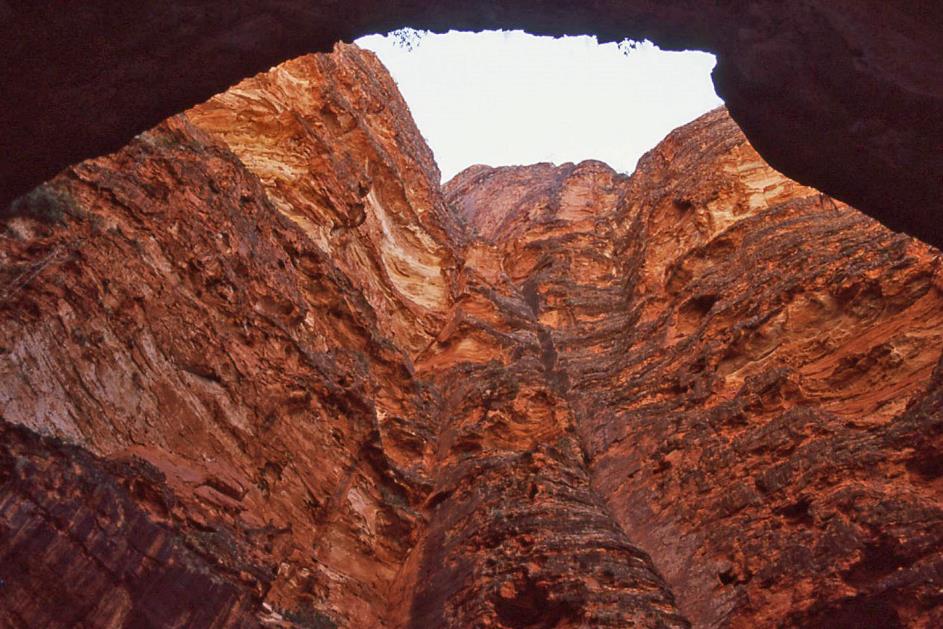
Eventually, we reach Echidna Chasm, a long narrow gorge in the northern part of the Bungle Bungle Range. We walk into the gorge through a dry riverbed filled with stones. The rock walls rise two hundred meters high on both sides. They are primarily composed of compacted rock blocks and sandstone, which is a rather alarming realization because it makes them highly susceptible to crumbling and erosion. Where the sandstone contains iron, the hues of yellow, red, and brown emerge, giving the gorge a breathtaking array of colours. Despite the narrowness of the gorge, many Livistona palms manage to thrive.
It's fascinating how this bird has found an artistic solution to its problem
Bowerbird nest |
|
|
For a moment, the courtship site of a bowerbird catches our attention. Normally, one would expect a colourful collection of, let's say, green or blue lure stones. However, this male has created a highly unique collection. He has paved the entrance to his bower with a well-balanced mix of white and blue-grey pebbles. Necessity is the mother of invention, he must have thought, as colourful objects are not easily found in this desert-like environment. It's fascinating how this bird has found an artistic solution to its problem.
As we penetrate deeper into the gorge, the walls seem to gradually close above our heads. Eventually, they obstruct our view of the blue sky. The gorge has become so narrow that we can touch both walls simultaneously. In ancient times, large rocks must have tumbled down the gorge. They are now blocked high above our heads. At least, that's what we hope. A few final climbs over ladders and rocks bring us to the endpoint, where we are surrounded on three sides by steep cliffs.
We leave the gorge behind and climb up to the Osmand Range Lookout. At our feet, a valley full of spinifex stretches out, with the inconspicuous hills of Osmand Range on the other side.
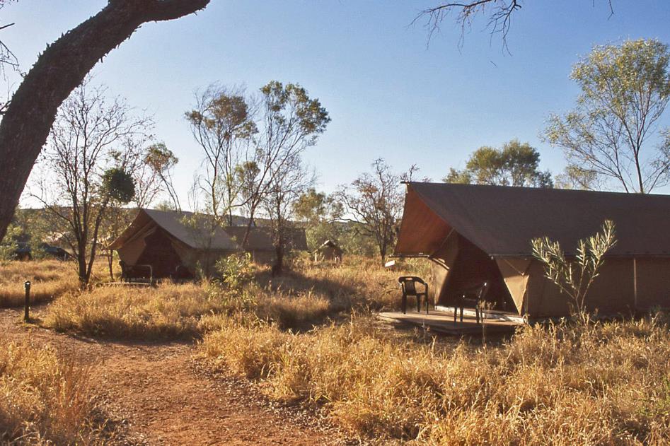
Tent camp at Bellburn Creek
It's five o'clock when we reach the lodge. Comfortable tents, complete with ensuites featuring a shower, sink, and toilet, await us on the banks of the dried-up Bellburn Creek.
It doesn't take long before we notice the Dutch accent of one of the staff members. Her name is Mieke, and indeed, she hails from the Netherlands. She met an Australian in Nepal, and they are now married, living in Tasmania for the past two years. Currently, they are both working for the tour operator here.
Night gradually takes over from the day. It's not unlikely that it will be colder here than the previous nights since we are approximately 250 meters above sea level.
Saturday, August 9 | Purnululu
A three dog night, that’s what our Australian travel companions call a night like this. The term originates from sheepherders who had to sleep outside. When a cold night was anticipated, they let the dog sleep on their legs to generate warmth. Sometimes, the nights were so cold that even three dogs weren't enough to provide sufficient warmth.
A three dog night, that’s what our Australian travel companions call a night like this
Despite the temperature dropping to 3 °C (37 °F) during the night, it doesn't deter the birds from starting their familiar serenades around half-past five. But things change quickly here. Two hours later, at breakfast, the sun has completely pushed back the cold. A warm, sunny day is on the horizon.
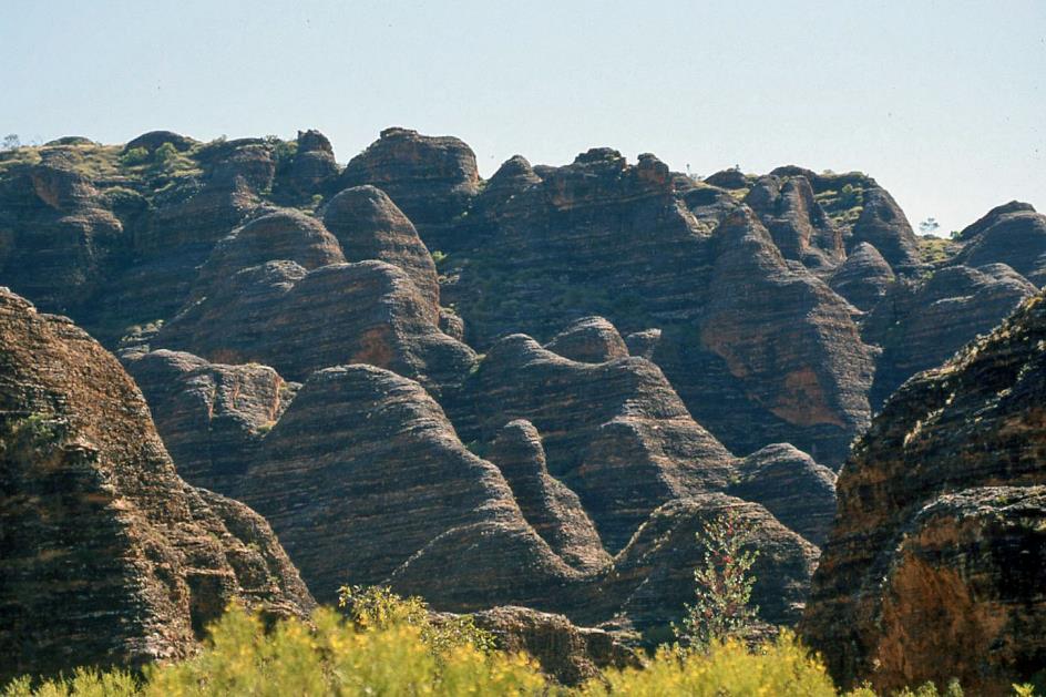
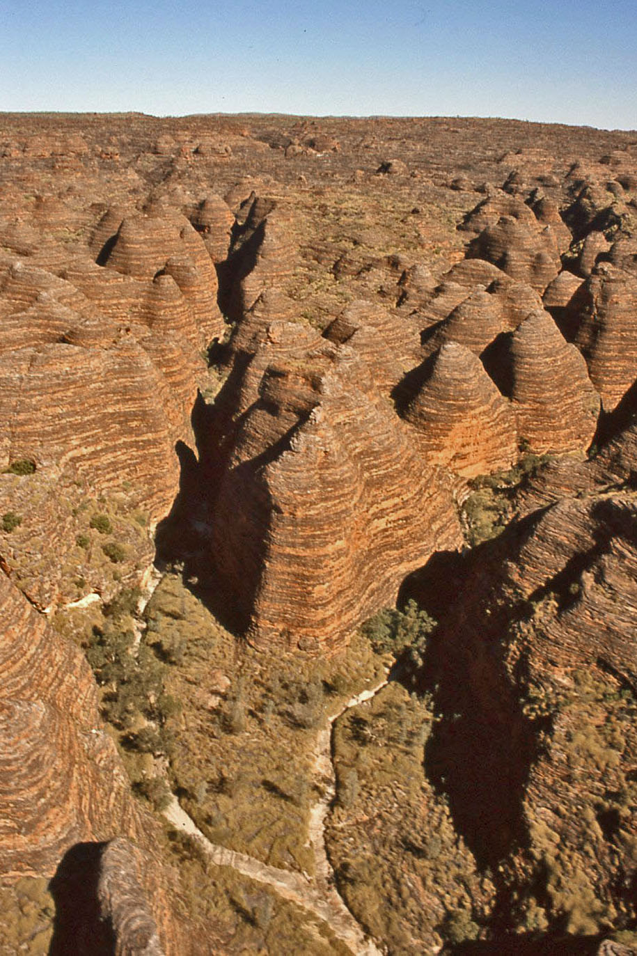
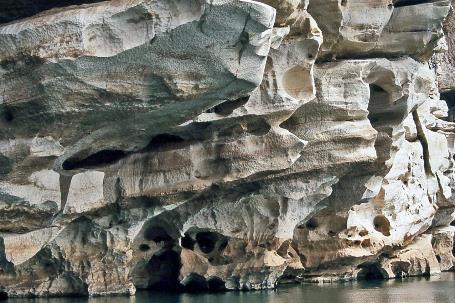
Towers of sandstone in the shape of gigantic beehives, with mysterious horizontal brown-red and light-grey bands
This is not without danger. Signs along the road have warned us before. The risk of fire is considered extremely high here. To the east of our camp, they have even pre-emptively burned the bush. Only trees remain standing; the dry grass lies charred. It's understandable that our tour operator wants to protect their investments in the camp infrastructure.
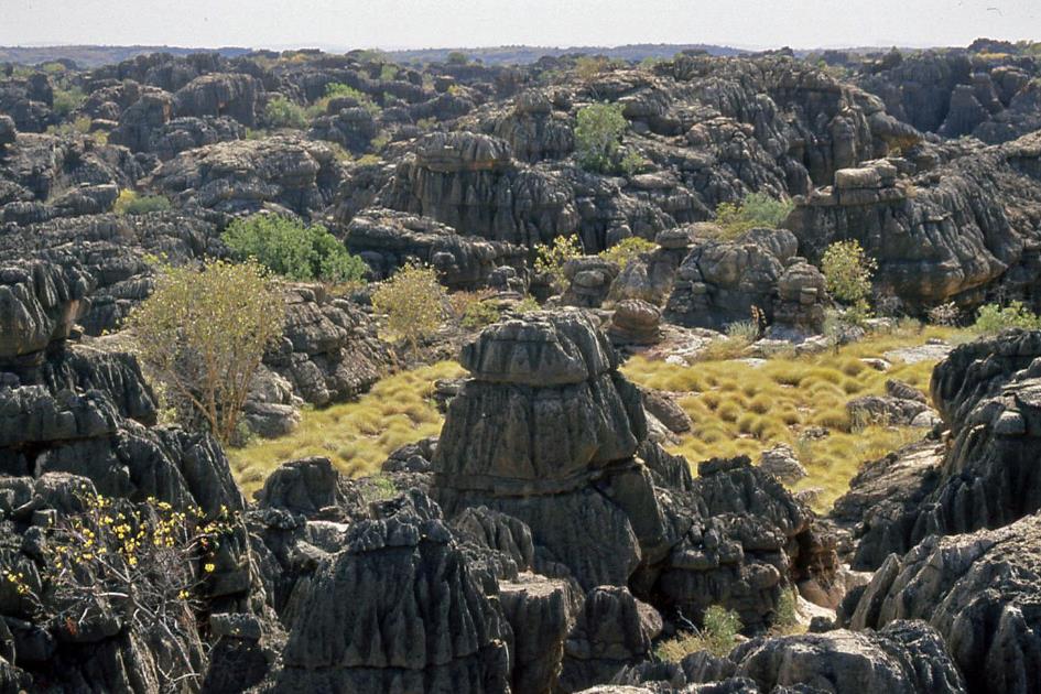
Today, Piccaninny Creek is our first destination. But first, we pause at Elephant Rock, a collection of rock formations where, with some imagination and from the right spot, you can recognize an elephant with a trunk. Mount Buchanan rises to the right in the distance, somewhat isolated from the rest, but still one of the higher rock masses in the park at 417 meters. However, all our attention is drawn to the left. There, in the distance, we finally see them – our first beehive formations – towers of sandstone in the shape of gigantic beehives, with mysterious horizontal brown-red and light-grey bands. It's as if the local architect has a fascination for building in layers of bacon.
It must have been about 360 million years ago that these sandstone layers were deposited here. Only in the last 20 million years have the spectacular domes, cracks, and gorges emerged from this, entirely attributed to the relentless erosion by water, weather, and wind.
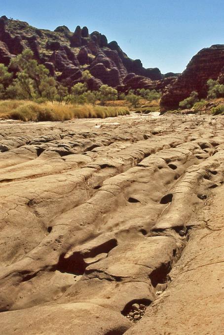
Piccaninny Creek
As for the strange horizontal bands, we have to point to cyanobacteria. Where the sandstone can accumulate enough moisture, these microorganisms thrive. That's where the grey bands originate. After rainfall, they even become shiny black. In places where the sandstone contains too much iron oxide, it dries out too quickly, preventing cyanobacteria from gaining a foothold. These layers retain their typical brown-red colour.
As for the strange horizontal bands, we have to point to cyanobacteria
Piccaninny Creek |
|
|
Climbing in John's footsteps, we ascend the highly eroded riverbed of Piccaninny Creek. During the rainy season, this is the primary drainage channel of Bungle Bungle Range, but now the bed is dry. Deep grooves and irregular bumps and lumps make it a treacherous path, giving an idea of the force with which water can rampage through here during the wet season. From Piccaninny Lookout, we get a good view of the surroundings.
In nature, all objects are not just randomly placed but are situated with a specific purpose at a specific location. This is the perspective of the Aboriginals, as conveyed through the Dreamtime stories. If you take something from nature, like a stone, you take away a spirit. Therefore, it's a good reason to avoid disturbing natural areas like this, especially considering the ecological perspective leads to the same conclusion.
To Piccaninny Lookout |
|
|
John puts his words into action, picking up a piece of sandstone. Effortlessly, he crumbles it with his bare hands. This fragility is indeed characteristic of the massive sandstone formations we see around us. We already suspected this during our journey through Echidna Chasm last night.
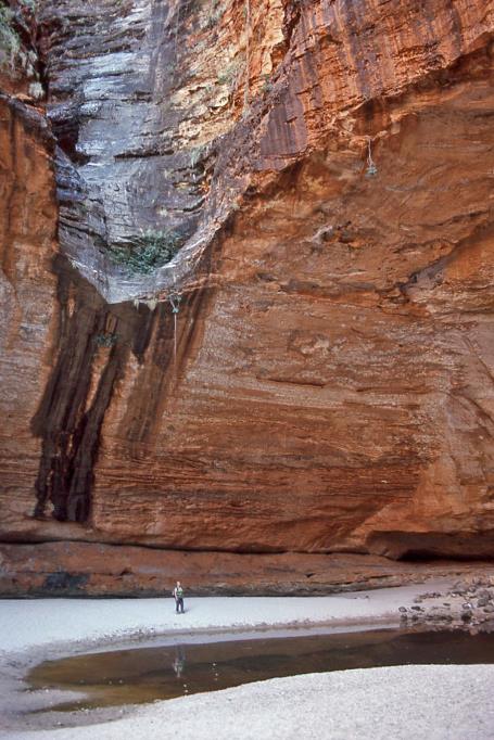
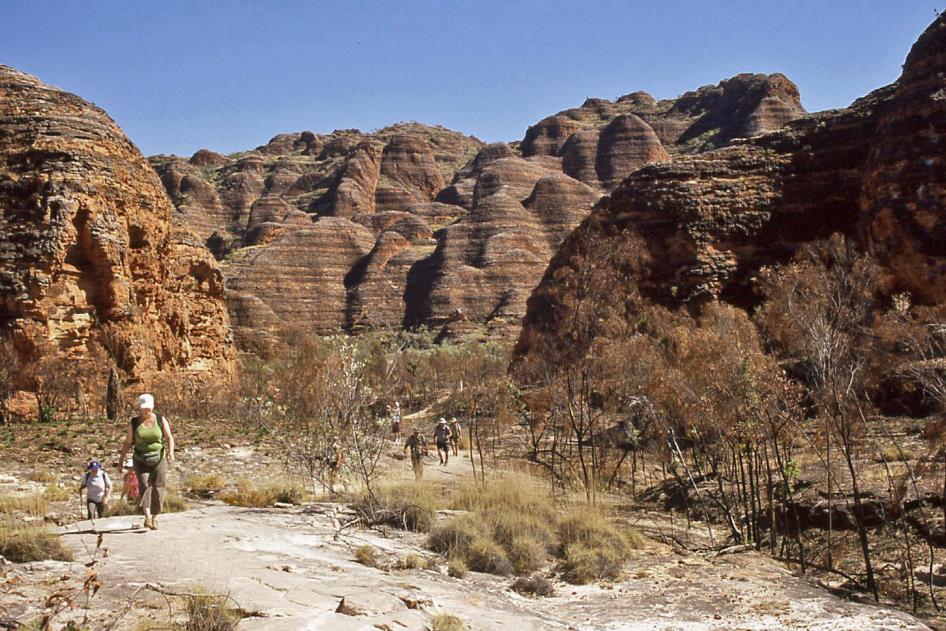
Cathedral Gorge is our next destination. Like Echidna Chasm, it is a two-hundred-meter-deep gorge in Bungle Bungle Range, but considerably longer. We can follow the riverbed between the sandstone formations for a whopping one and a half kilometres. Along the way, John points out some rock paintings of boomerangs on the cliff.
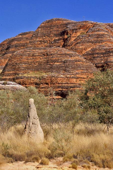
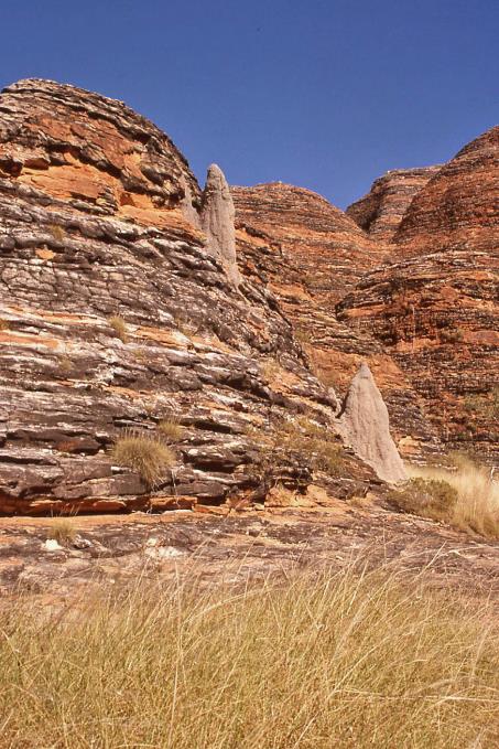
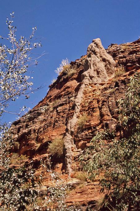
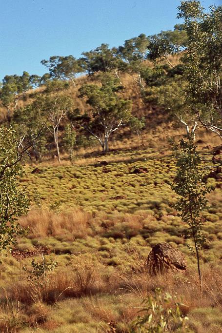
Termite mounds are a familiar sight in this landscape, even high up on the slopes. These social insects thrive best at a temperature of 24 °C (75 °F). They build their mounds with sand grains glued together by their excrements. Their food is spinifex grass, and they are the only creatures on this planet capable of digesting it.
Unfortunately, spinifex grass grows at the bottom of the valley, as it requires water. Termites, on the other hand, build their fortresses high on the slopes to avoid that water. How then do the termites get their spinifex? No termite would ever think of scurrying back and forth in the full sun, in midday temperatures that can reach 50 °C (122 °F), to gather spinifex and store it in the pantry.
Termite mounds |
|
|
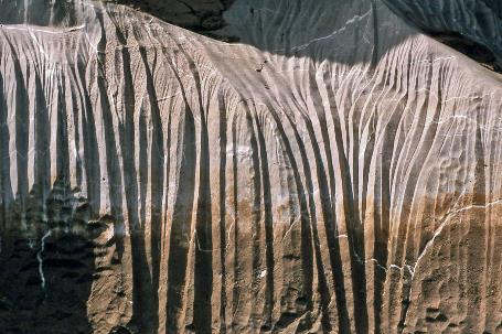
Through dozens of tiny tunnels in a thick tube, termites retrieve the vital spinifex grass from below
Termite mounds with tunnel system |
|
|
Apparently, some termites hold engineering degrees because they've devised the perfect solution to their problem. At each higher termite mound, we see a reasonably thick tube leading down the slope. If you were to cut through such a tube, John explains, you would uncover dozens of tiny tunnels through which the termites run up and down in relative coolness. The cross-section of such a tube indeed resembles a sieve.
Cathedral Gorge is narrowing down now, ultimately opening up into a gigantic cylindrical space, about 25 m high and 80 m in diameter. Several broad grooves in the rock wall and a small lake in the soft sand bear witness to the annual waterfall that adds more splendour to this immense space during the rainy season. The acoustics are unparalleled, as demonstrated when some people present spontaneously start singing the evergreen Amazing Grace.
A small lake in the soft sand bears witness to the annual waterfall that adds more splendour to this immense space during the rainy season
Cathedral Gorge |
|
|
We stroll calmly along the immense beehive structures of Domes Walk. The tropical sun is scorching our heads. We take a moment to seek the shade of a gorge. A few dozen frogs, no larger than a two-euro coin, have turned a puddle of water into their habitat. It seems like an excellent setting for our picnic.
Purnululu National Park
Horseshoe Valley
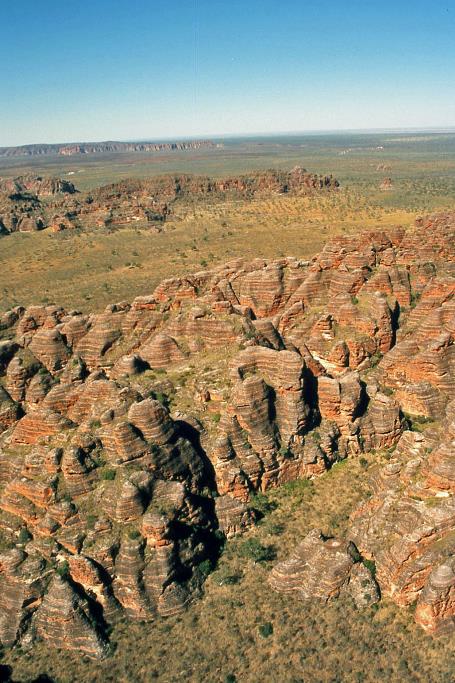
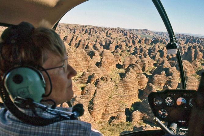
Shortly after one o'clock, we are heading to Bellburn Airstrip, an unpaved runway for light aircraft. However, it is also home to a handful of Robinson R44 helicopters that offer aerial tours over Purnululu. And that's precisely what we're going to do – explore this vast park from the air by helicopter.
It will be a flight over a landscape like no other. There seems to be no end to the spectacular sandstone formations
In a few weeks, on September 14th [2008] to be precise, one of these helicopters will crash above Piccaninny Creek. The pilot will lose his life, along with his passengers, three young women from Kununurra, barely 19 to 20 years old. The media will not publish the name of one of the three due to cultural reasons. This indicates that she belonged to the Aboriginals, as in their culture, mentioning names or showing photos of the deceased is taboo.
But we don't know all of this yet. So, we board one of the helicopters without concern. It turns into a flight over a landscape like no other. There seems to be no end to the spectacular sandstone formations. As far as the eye can see, the characteristic beehive domes rise in all their diversity, with varied shapes and sizes, yet always with that common denominator – elegant, rounded forms and colourful layers of red-brown and grey.
For the Kija, the local Aboriginals, Horseshoe Valley is one of the holiest places in the area, explains pilot Joe. There are no roads in this valley, but there are many graves. Respectfully, he flies in a wide arc around it. Even flying over the valley would be considered a desecration.
|
|
|
In the green hills, you can already recognize the beginnings of what will likely become beehives in the distant future
|
|
|
Below us now stretches a sandstone plateau of green hills, covered with grass and scattered trees. Here, erosion has not yet taken such a toll. However, you can already recognize in these hills the beginnings of what will likely become beehive-like formations in the distant future. For thousands of years, rainwater has found its way to the edge of the plateau from here. This has created a herringbone pattern of shallow valleys along which water rushes down in small streams during the rainy season. Closer to the edge, these modest valleys grow into significant gorges where erosion has free rein. Wind, sun, and water then create those fascinating forms. Cyanobacteria do the rest.
|
|
|
Joe points out Piccaninny Circular Structure, a circular elevation that seems to be completely embedded in the plateau. With its diameter of about seven kilometres, it somewhat resembles a massive caldera. Geologists suspect that it is a relic of a meteorite impact more than 300 million years ago.
In the evening, John pulls a surprise out of his hat. A stone's throw from the camp, he sets up a table and chairs, treating us to a beautiful sunset. This is not particularly challenging given the cloudless skies we have been enjoying for days. To add extra lustre to the special evening, he doesn't come up with the usual coffee and tea, but with cheese snacks, red and white wine, and – believe it or not – a CD of André Rieu.
In the evening, John pulls a surprise out of his hat
The location is excellently chosen. Facing east, we enjoy the delightful spectacle. It's not the setting sun that steals the show here, but the subtle play of colours from the rosy glow slowly gliding over the mountain range, setting the beehive formations on fire.
Sunday, August 10 | Purnululu – Fitzroy Crossing
For the first time, we manage to beat the birds at their own game. While they are still rubbing their eyes and stretching their wings, our camp is buzzing well before half-past five. With an almost five-hundred-kilometre journey ahead, it's necessary.
A high, thin layer of clouds settled over Purnululu last night, but that couldn't prevent the night from being bitterly cold once again. Outside the tent, at least, because under our delightful woolen blankets, the cold doesn't bother us at all. Fortunately, the temperature rises rapidly – it's already 5 °C (41 °F) during breakfast.
The abandoned cemetery reminds us of one of the great epic stories of the Australian outback
It takes us almost two and a half hours to navigate the bumpy terrain of Spring Creek Track and reach the paved Great Northern Highway. But once we're there, things speed up considerably. While the clouds gradually unravel high above our heads, we effortlessly cover the kilometres that separate us from Halls Creek.
With its twelve hundred inhabitants, Halls Creek is the only significant settlement along this highway for about six hundred kilometres. The reason so many people settled in this remote place is quite specific, just like in Broome. Here, it's not pearl divers putting the town on the map; it's gold miners. In 1885, a man named Charlie Hall discovered gold here. More than fifteen thousand fortune seekers flocked to what is now called Old Halls Creek from far and wide. Gold was scarce, though, and living conditions were harsh. Three months later, everyone had disappeared.
We don't have time to visit Old Halls Creek. That's okay; there's little worth seeing, not counting the abandoned cemetery. However, it reminds us of one of the great epic stories of the Australian outback. It is the place where James Darcy is buried, a cattleman who had a serious fall from his horse. It took hours for his mates to find him. Then it was another half-day of suffering on the wooden cart that brought him over these terrible roads to Halls Creek. Not that there was a hospital available, or even a doctor. There was a postmaster, though, and he had limited medical knowledge. And a telegraph machine. In desperation, he contacted his mentor, Dr. Holland, in distant Perth. A ruptured bladder, urgent surgery necessary – that was the diagnosis via telegraph. The postmaster went to work with what he had – morphine, a pocket knife, and a razor. Yet, the operation seemed to succeed.
The tragic story gave a decisive boost to the realization of a concept that had been lingering for a while – the Royal Flying Doctor Service
Complications arose, however. Dr. Holland didn't hesitate and promptly boarded a cattle transport from Perth to Derby. From there, he continued with a Ford Model T, then reluctantly with cart and horse, eventually on foot. He needed two weeks for his quest of 3,700 km. Unfortunately, Jim Darcy had passed away a day before his arrival. Nevertheless, the fate of the unfortunate cattleman in the midst of wartime – it was 1917 – made headlines in all national newspapers. The tragic story gave a decisive boost to the realization of a concept that had been lingering for a while – the Royal Flying Doctor Service.
|
|
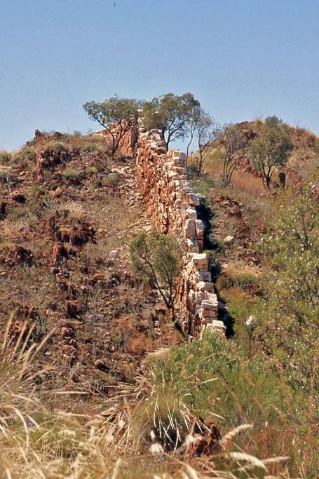
Halls Creek – ‘China wall’ |
These days, tourism is a significant asset for Halls Creek. The opportunity to showcase a unique natural phenomenon has not been missed by the small town. Specifically, it involves a vein of white quartz that formed in the soft rock here. Over time, the soft rock has completely eroded away, leaving only the hard quartz rock. The result, up to six meters high in some places, resembles a wall that seems as if it were built by human hands in the midst of the bush. They call it China Wall here. That might sound a bit exaggerated, but the comparison is not far-fetched. As the white-brown structure ripples for kilometres over the hills, it does evoke a bit of its illustrious Chinese counterpart, taking all proportions into account.
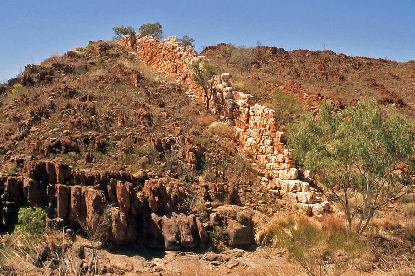
As the white-brown structure ripples for kilometres over the hills, it does evoke a bit of its illustrious Chinese counterpart, taking all proportions into account
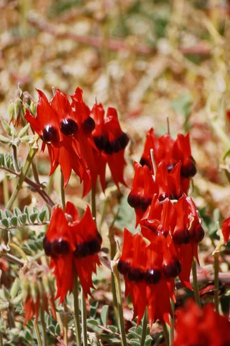
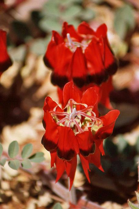
Even though it occurs throughout Australia, we have never seen it before. And here it is, right in front of us, blooming – one of the most famous wild plants on the continent, the renowned Swainsona formosa, commonly known as Sturt's desert pea. With its blood-red petals, it is a striking sight, further accentuated by the shiny black boss in the centre of each leaf.
Sturt's desert pea |
|
|
True to its name, you will only find this endemic desert plant in the dry regions of Australia. It is excellently adapted to the harsh desert life. Its seeds retain their viability for many years, thanks to the thick shell that shields them from the arid environment. When the tropical rains finally arrive, they will trigger the germination of the seeds.
A bit beyond Halls Creek, we pass by the turnoff to the Canning Stock Route. Few routes in the outback evoke more imagination than this legendary 1,850 km trail across Western Australia, from Wiluna in the south to Halls Creek in the north.
It's not a straightforward route as it traverses unforgiving deserts like the Great Sandy Desert and Gibson Desert. The seemingly absurd idea for such a route emerged when farmers in the early 20th century sought a new passage for their livestock to the ports on the west coast. They were prohibited from crossing through the Kimberley region due to tick fever affecting their animals. An alternative route through the desert seemed inevitable. The reasoning was that ticks would die off in the desert, a hypothesis that turned out to be correct.
Not only did they need an alternative route, but they also had to prepare it for livestock transports. Alfred Canning was the official assigned to accomplish this task. In 1906, he explored the route, and in 1907, he established the necessary provisions. Aboriginals assisted him in locating 51 water sources and developing drinking facilities for herds. To this day, these numbered water sources on maps remain the only landmarks along this mythical route.
It wasn't until 1911 that the first large herd was driven along the route. Unfortunately, it ended in disaster, as three drovers accompanying the herd were killed by Aboriginals near well 37. The Second World War saw a temporary revival of interest in the route. Livestock from the northern regions could be brought here out of the reach of the Japanese, or so they thought. However, before all water sources were restored, the war came to an end.
Today, it's not cattle you'll encounter along this route but 4WD enthusiasts
Today, it's not cattle you'll encounter along this route but 4WD enthusiasts. Around five hundred vehicles attempt the journey annually, usually in small convoys with thorough preparations. This includes stocking up on food supplies for two to three weeks and arranging for a fuel stash at the fuel drop point near well 23.
We stick to the comfortable Great Northern Highway and now make swift progress through a flat, tree-lined savanna. Mary Pool, a shaded spot among eucalyptus trees, is a typical 24-hour rest area. Visitors are allowed to stay for a day, including overnight stays in their motorhomes or caravans.
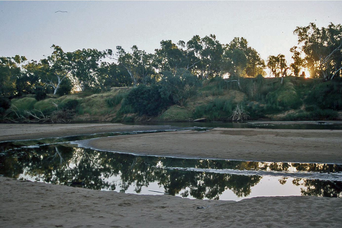
Fitzroy River
After four o'clock, we reach our spot for the night. No tent camp this time, but a proper lodge on the banks of the Fitzroy River. Today, the river is mostly dry, except for a few permanent waterholes. But every time the wet season approaches, it undergoes a spectacular transformation. It then turns into a mighty river that can be up to fifteen kilometres wide. Even the lodge, about a hundred meters from the dry riverbed, is not safe from the deluge. That's why they built the hotel on concrete stilts, about four meters above ground level. In the dry season, the space under the hotel serves as a cool parking area for the guests.
In the dry riverbed, a pair of brolgas forage for food. Further down, a monitor lizard is basking in the sun. But a black-necked stork is also present. Australians commonly call it jabiru, although strictly speaking, that term refers to a bird found exclusively in the New World. It is the only stork species you can encounter in Australia. Where many bird species are prevalent, you will rarely find a black-necked stork. It prefers marshlands, but dry riverbanks like this one also appeal to it.
It became an incredible odyssey, crossing Australia over a distance of 5,600 km
When brothers Charlie and Willie MacDonald settled near here at the end of the 19th century, they named their estate Fossil Downs because of the many well-preserved fossils found in the nearby Gogo Formation. Like the much more famous Duracks, the MacDonalds were cut from a very special timber. In March 1883, they set out with a herd of seven hundred cattle and sixty horses from Goulburn in faraway New South Wales. It became an incredible odyssey, crossing Australia over a distance of 5,600 km. For comparison, from Brussels to Moscow is 2,650 km – less than half the distance. When the MacDonalds arrived at Fossil Downs in June 1886, three hundred cows had survived the hellish journey. Nowhere in the world has a greater distance been covered with a herd.
Once again, we meet a European in the restaurant who seems to enjoy his time here. Ronan has only been working here for two weeks, and he is not yet very skilled in his job. He hopes to stay in Australia until December, after which he will return to his homeland, France.
Monday, August 11 | Fitzroy Crossing – Broome
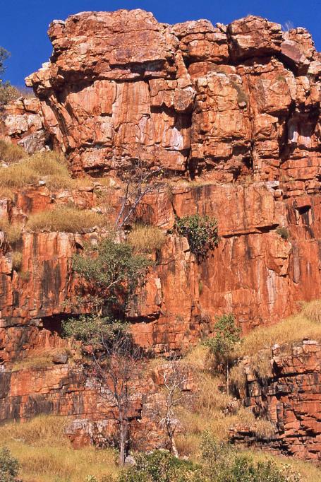
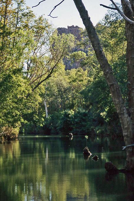
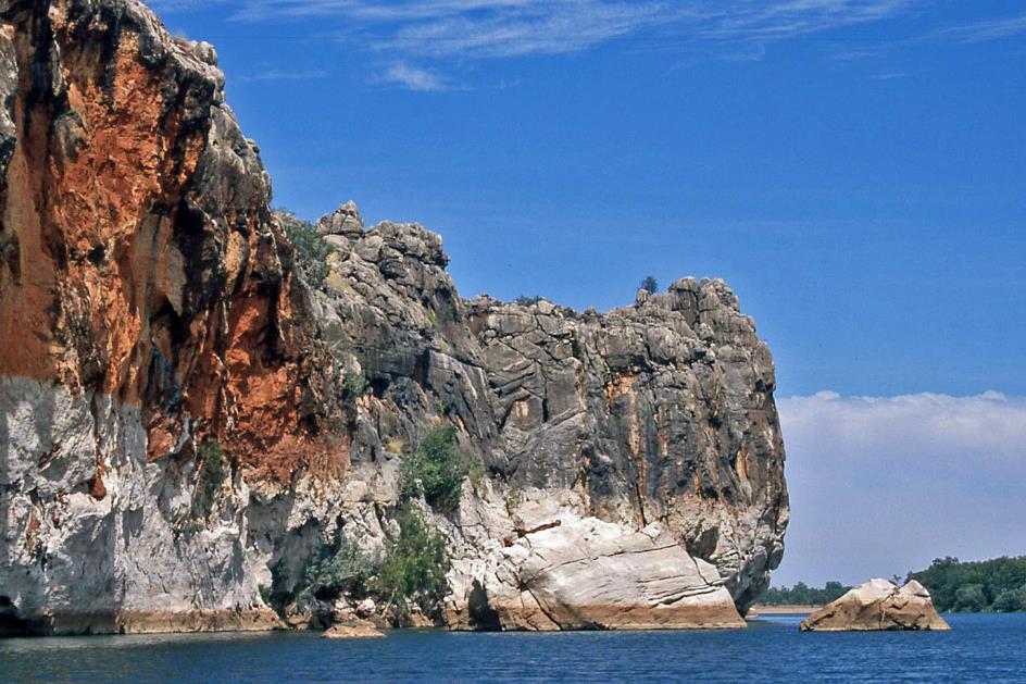
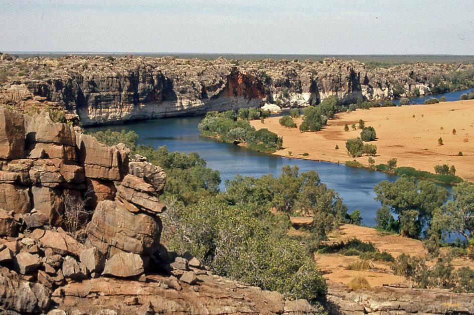
Our very last day in the Kimberley is here. Tonight, John will drop us off in Broome. But before that, we have a day trip to Geikie Gorge, an impressive gorge about twenty kilometres northeast of Fitzroy Crossing. Over time, it has been carved by the Fitzroy River into the Napier Range, the 350 million-year-old Devonian reef that we got to know on the first day.
The quarantine aims to prevent the spread of the noogoora burr, a plant that encases its seeds in a chestnut-like burr
Just before half-past eight, we board a boat for a river cruise. Bill will be our guide. This is a unique opportunity because, as the son of a white father and an Aboriginal mother, he is the perfect person to explain the connections and differences between the two cultures. We find ourselves in the natural habitat of the Bunuba. They have been here for thirty to forty thousand years. They call this gorge Danggu1) in their language.
Freshwater crocodiles |
|
Little pied cormorant and darter |
Freshwater crocodile
From here to its mouth at the sea, the river is over 220 km long. However, a quarantine area has been established on both banks of the river along the entire stretch. No one is allowed to enter. This measure aims to prevent the spread of the noogoora burr, a plant that encases its seeds in a chestnut-like burr. If this aggressive plant establishes itself among crops like cotton, corn, or soybeans, it can have significant consequences for yields. The weed competes for water and minerals crucial to these crops. If the prickly burrs attach to the wool of sheep, it can reduce their value. Even cattle can be affected, as the overgrowth might obstruct their access to water sources.
A giant white rock in the water dominates the surroundings. This is a highly sacred place, as an old man is said to have drowned here during the Dreamtime
Danggu Gorge (Geikie Gorge)
|
|
|
Instead of smooth, polished surfaces one might expect from erosion by river water, there are irregularly hollowed-out forms. It looks as if we are staring at giant pieces of popcorn
Freshwater crocodile
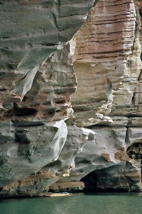
A bit further, East Wall rises perpendicularly from the river, reaching about thirty meters in height. Bill steers his boat towards the deep water at the base of this cliff. The place owes its name to this characteristic, as Danggu translates to the location where the water under the cave is deep. However, more striking are the bizarre shapes and colours of the rock wall. Up to where the water reaches during the rainy season – ten to fifteen meters above the current water level – the rock is snow-white. Higher up, it appears mainly brown and even orange. The white part at the bottom is intricately carved. Instead of smooth, polished surfaces one might expect from erosion by river water, there are irregularly hollowed-out forms. It looks as if we are staring at giant pieces of popcorn.
|
|
|
On a generous sandbank on the western side of a wide river bend, two brolgas stride majestically through the bushes. Just before nine, we disembark on the eastern Bunbura sandbank. After the rainy season, the river looks different every year. Same but different, mutters Bill as he surveys the surroundings.
Brolgas |
|
Danggu Gorge (Geikie Gorge) – West Wall |
If an Aboriginal family in the desert is to survive, they must meet their needs with what nature provides. Women search for water, make fire, and take care of the children, while men go hunting. Therefore, the key is to be able to read nature, Bill explains. For example, the presence of a cooba, an acacia-like plant, indicates that there is water underground. Spinifex grass, on the other hand, can be used to make needles because it is so sharp it can penetrate three to four layers of clothing.
The Bunbara sandbank, the wide river bend, and the distant West Wall lie at our feet
For us, it's essential to be cautious as we climb up a steep path over rocks through a gorge. However, our efforts are rewarded with a magnificent view at the top. The Bunbara sandbank, the wide river bend, and the distant West Wall lie at our feet. Across the plateau, there are remarkable eroded limestone formations that strongly resemble the tsingy of Madagascar or the Stone Forest of Shilin in China.
The remarkable eroded limestone formations strongly resemble the tsingy of Madagascar or the Stone Forest of Shilin in China
Continuing along West Wall, we proceed with our boat journey. The soothing rays of the morning sun reach the base of the intricately carved rock wall, making the rocks and niches ideal spots for sunbathing freshwater crocodiles. At Larrawun, we make a right turn.
In an Aboriginal community, it is strictly forbidden to talk to your in-laws. This makes arguing considerably more difficult. That, precisely, is the intention
The social and family life in an Aboriginal community is quite complex, with many rules and taboos, explains Bill as we leisurely return upstream to our starting point. For instance, it is strictly forbidden to talk to your in-laws. If you need to ask them something or convey a message, you're supposed to do it through an intermediary, even if you and your in-laws are in the same room. This makes arguing considerably more difficult. That, precisely, is the intention.
Danggu Gorge (Geikie Gorge) – East Wall
Marriage is not something you enter into casually with just anyone. This goes beyond the classical taboo on incest. As an Aboriginal, you belong to a specific kinship from birth, which anchors your relationship with others for a lifetime. The determination of which kinship you belong to follows the rules of tradition. The starting point is the mother's kinship, given that paternity is not always ascertainable with one hundred percent certainty.
Bill sketches two circles in the sand and divides them into four quadrants. Each quadrant represents a Bunuba kinship, which, in turn, breaks down into a male and a female kinship – sixteen kinships in total.
The order of the kinships in the circle is not arbitrary. You read them clockwise, starting from your quadrant. All women from the previous quadrant are considered your mothers – including your aunts. All women from the next quadrant are considered your daughters – including your nieces. Complex, but simple, Bill summarizes the situation.
All women from the previous quadrant are considered your mothers – including your aunts. Complex, but simple, Bill summarizes the situation
In fact, this system aims to prevent inbreeding in the relatively small Aboriginal communities in the bush. Marriage is only permitted with a partner from a specific other kinship. Yet, with its sixteen kinships, the concept of Bunuba bewilders us a bit.
Much simpler is the situation in the Pilbara, where they distinguish only four kinships. If a Karimarra woman marries a Panaka man, their child is a Pal.yarri. It will only be allowed to marry a Purungu. Conversely, if a Panaka woman marries a Karimarra man, their child is a Purungu, and it can only marry a Pal.yarri.
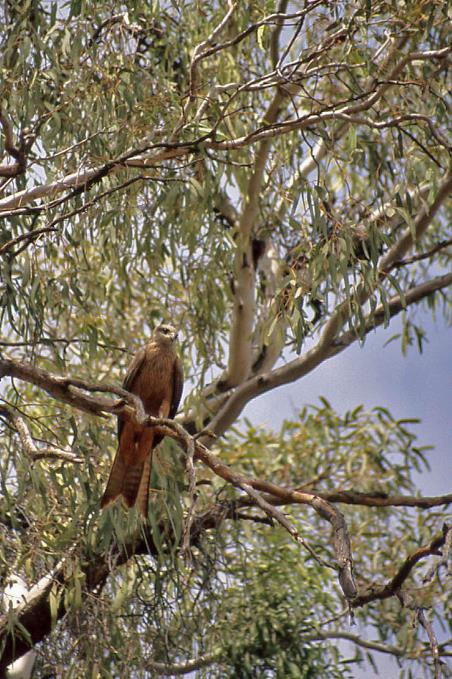
Black kite |
|
|
We allow the anthropological intricacies some time to settle. Meanwhile, the sun has risen high enough to let its warm glow reach the eastern bank of the gorge. Countless freshwater crocodiles bask in the sun, recharging their energy. On a bare tree stump, a little pied cormorant and a darter are also enjoying the same sun.
A gigantic white rock in the water dominates the surroundings. It is Danggu, the rock that gives this gorge its name. This is a highly sacred place, as during the Dreamtime, an old man drowned here. Before visitors from other tribes are allowed to enter this area, they must purify themselves by sprinkling river water over their heads. Subsequently, they must seek permission from the spirits in and around the rock to be present in this sacred space.
Well before noon, we've finished our early lunch and embark on the final leg of our journey. Short breaks, including a stop at the now familiar Willare Bridge Roadhouse, punctuate the drive.
With 166 km to go, we approach Willare Bridge, the 400-meter-long bridge over the Fitzroy River, where the wide road narrows to a single lane. Oncoming traffic cannot be crossed. Unclear crackling from the CB radio should have aroused suspicion, but no one pays it any attention. The mood is cheerful, the long drive is nearly over, and we've had a fantastic tour. Carefree, we drive onto the bridge.
Braking is not in the vocabulary of drivers of such road trains. With those trailers, it would inevitably result in a catastrophic pile-up
Then, on the other side, it turns out a road train is speeding onto the bridge. The massive vehicle is pulling three heavy trailers behind it. Apparently, a bend in the road concealed the vehicle from view. Braking is not in the vocabulary of drivers of such road trains. With those trailers, it would inevitably result in a catastrophic pile-up.
Lightning-fast, John throws his bush bus into reverse and races backward dozens of meters in no time. Just in time, we stand on the side. While the road train roars past us without slowing down, a voice on the CB radio, now clearly audible, yells, Told you I was coming, f*** idiot.
This doesn't prevent us from reaching Broome in one piece just before half-past five. Somewhat wistfully, we recall the warning they gave us three weeks ago in Perth when we announced our intention to travel to the Kimberley. Up there in the north, there's nothing, absolutely nothing, they told us. Meanwhile, we know better. Much better.
Jaak Palmans
© 2024 | Version 2024-01-23 15:00
1) Since 2016, the original Aboriginal name, Danggu Gorge, has been progressively introduced to replace Geikie Gorge.