No civilization has ever achieved that
Australia | Anno 2008
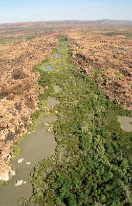
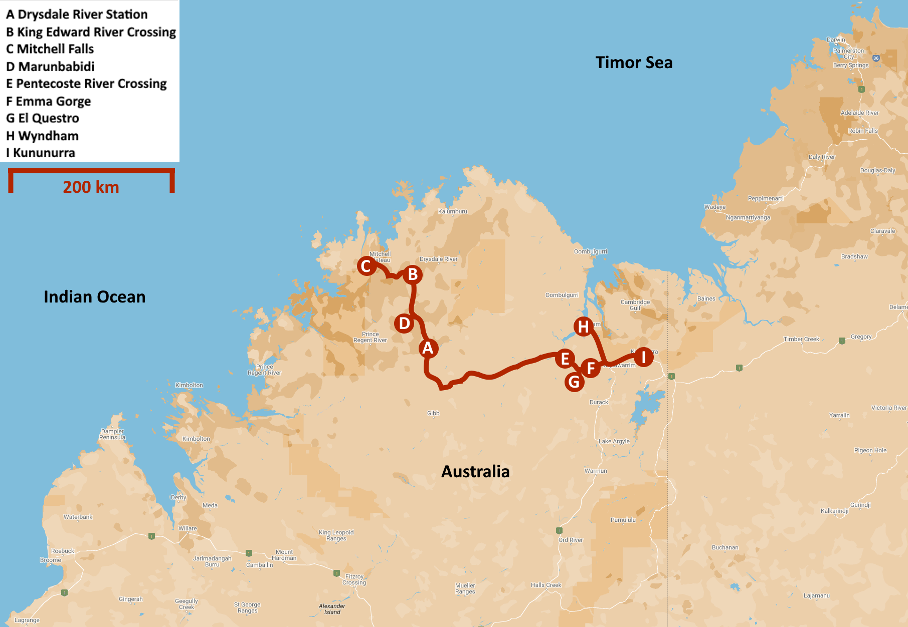
Saturday, August 2 | Drysdale River – Mitchell Falls
Sunday, August 3 | Mitchell Falls
Monday, August 4 | Mitchell Falls – Marunbabidi
Tuesday, August 5 | Marunbabidi – El Questro
Wednesday, Augustus 6 | El Questro – Kununurra
Saturday, August 2 | Drysdale River – Mitchell Falls
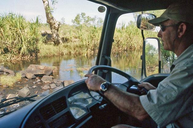
Even the birds here are so civilized that they wake us up only at six o'clock. Barely half an hour later, our driver and tour guide, John, is busy working on his bush bus. Bad roads ahead, we don't need a drawing for that. However, it seems like it will be a leisurely day, as John delays our departure until just before nine.
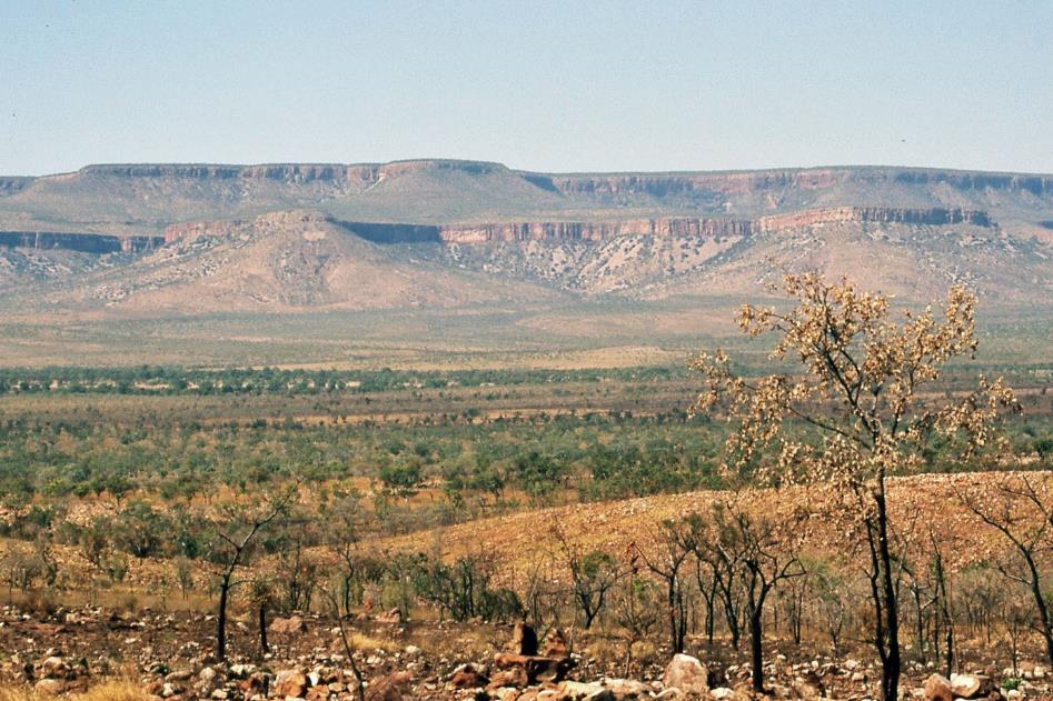
The Kimberley is said to be one of the very few areas in Australia where the original fauna is still intact
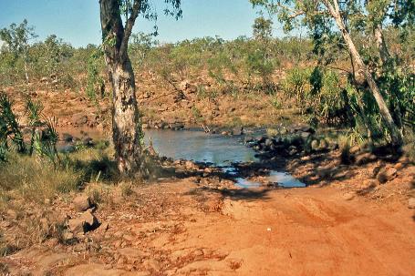
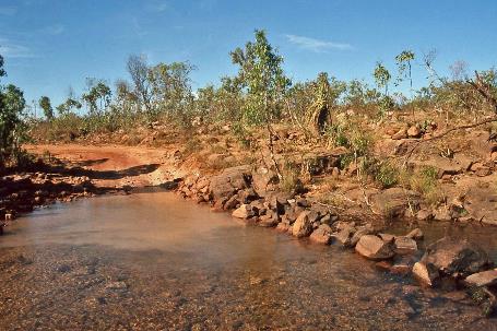
Just five minutes later, we cross Drysdale River. Mitchell River National Park, the area in the far north of the Kimberley, is said to be one of the very few areas in Australia where the original fauna is still intact. No species is said to have been eradicated since the arrival of the Europeans. This is likely more due to the remote location than to the ecological concern of those Europeans.
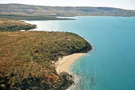
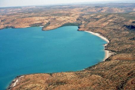
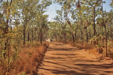
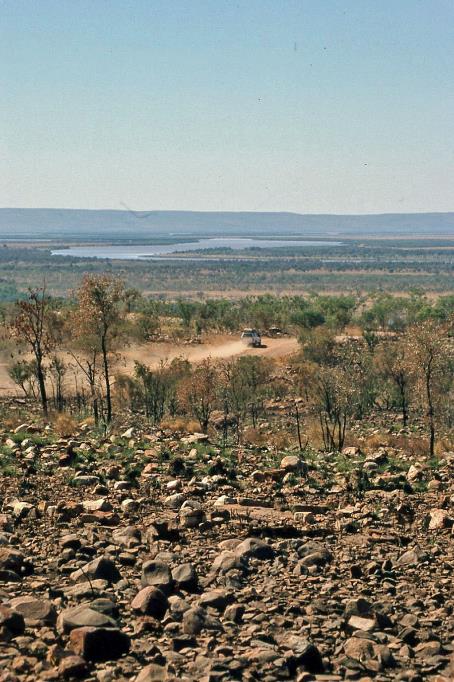
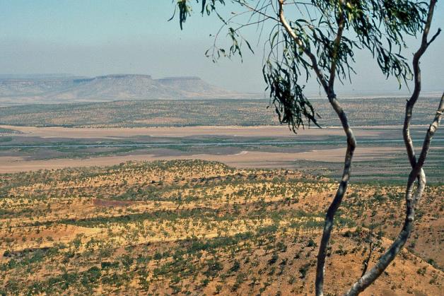
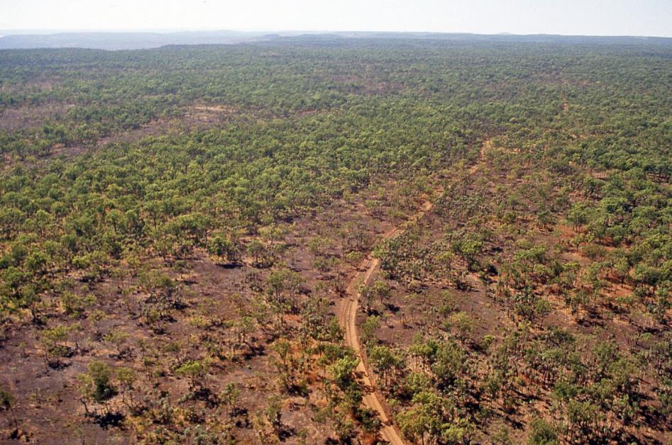
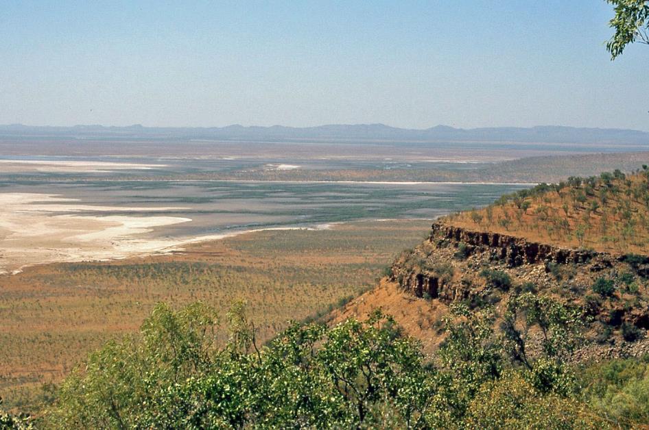
It's half past ten when the turnoff to Port Warrender Road appears, the formidable route to Mitchell Plateau, one of the highlights of our trip. As the crow flies, we are barely forty kilometres from the Timor Sea. The road is now much worse, John informs us from his driver's cabin. As if we hadn't noticed that ourselves. The only reason we're not all jumbled together is thanks to our seat belts. At the intersection, an Australian bustard watches us with undisguised amusement, as if he knows what awaits us.
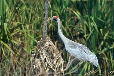
Brolga |
|
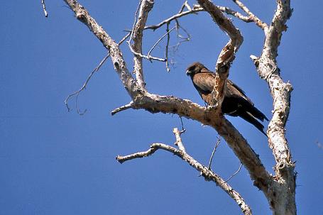
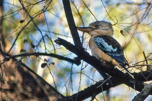
Black kite |
Where King Edward River intersects our path, our attention is drawn to a pair of graceful, silvery-grey birds with a striking red band on the back of their heads. They are brolgas, found throughout Australia, especially near rivers and wetlands. They can grow up to 1.6 meters and are known for their fascinating mating rituals.
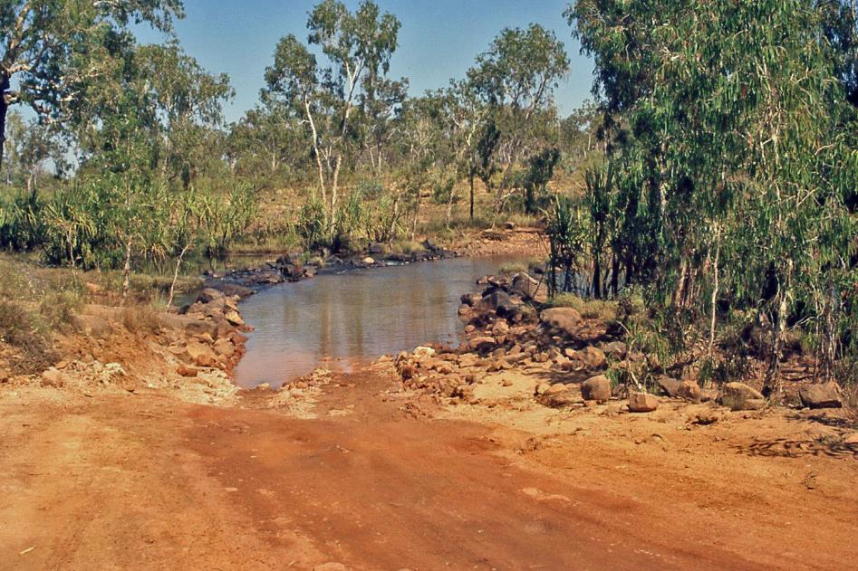
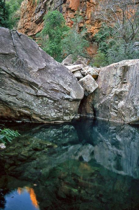
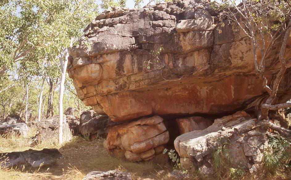
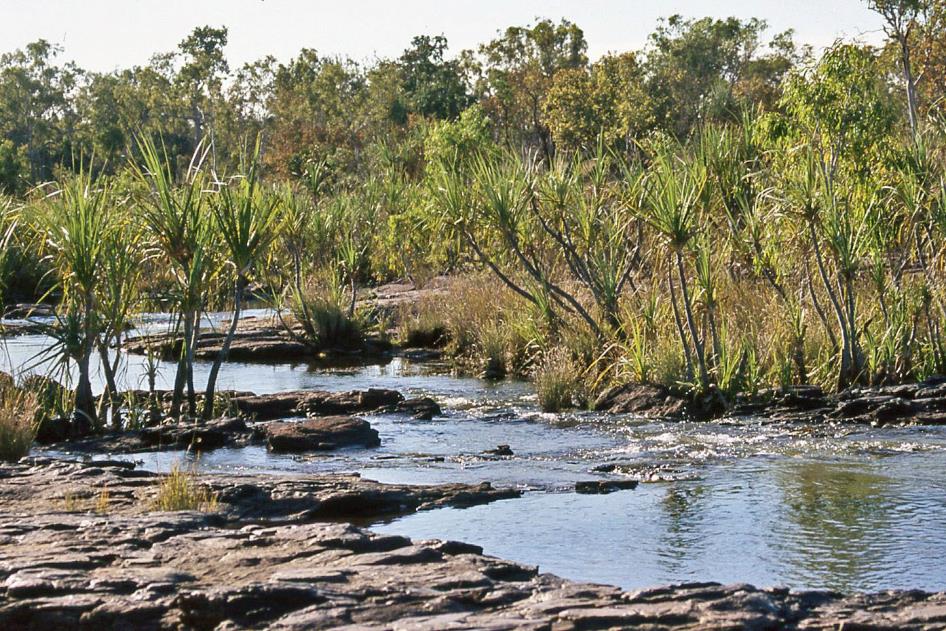
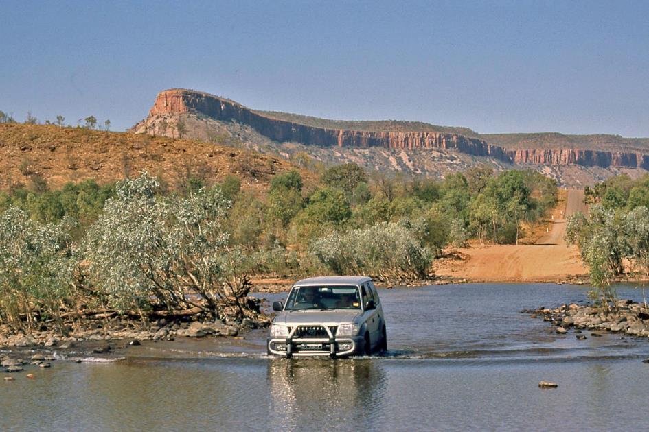
King Edward River Crossing
Of course, there are no bridges here. Our bush bus wobbles cautiously over the slippery stones through the water to the other side, where we settle on the campsite Munurru under the trees. We are not alone. A friendly couple of grey nomads relax in the shade next to their camper, which they have temporarily converted into a tent. They have connected their fridge to the battery of their 4WD, which, in turn, is charged with a portable set of solar panels.
The whites have learned the technique of controlled bushfires from the Aboriginals, who have been using it for thousands of years
Once again, the river invites us to swim. After all, we don't have to worry about freshwater crocodiles here. The silence is noticeable; few birds make themselves heard at this sultry noon. High above our heads, a smoky cloud passes by. They are probably pre-emptively burning a piece of bush in the west. It's a form of nature management to prevent bushfires from turning into huge infernos. The Europeans have learned this technique from the Aboriginals, who have been using it for thousands of years. The idea that Aboriginals don't look ahead, as Linda told us yesterday in Gibb River Station, does not seem to be confirmed here.
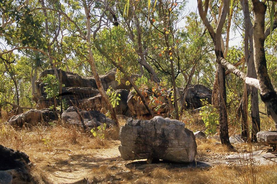
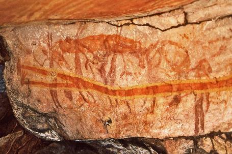
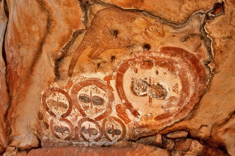
What initially appears to be a casual stroll without a specific goal quickly turns into a spectacular surprise
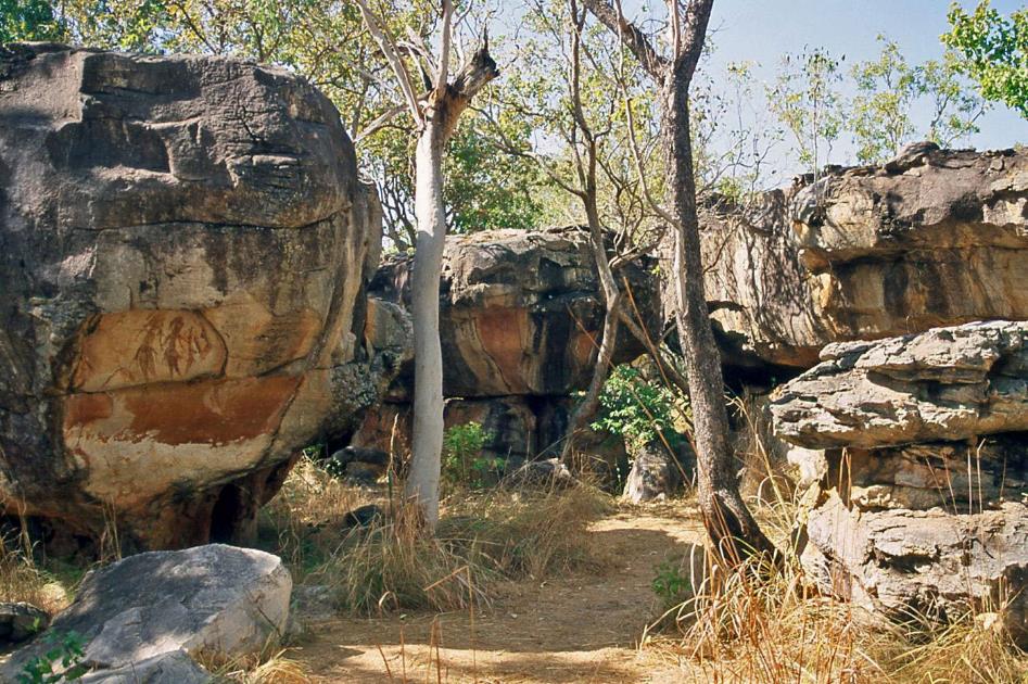
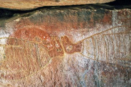
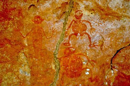
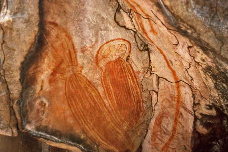
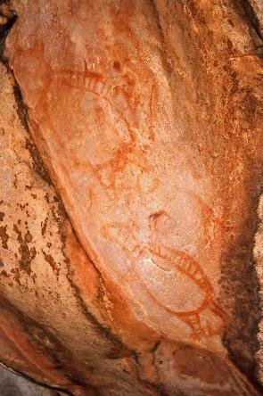
Gwion Gwion rock paintings (on the left)
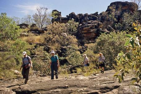
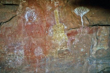
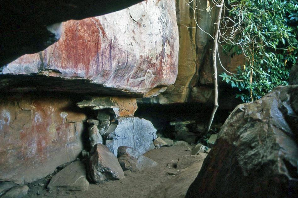
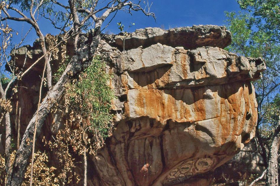
After lunch, we venture into the bush with John. What initially appears to be a casual stroll without a specific goal quickly turns into a spectacular surprise when rock formations emerge from the tall savannah grass. These rocks turn out to be the canvas for magnificent Aboriginal rock art.
The refined elegance and spontaneous vitality that have emanated from this rock wall for thousands of years leave us amazed
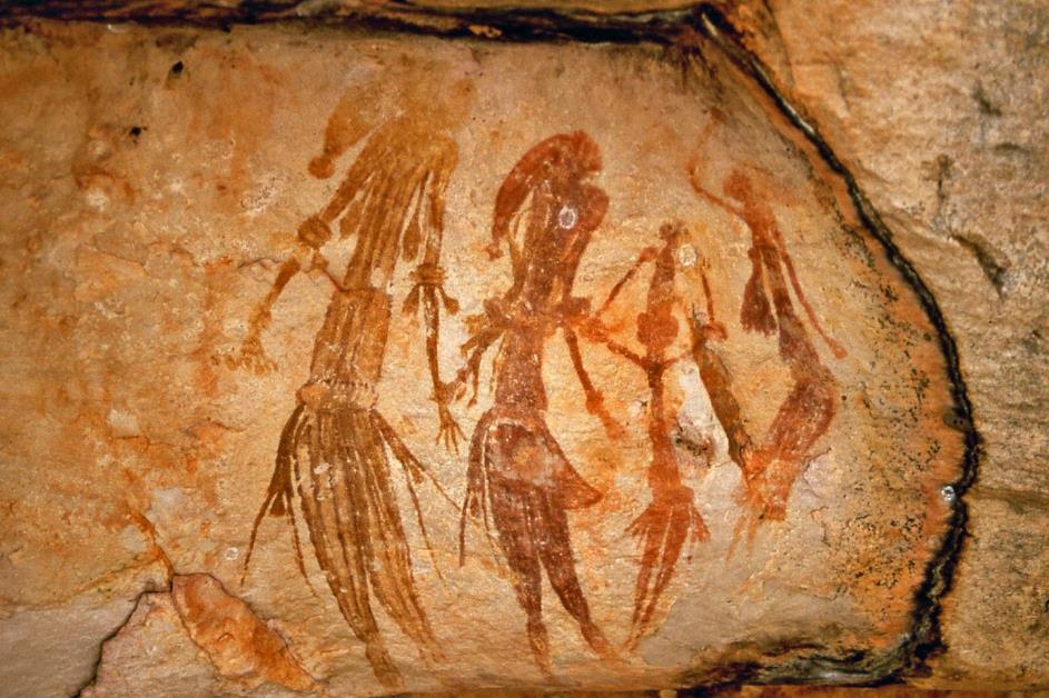
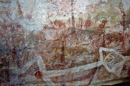
Four human figures in reddish-brown iron oxide immediately capture all attention. It seems as if these beings are dancing, so dynamic is the scene. You can distinguish their headdresses, clothing, and the jewellery around their arms. The refined elegance and spontaneous vitality that have emanated from this rock wall for thousands of years leave us amazed. Even in a contemporary interior, this medallion would be far from out of place.
Whites call this art form Bradshaw Art, named after the cattleman Joseph Bradshaw, who ‘discovered’ the first rock art in 1891. Aboriginals, on the other hand, prefer the name Gwion Gwion. Meanwhile, we know that thousands of such rock paintings exist in the Kimberley, forming one of the two major art traditions in this harsh and desolate region.
The age of these Gwion Gwion rock paintings is a subject of strong debate among experts. Our ability to make any meaningful statements about the age of these drawings is mainly thanks to mud wasps. They sometimes build their nests right on the paintings. Since mud often contains charcoal from bushfires, carbon dating tells us how old the nests are – approximately twelve thousand years. The rock paintings cannot be more recent. Most likely, the majority of these artworks are between 12,000 and 20,000 years old.
Aboriginals know the origin of these drawings. Long ago, they say, there lived Kujon, a black bird who painted on the rocks. To do this, he pecked at the stones until he bled. With that blood, he began to paint – not animals, but human figures that likely represent spirits.
Most likely, the majority of these artworks are between 12,000 and 20,000 years old
Lying brolgas |
|
Lying figure with a ceremonial mask |
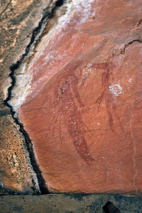
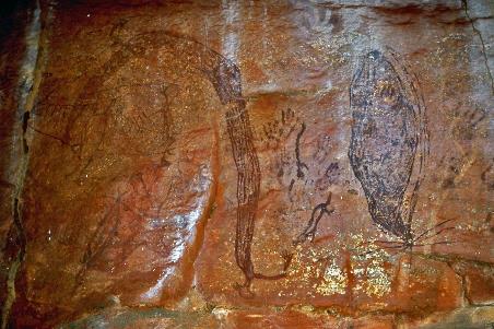
But there are other images in this open-air museum. On the wall of a tunnel between two rock blocks, we discover a beautiful pair of brolga crane birds, mainly executed in white and ochre. Another figure lying down is adorned with a peculiar ceremonial headdress.
Evil spirits |
|
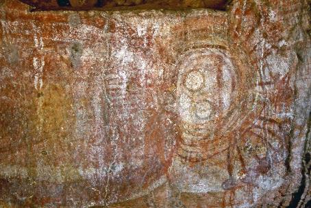
Wandjinas |
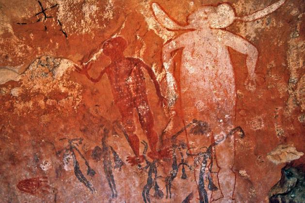
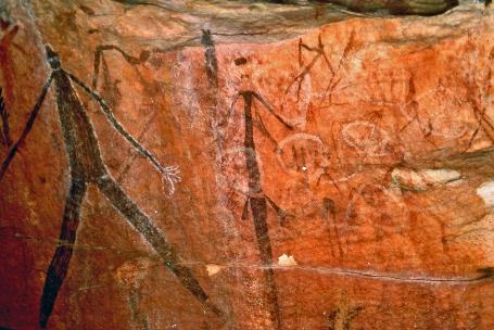
A trio of amusing-looking figures represent evil spirits, but for us, it is difficult to grasp that such clownish figures should instil fear in us. Perhaps they are not so malevolent after all, as they are the ones who have taught humanity everything.
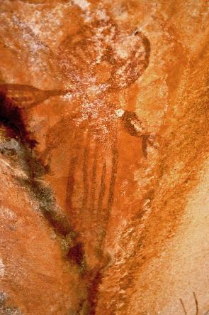
On either side of his head, he wears a strange long trunk – or are they the thick edges of a gigantic hat?
|
|
|
A highly peculiar figure, entirely executed in white, concludes the series. On either side of his head, he wears a strange long trunk – or are they the thick edges of a gigantic hat? The Swiss pseudoscientist von Däniken made grateful use of it at the time. According to him, such drawings proved that intelligent extra-terrestrial beings have visited Earth during prehistoric times.
Next to it, a small brown figure has taken its place, covered with dots, indicating a ceremonial scene. A bit lower, bluish-grey figures dance. This is also typical of Aboriginal rock art – often, the artist simply paints over the work of his predecessors.
Gwion Gwion rock paintings (on the right)
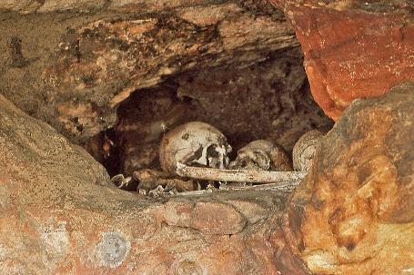
A trio of human skulls with accompanying bones lie exposed in a cavity in a rock wall. This is an Aboriginal burial site, says John. When someone passes away, they cover the body with a stack of stones. Once the tissue has completely decayed, they unearth the bones, collect them in a specially made wooden box, and carry it to all the places the deceased has ever been. In this way, everyone can bid a proper farewell. Only after that, the bodily remains are placed in their final location, such as here, in a cavity in the rock wall.
They carry the bones to all the places the deceased has ever been. In this way, everyone can bid a proper farewell
Aboriginal burial ground |
|
Small fan palms |
We continue our journey northward. All in all, the state of the road seems to be not too bad, at least according to John. Our judgment remains the same – this road is extremely poor. The explanation for John's optimism doesn't take long. There appears to be a grader at work, a bulldozer levelling the crushed gravel. The first time in four years, John grins.
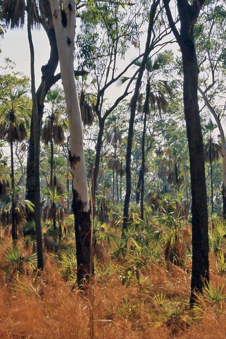
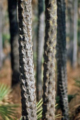
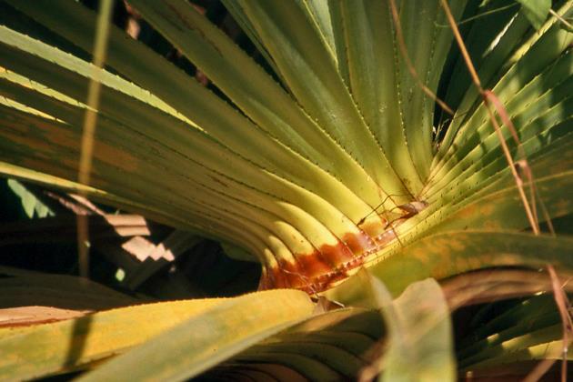
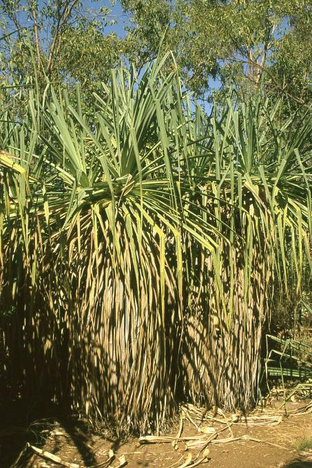
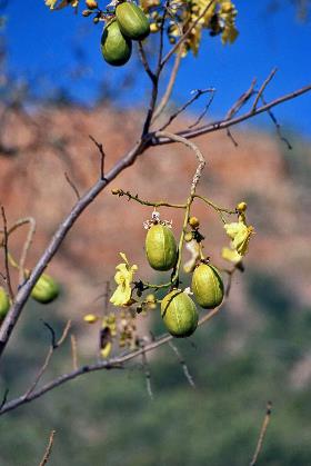
A short but fierce climb announces the edge of the Mitchell Plateau. The familiar bush vegetation now gives way to the Livistona Eastonii, a slender fan palm that occurs nowhere else but on this plateau. This tdunguna, as the local Wunambal call it, can grow up to eighteen meters high. Some specimens are estimated to be over three hundred years old. For Aboriginals, this Livistona is sacred because, in times of severe drought, it plays a vital role. It becomes virtually the only source of carbohydrates in the inhospitable Kimberley. It's not surprising that it is a recurring motif in rock paintings that are thousands of years old.
Port Warrender Road to Mitchell Falls
In the upper layer of the Mitchell Plateau, quite a bit of bauxite is found, and the government has even issued a concession for commercial exploitation. Fortunately, no action is being taken at the moment because there is little demand for bauxite. Moreover, another problem has arisen. The concession stipulates that after mining, the natural vegetation must be restored. However, pilot projects have shown that you can't get a Livistona to grow in disturbed soil.
For Aboriginals, this Livistona is sacred because, in times of severe drought, it plays a vital role
|
|
|
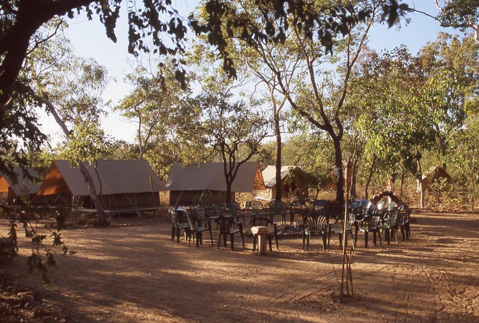
After four, we reach Ungolan Wilderness Camp, a permanent tent camp on the banks of Camp Creek, a stone's throw from the Aboriginal community of Kandiwal. The place looks more like a construction site than a tent camp. Apparently, each tent is currently undergoing an expansion they call an ensuite – a comfortable annex with a shower and toilet. This is excellent news for future visitors, but a bit less so for us. The whole camp is in disarray; a bobcat is busy, utility lines lie in open trenches, and some tents are not even available when we arrive.
Trunk of the tdunguna |
|
|
However, we don't let it get to us. Michelle navigates us carefully between pits and holes to explain the ins and outs of her camp. Appropriately, she calls the waterhole of Camp Creek the pride of the camp. It's a mini-oasis they've even named Blue Lagoon. The call of the crystal-clear water is irresistible.
This time, our tent is named Wren, a reference to the Australasian wren, a songbird found only in Australia and New Guinea. These wrens are peculiar birds; they are socially monogamous yet sexually promiscuous. They form lifelong pairs but mate with any member of their kind willing to participate. Together, the pair raises the offspring, regardless of who the biological parents are.
Just after six, we gather around the campfire. A serenade of frogs and crickets accompanies us into the night.
Sunday, August 3 | Mitchell Falls
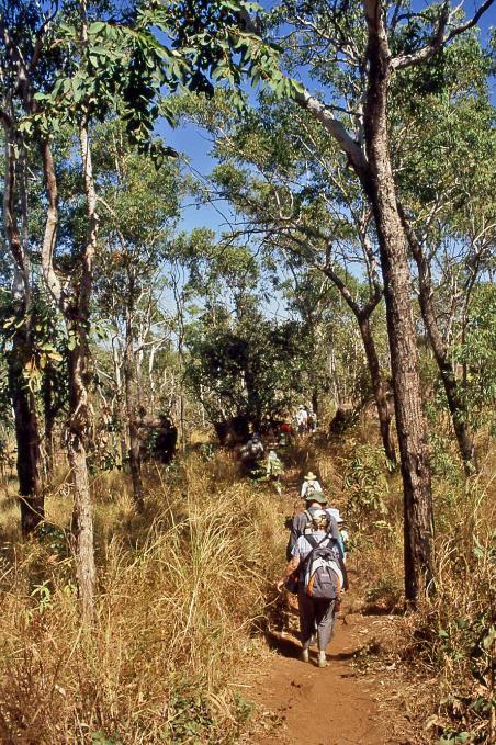
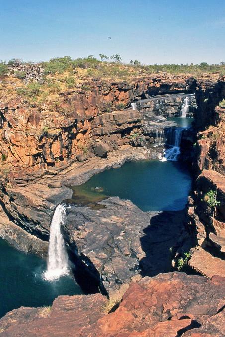
At night, it's the frogs and crickets, but at dawn, it's the birds filling the acoustic background. Their day invariably begins at half-past five. Ours starts slightly later. It's going to be a busy day; just past seven, our bush bus wobbles out of camp. Because today, the famous Mitchell Falls are on the agenda, one of the highlights of the tour.
It's only about twenty kilometres to Mitchell Falls Campground, the gateway to the waterfalls, but it takes us more than three-quarters of an hour to get there. Then we continue on foot to Mitchell Falls. We'll return by helicopter later, in a broad arc along the coast, to also enjoy the landscape from the air and to have a complete overview of the waterfalls.
Even though that flight is scheduled for the afternoon, Jasmin wants to impart her safety instructions to us now. She is from New Zealand, and she has draped a New Zealand flag around her shoulders. It doesn't happen every day, but the circumstances compel her. Last night, the Kiwis crushed the Aussies with a staggering 39-10 in the Bledisloe Cup, a longstanding rugby competition between the two nations. The opportunity to tease our Australian companions – especially the male ones among them – seems too good for the cheerful Jasmin to pass up.
Lack of assertiveness cannot be attributed to her. She confidently lists what we need to do and, more importantly, what we should not do. The latter is emphasized, as bags and loose items are strictly forbidden on board. Vest pockets and pants pockets must be completely empty. A brief glance at the helicopters tells us why. They have no doors. The smallest object caught in the airstream could cause fatal damage to the rear rotor.
The earth is not something; the earth is someone
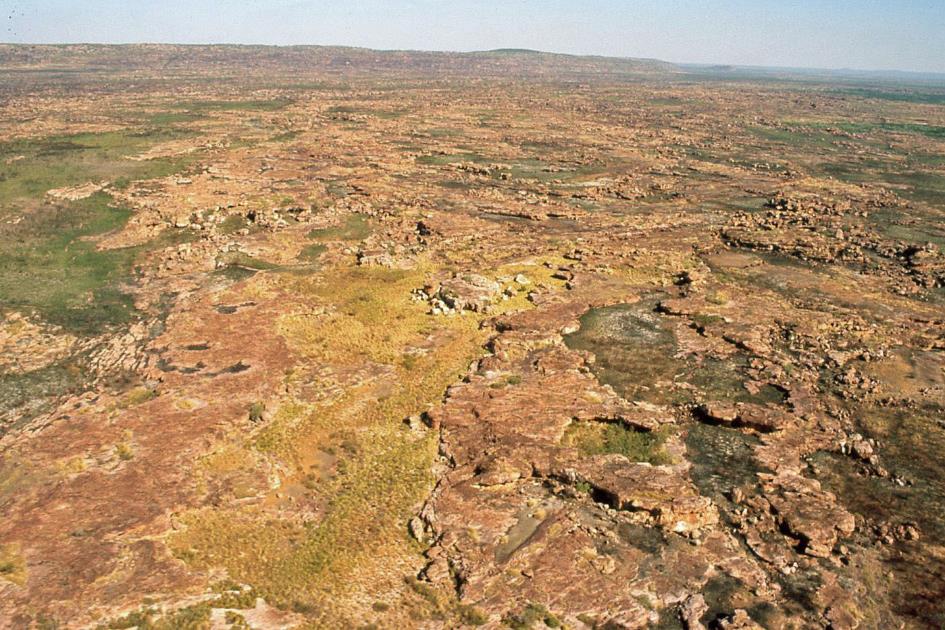
Mitchell Plateau
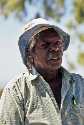
No better guide to lead us to Mitchell Falls, says John, than Chris Brown from the Wunambal. For three hours, Browney, as they affectionately call him here, will take us under his wing and passionately elaborate on this pristine land, with its fauna, flora, and people to whom he has dedicated heart and soul. Later, we will discover that this bush lover conveys his message with just as much passion through his website on the internet.
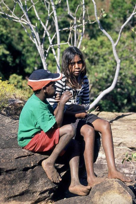
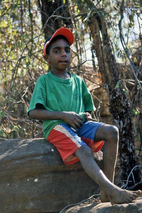
Bernice, Jamal, and Marlene, three children from the nearby Kandiwalgemeenschap, will accompany us. It's clear that the charismatic Browney is held in high regard by them.
Jamal and Bernice |
|
Jamal |
Here, we find ourselves in the living area of the Wunambal, explains Browney, one of the many hundreds of language groups of the original inhabitants of Australia. You can compare these language groups to the tribes among the original inhabitants of the USA, such as the Sioux or the Apaches. Unamii-Unpuu is the name the Wunambal have given to Mitchell Falls for thousands of years, and the area corresponding to Mitchell River National Park is called Ngauwudu.
Browney will first lead us through an area of sandstone, covered with the indigestible spinifex grass, and then through a wooded savannah area. It will be hot and bone-dry, he warns, but during the rainy season, it looks completely different. Because then it rains here on average 1,200 mm, last year even 3,000 mm in just 8 to 12 weeks.
At the time of Captain Cook, the Aboriginals here were better off than the lower social classes in England
The civilization of the Aboriginals has completely different principles than that of the whites, emphasizes Browney. They don't sow wheat or barley; they gather their food from nature. Like, for example, wattle seed, the nutritious seeds of the acacia, or yams, the edible root tubers that somewhat serve the function of our potatoes. Bernice shows us how the unripe leaves of an acacia bush can be used as soap.
|
|
Sand palms |
Their culture is not materialistic like in the West but strongly religious. In that respect, little has changed in the last ten thousand years. However, a monotheistic view of the creation of the earth is foreign to the Aboriginals. Creation, that is something that comes from the earth. All animals are divine. A rock drawing of an animal is the creation of a relationship with that animal. If you kill an animal, you must not completely kill it; you must allow its spirit to return as a new animal. The earth is not something; the earth is someone.
Creation, that is something that comes from the earth. All animals are divine
For tens of thousands of years, the Wunambal have felt at home in Ngauwudu; they hunt and gather their food there. Many stories from the Dreamtime have played out in various places in this environment. For the Wunambal, the places where these events occurred are sacred. Unamii-Unpuu or Mitchell Falls is one of them. Because, just like all rivers and waterholes, these waterfalls were created by the serpent Wungurr. That serpent plays a significant role in most Aboriginal cultures in Australia, albeit under various names. In drawings, Wungurr is usually represented by a rainbow. But that is just one of her many manifestations.
|
|
|
Aboriginals are often considered primitive beings. Completely unjustly, states Browney with conviction, because they are excellently organized. More than just surviving, they have always managed to build a good life. When Captain Cook arrived off the Australian coast with the Endeavour in 1770, the Aboriginals here were better off than the lower social classes in England. Their social stratification is much more horizontally oriented; they do not have a layered society in which some classes are disadvantaged.
Browney shows us part of the brain-like fruit of the pandanus. The fibres of this screw palm are used to weave dilly bags, a traditional carrying bag that Aboriginal women wear over their shoulders when collecting fruits. Wattle seed is very rich in calories and carbohydrates. Bernice has meanwhile gathered salty plums for us, olive-like fruits with an enormous concentration of vitamin C – at least twenty times as much as an orange.
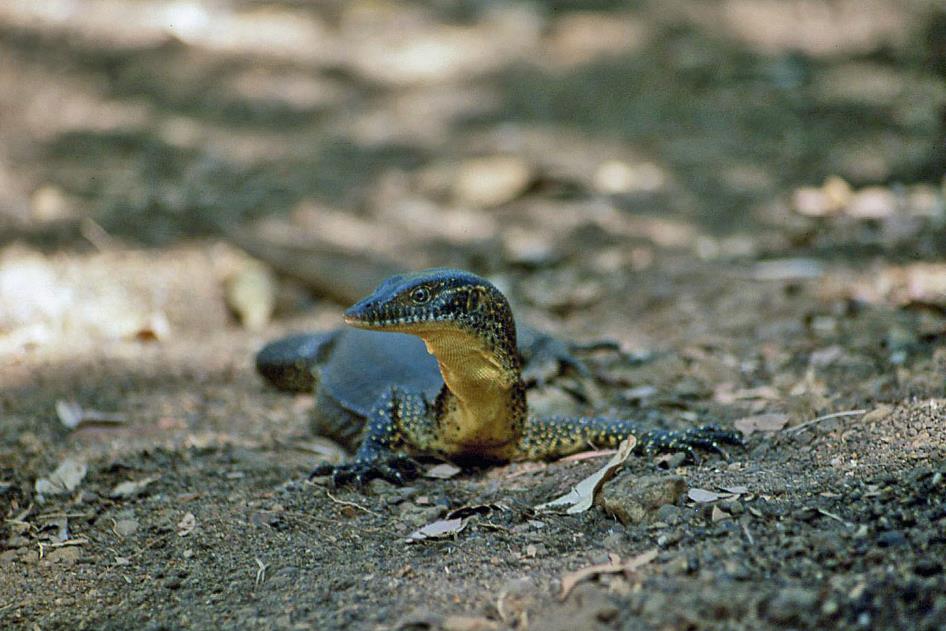
Just like a crocodile, a Mertens water monitor can swim with its nostrils above water
Mertens’ water monitor
In the shade of a tree, a Mertens' water monitor keeps a close eye on us. He is not dangerous to humans, as people are not on his menu; however, crabs, fish, frogs, birds, and small mammals are. Yet, it's better not to corner him, as when he strikes, he can inject a dose of bacteria into your bloodstream that you won't appreciate. He is endemic to the northern states of Australia. Like a crocodile, he can swim with his nostrils above water.
We are approximately as far from the equator as Sudanese Khartoum
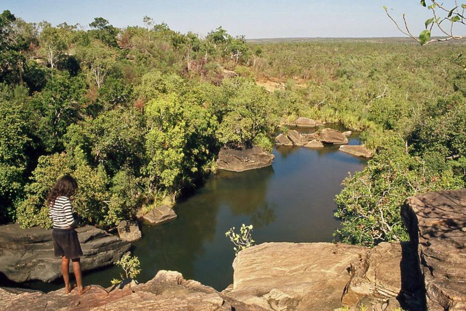
After half an hour of walking, we reach Mertens Little Falls, not as small as its name suggests. Downstream, both banks of the river are hidden under a narrow but dense strip of rainforest. The origin of these trees turns out to be the same as certain trees in India. Not surprising when you consider that Australia and India were part of the same supercontinent, Gondwana, until about 125 million years ago.
Like a giant sponge, the top layer of the Mitchell Plateau absorbs all the water that falls during the rainy season, only to gradually release it the following year. The varying flow of waterfalls like this one is thus a reliable gauge of the amount of rain that fell the previous year.
Two elongated piles of stones on the ground mark the temporary grave of two Aboriginals. The stones prevent dingoes or kangaroos from running off with the remains. After ten to twelve months, the tissue of the bodies will be completely decomposed. The bones will then be collected in a suitcase made of paperbark tree wood and carried to all the places the deceased has been, so that everyone can bid farewell appropriately. We had heard this from John as well.
For Aboriginals, this is a place of worship, the equivalent of the cathedrals for Christians
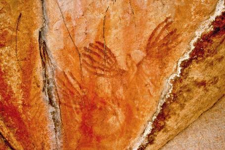
Browney crouches down under an overhanging rock wall. For Aboriginals, this is a place of worship, he explains. You could almost, in a way – taking all proportions into account – call this the equivalent of the cathedrals for Christians. Spread across two galleries, we discern a whole series of rock drawings. The drawings in the upper gallery are older than those in the lower one. In the upper gallery, the white and ochre shades have likely disappeared over time, leaving only the brown-red iron oxide. Handprints on a rock wall are a kind of initiation ritual that newcomers underwent.
Just like the rock drawings from yesterday near King Edward River, these images are part of the Gwion Gwion tradition. Browney cannot provide a definite answer about their age. Some experts estimate them to be twenty-five to thirty thousand years old, while others put it at eight to ten thousand years. Whatever the case, the drawings are much older than the pyramids of Giza, he beams.
Whatever the case, Aboriginal drawings are much older than the pyramids of Giza, Browney beams
|
|
|
No one knows for certain how long Aboriginals have been in Australia. What is certain is that the Kimberley was once deserted. At that time, the sea level was thirty to sixty meters lower than it is today. Eight thousand years ago, it was even one hundred and twenty meters lower. Australia was then twice its current size and almost five times larger than present-day India.
Soil samples from 120,000 years ago are said to contain evidence of systematic bushfires on a scale that only humans could have been responsible for. Many questions can be raised about this hypothesis, but if correct, it would mean that Aboriginals have been here not for the commonly held theory of 50,000 years, but for 120,000 years. This would imply that they knew the megafauna – mammals much larger than their contemporary descendants, such as the diprotodon, a marsupial the size of a hippopotamus. Some stories from tradition and certain rock drawings seem to confirm this hypothesis.
Aboriginals can boast an uninterrupted culture of at least fifty thousand years. No civilization in the world has ever achieved that
In any case, no one doubts that Aboriginals can boast an uninterrupted culture of at least fifty thousand years. No civilization in the world has ever achieved that, Browney concludes entirely rightly.
The ochre-coloured image of a yulamata, an eastern long-necked turtle, prompts Browney to tell us the Dreamtime story of the yulamata of Yalgi. Eating the flesh of such a turtle is strictly prohibited for young people in Aboriginal society. A few youngsters from Yalgi caught a yulamata out of mischief, not only to know the taste of its flesh but also to defy the rules of the elders. They thought no one saw them, but an old man had indeed been watching them. Just as they were about to start eating, he split a gigantic rock nearby with a lightning bolt. That split rock can still be seen in Yalgi to this day.
Yulamata or eastern long-necked turtle (ochre) |
|
Wungurr (serpent), giant yam (on the right) |
Central to this story is the initiation rite of young people, both physical and spiritual. Youngsters are expected to respect this rite. Moreover, Browney adds that Aboriginals actually skip puberty. Once a girl menstruates, she must take on her responsibilities as a woman. Similarly, a boy is chosen at a certain point and subjected to some painful rituals. He undergoes circumcision, and scratches are made on his back with the leg of the long-necked turtle. From then on, he bears the responsibilities of an adult.
Browney crawls tirelessly through the gallery to the next section. On the rock wall, a giant yam is depicted, but the serpent Wungurr also takes a prominent place. The animal is represented as a mythological icon, with the tail of a kangaroo and part of a human arm. Moreover, Browney assures us that we should have no doubt that Wungurr is still present in the waterhole behind us. At the top, we see two snakes, biologically correct, each with two penises.
At the waterhole, the future father receives a dream – if he listens carefully, he can even hear the name of the child
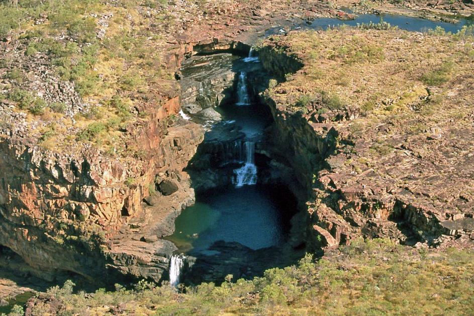
Mitchell Falls
While we continue through the rainforest, Browney explains that every Aboriginal is born from a baby spirit that resides in a waterhole. At the waterhole, the future father receives a dream – if he listens carefully, he can even hear the name of the child. During the night, he transfers this dream to his wife, leading to the rebirth of the baby spirit.
Of course, this cyclical continuum of birth, death, and rebirth only holds if, after the burial and decomposition of the body, the bones are left by the same waterhole from which the baby spirit came. Another future father can then dream of the same child – that's the rebirth.
Browney invites us to fill our water bottles with the crystal-clear water from a stream, as this is the last place suitable for it. Hopefully, we won't get any baby spirits on board.
Upper Mitchell Falls |
|
|
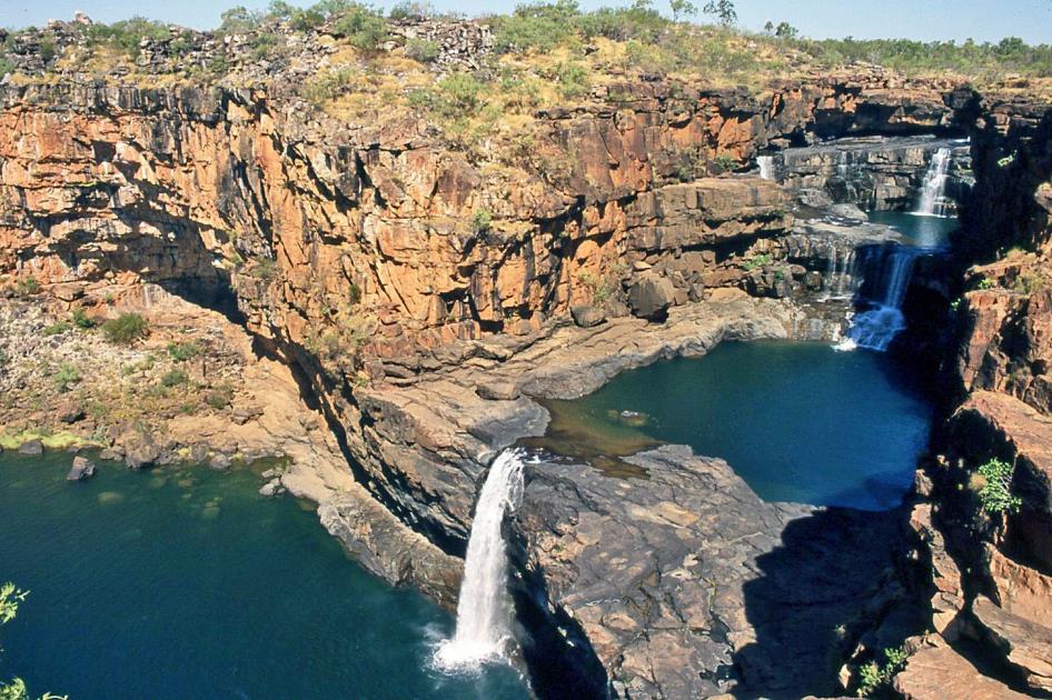
Just before twelve, we reach Upper Mitchell Falls, the northernmost point of our journey through the Kimberley, at almost 15° south latitude. That's approximately as far from the equator as Khartoum in Sudan. With the temperature having risen to 35 °C (95 °F) by now, it's no surprise.
It's the majestic backdrop of Mitchell Falls that holds us captive in this place.
Upper Mitchell Falls
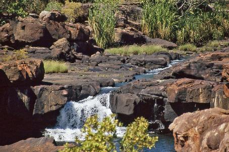
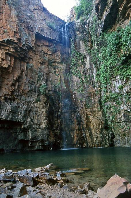
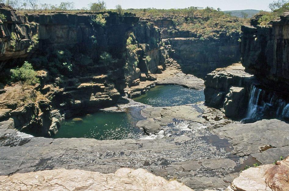
Swimming is not easy here, as the riverbed is slippery, and there are treacherous rocks just below the water surface. But, of course, that's not what we're here for. It's the spectacular waterfalls that immediately captivate us. Mitchell River plunges over a height of eighty meters in four stages down the gorge it has carved into the sandstone rocks over many hundreds of thousands of years.
Mitchell River
Compared to Iguazú Falls or Victoria Falls, it might seem like nothing more than an enhanced bathtub as we look down. However, it's not the flow or the height that these waterfalls boast about. It's the majestic backdrop of the reddish-brown rock walls, it’s the bubbling spectacle of cascading water, it's the green oasis that captivates us in the midst of the barren, rugged surroundings.
Below us unfolds the archetypal bush of the Mitchell Plateau
Higher up the hill is the helipad. Around 2 p.m., pilot Andrew arrives with his Bell 206 for our Coastal Tour. As he fastens our seatbelts, we try to recall the instructions from the mischievous Jasmin.
Walmesly Bay
Andrew promptly heads north towards the coast. Through the open door, we look almost straight down. For now, the landscape unfolding below is not particularly exciting – scattered livistona palms in the savanna grass, occasional rock formations. In short, the archetypal bush of the Mitchell Plateau.
|
|
|
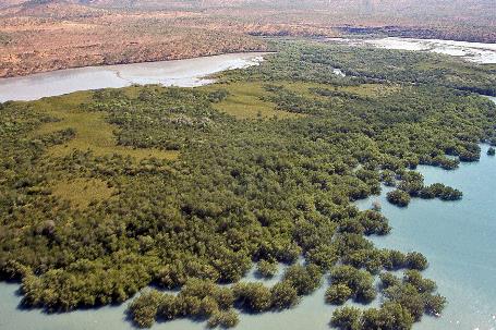
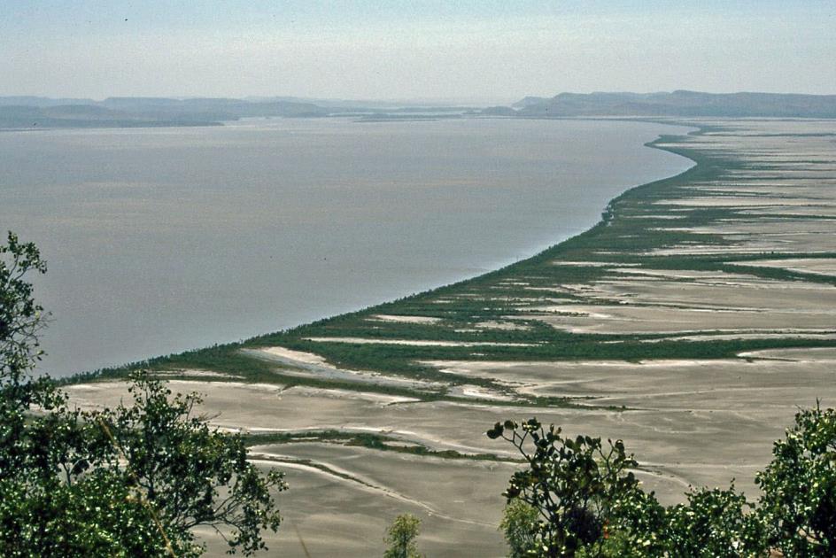
Sometimes, the azure blue water is delicately bordered by narrow white sandy beaches, and at other times, there are extensive mangrove forests off the coast
|
|
|
That changes quickly as we approach the coast. Sometimes the azure blue water of Admiralty Gulf is delicately bordered by narrow white sandy beaches, and sometimes there are extensive dry tidal flats off the coast, surrounded by mangrove forests. Andrew scans the shallow, clear waters of Walmesly Bay in vain for signs of life. Sharks, dugongs, and saltwater crocodiles are what he wants to show us, but they are not cooperating today. Meanwhile, the wind blows with scorching force through the open doors of the helicopter.
Mitchell River |
|
Mitchell Plateau |
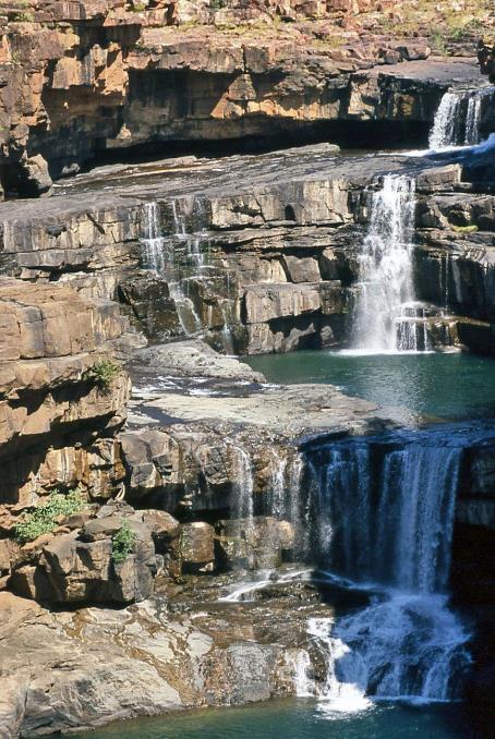
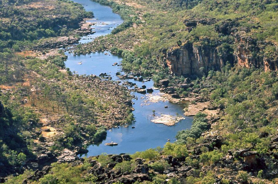
Mitchell River guides us back inland. Only one saltwater crocodile catches our attention, its dark scales shining in the middle of the river. In a wide bend, we now approach the famous waterfalls. First, the falls of Lower Mitchell Falls come into view, with a rather modest drop and at some distance from each other. Then, the magnificent setting of Upper Mitchell Falls appears. It is nothing more than a modest crack in the sandstone plateau, this gorge enclosing the four waterfalls. But now, it becomes truly clear how unique this oasis is, amidst the barren, desolate landscape stretching as far as the eye can see.
Mitchell Plateau
In the evening, at the table in Ungolan Wilderness Camp, we meet Jay, a white teacher from the School of the Air visiting her community and staying here overnight. This distance education in Australia started as early as 1951, initially via radio. In the Kimberley, it wasn't until 1960 that the lessons began. The largest classroom in the world, that's what they sometimes call the School of the Air. Not entirely unjustified, considering that the students are spread over an area of 1.5 million square kilometres.
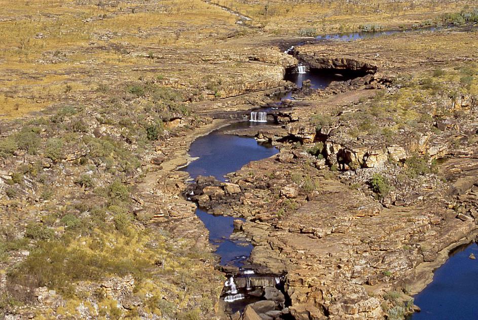
But only now does it become clear how unique it is, this oasis amidst the barren, desolate landscape
Upper Mitchell Falls
About thirty Aboriginal children from the first to the fifth grade take lessons with Jay. Technologically, she is undoubtedly up to date, as she has been using an interactive whiteboard or smartboard for her lessons for two years. The students are located in remote locations but are connected to each other and to the teacher via the internet. Each student can read what appears on the whiteboard, but can also write on it while everyone else watches. Verbal communication, on the other hand, is done in parallel via traditional radio.
The largest classroom in the world, that's what they sometimes call the School of the Air – the students are spread over an area of 1.5 million square kilometres.
But human contact remains indispensable. Therefore, Jay regularly visits her communities, such as today in Kandiwal. Camps are also organized annually on the coast in Derby, where the children can strengthen their bonds with each other.
It quickly becomes chilly around the campfire. By twenty past eight, we are already heading to bed – probably our personal early bedtime record. Gradually, camp life fades away, and only the men from the construction site remain chatting and laughing in their tents, undoubtedly with a few six-packs at hand. A thousand crickets serenade us into the night.
Monday, August 4 | Mitchell Falls – Marunbabidi
Today, we definitively turn our back on Ungolan. Following the same route as the day before yesterday, we find our way back to Gibb River Road, the unpaved track that crosses the Kimberley from west to east, forming the backbone of the rather modest road network in this region.
|
|
|
Following the same route as the day before yesterday, we find our way back to Gibb River Road
|
|
|
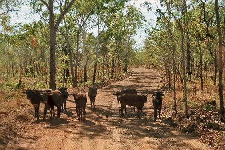
An hour and a half after our departure, eucalyptus trees abruptly replace the palm trees. This sudden transition marks the end of the fascinating Mitchell Plateau. About eight cows stand proudly in the middle of the road and initially show little inclination to move away. As if they prefer us to stay a little longer.
King Edward River
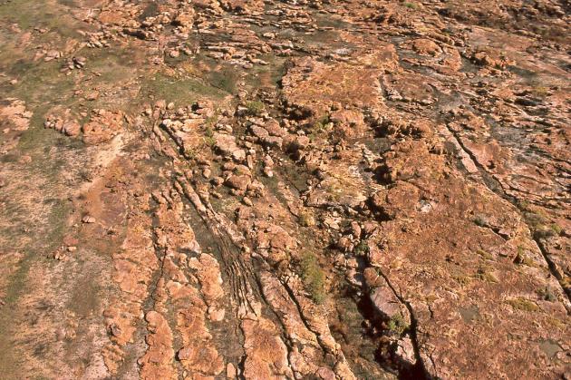
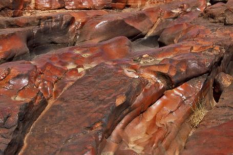
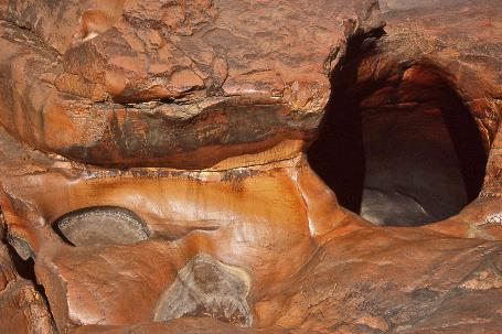
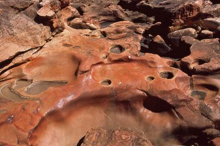
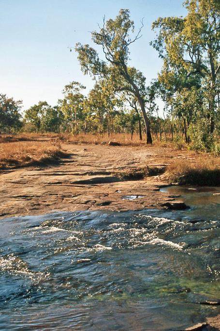
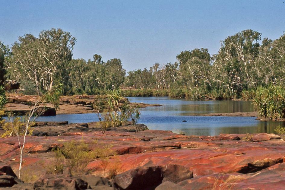
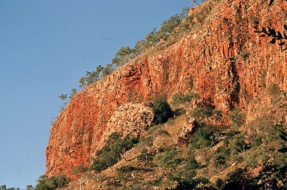
A bit later, we reach the bank of the King Edward River. In the rocky bed, the river has carved out a rather decent waterfall. Admittedly, it doesn't come close to Mitchell Falls. However, it's not so much the waterfall that captivates the imagination; it's the bizarre terrain next to it. It's a tangle of brown rocks, glistening in the sun as if a giant hand has polished them. Most of the rock blocks have deep holes with an almost perfect cylindrical shape, as if that same giant took a moment to drill after polishing.
|
|
|
A tangle of brown rocks, glistening in the sun as if a giant hand has polished them, with deep holes in an almost perfect cylindrical shape
King Edward River |
|
|
However, this is the work of nature. When the wild rainwater seeks its way across this terrain during the rainy season, it carries various pebbles with it. These pebbles polish the rock surface, causing it to shine in shades of brown, red, and black under the radiant sun during the dry season. If these pebbles end up in one of the holes, they are caught in a tumultuous whirlpool and, on their circular paths, gradually carve out larger holes.
We spot some rock formations in the distance. By now, we know what that means. Rock paintings are on the way
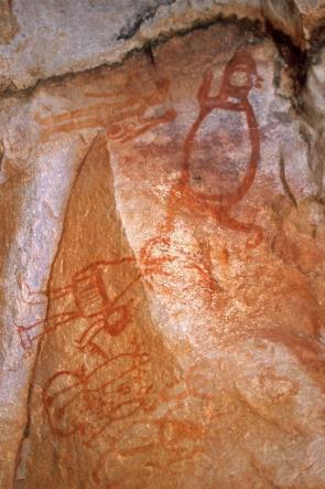
We explore the area a bit, take a few laps in the water, have lunch, and then continue our journey. Only for a short while, as suddenly John steers his bus back into the bush. Between the trees in the tall savannah grass, we spot some rock formations in the distance. By now, we know what that means. Rock paintings are on the way. As usual, John doesn't say much about it beforehand. The surprising encounters, therefore, have a greater impact on us.
Paintings from the Gwion Gwion period are somewhat familiar to us. As is often the case, some very old images here have been overpainted with more recent work. John points out, among other things, the moralizing depiction of some young troublemakers who have nothing better to do than make life difficult for an owl by plucking its feathers. This does not go unpunished, as a spirit from the forest does not let them get away with it. Not all the images on the rocks are equally clear; often, they are vague, challenging to interpret sketches.
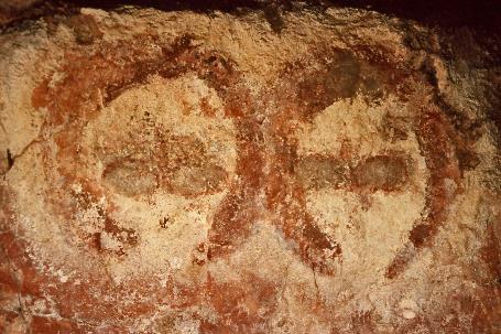
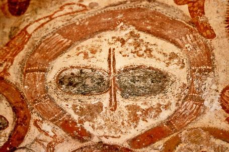
Then suddenly we come face to face with a stunning scene. Six large pale heads stare at us from the rock wall
. Wandjina's with a giant kangaroo
Wandjina |
|
Extra-terrestrial beings? |
But then we suddenly come face to face with a stunning scene. Six large pale heads stare at us from the rock wall. They are otherworldly beings, or so it seems, with heads like perfect circles, two dark, elliptical eyes, and a vertical line in between that might represent the nose. So unearthly that the Swiss pseudoscientist Erich von Däniken did not hesitate to call these the portraits of beings from another planet.
Human and animal figures |
|
Bird figure |
And he had more than one reason for that. Because Aboriginals call these beings Wandjina's, spirits of ancestors who come from space and control the natural elements. On the ceiling above the Wandjina's, a large kangaroo is depicted in red ochre. It is part of the scene. According to the Dreamtime stories, six Wandjina's were passing through here when they caught and devoured a kangaroo. Not exactly a story that keeps you on the edge of your seat. Yet, it has led to this world-famous fresco.
Wandjina's will only be found in the Kimberley
The contrast between these Wandjina's and the Gwion Gwion style we learned about earlier is striking. Gwion Gwion may be the oldest of the two styles, yet it excels in the fine lines and rich detail of the drawings. Typically, the figures are depicted in profile, with lush hairstyles and ornaments on the chest, arms, and legs. They are often shown dancing or hunting.
Turtle, human figures |
|
Extra-terrestrial being? |
|
Turtles |
Wandjina, on the other hand, relies on broad strokes of paint in red, yellow, white, and black. The figures are static and stylized, large and anthropomorphic. They are usually surrounded by animals and plants. Wandjina's can only be found in the Kimberley, while Gwion Gwion can be found elsewhere as well.
We cross the fairly deep King Edward River and reach Kalumburu Road about fifteen minutes later. This road leads us southward, roughly parallel to the river. Compared to the roads we encountered on the Mitchell Plateau, the unsealed Kalumburu Road seems like a highway.
River crossings |
|
|
Just before half-past three, we take the westward turn towards Marunbabidi. Ten minutes later, our bush bus once again plunges into the waters of King Edward River. We pause briefly on the riverbank and then make our way to Marunbabidi Wilderness Camp. With 19 permanent tents, this tented camp nestled among the trees on the riverbank is somewhat smaller than the previous one.
Our instructions here are decidedly more prosaic than before. Tomorrow morning, we are to check all our belongings before use, especially our shoes. Spiders capable of delivering a venomous bite might have taken residence. To discourage these arachnids, they have covered the gaps in the plank floor of the tent with a tarp here, unlike in the other tented camps. And if we feel an unstoppable urge to add more wood to the campfire later, it would be wise to ask the staff to do it for us. A few days ago, when a tourist picked up a piece of wood, it turned out a snake was hiding underneath. Both the tourist and the snake survived.
|
|
|
Completely reassured, we retire to our tent for the night. This time it's called Rufous Whistler, a reference to a songbird found only in northern Australia. True to its name, its plumage may appear dull, but it excels at whistling.
The misconception that all our travel companions would be Australians comes to light during a friendly chat around the evening campfire. Almost thirty years ago, Ernie and Margaret emigrated from the United Kingdom to Australia, but they still haven't relinquished their British passports. Aussies have coined a playful acronym for such individuals – POME, a term referring to prisoner of mother England.
When they emigrated in 1980, Ernie and Margaret, along with their three children aged 7, 13, and 14 at the time, had two certainties: a furnished house awaited them in Australia, and Ernie had a job. However, upon arrival, Ernie's job was nowhere to be found, and the furniture in the house consisted of nothing more than a kitchen table and some bed frames without mattresses. Margaret adds that it smelled terribly, and she vividly remembers opening the table drawer upon arrival and bursting into tears at the sight of a few spoons and forks. Yet, they made it work. Ernie hit the streets immediately, and by nightfall, he had secured a job. They have no regrets, and the thought of going back never crossed their minds.
Aussies have coined a playful acronym for such individuals – POME, a term referring to prisoner of mother England
Now retired, they have been on the road with their caravan for eighteen months. True grey nomads, they are doing what grey nomads are supposed to do – SKI, Spending the Kids Inheritance. Their house has been rented out all this time, and their furniture is neatly stored in a container. At the end of this year [2008], they plan to conclude their nomadic life and settle down permanently.
Marunbabidi Wilderness Camp
So much for the plans. Because around Christmas, they will let us know that they still want to travel through Tasmania for two more months and then escape the cold winter in tropical Queensland. Settling down permanently, they plan to do that in October of next year [2009]. We'll believe it when we see it.
Tuesday, August 5 | Marunbabidi – El Questro
Scarcely have the birds started their serenade at half-past five, and our camp instructions vividly come to mind. Checking our shoes thoroughly for spiders was the motto. But that turns out to be completely unnecessary. Judging by the rich collection of welts on our bodies, those voracious spiders have already done their work in bed last night.
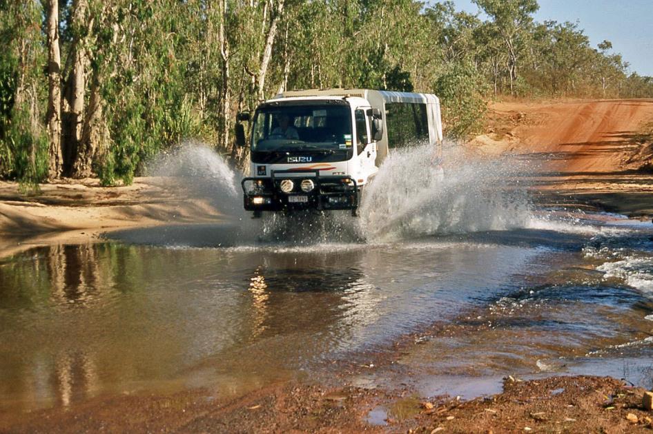
In a fountain of splashing water, John crosses Drysdale River with his 6WD bush bus.
On the way to Kalumburu Road, we plow through King Edward River one last time, and three-quarters of an hour later, it's Drysdale River's turn. John has a good understanding of the travel memories tourists like to cherish. So, he drops us on the other side of the river and returns alone with his bush bus, allowing us to capture his river crossing in a fountain of splashing water on film. Ten minutes later, we make a brief stop at Drysdale River Station. The phone booth, aka the refrigerator, is still in service.
Just before ten o'clock, we reach the good old Gibb River Road and continue our journey eastward toward the coastal town of Wyndham.
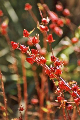
A shady spot by a creek with many rosella bushes under the trees happens to be aptly named Rosella’s Flats. This is rather coincidental because the rosella is a parrot-like bird, while the roselle is a hibiscus-like plant. Its fire-red leaves are sometimes used to make jam, but we find them quite sour.
White-faced heron |
|
Roselle |
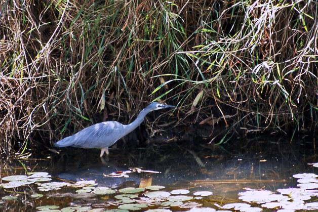
Blue water lilies float motionless on the smooth water surface. Among the grass on the steep bank, a water monitor rustles for a moment, but it dives shyly into the water as soon as it senses our presence. On the other hand, a white-faced heron is not easily deterred. Calmly, it wades through the water in search of prey. It is relatively small in stature but not easily intimidated. White-faced herons have even been observed on some subantarctic islands.
River crossing |
|
Pentecost Valley |
A few waterholes aside, Durack River is dry today, but during the wet season, it becomes a wide, mighty river. However, caution is advised because the river contains saltwater – saltwater crocodiles feel at home here. The river takes its name from the Duracks, a powerful family that played a significant role in the development of the Kimberley.
Corrugations give you the feeling that your vehicle is rumbling over a giant washboard
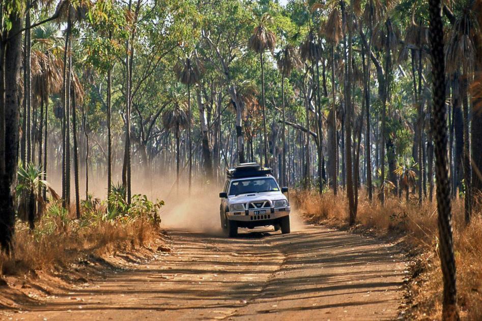
It must be said that while Gibb River Road may be the main unpaved road in the Kimberley, it is certainly not the best unpaved road. This is almost exclusively due to the corrugations, the aggressive ripples that spontaneously form in the gravel. No track in the outback escapes them. They appear as if deliberately arranged by human hands, lying there so neatly in parallel lines across the direction of travel, with approximately twenty centimetres between each. They give you the feeling that your vehicle is rumbling over a giant washboard.
Cockburn Range
How these corrugations come about is well known. When a vehicle travels at a sufficient speed over smooth gravel, its wheels will no longer roll smoothly over the road surface but bounce slightly. Gravel stones are pushed into heaps, creating transverse ridges. This phenomenon seems to occur at speeds as low as 8 km/h. The heavier the vehicle, the greater the effect, of course.
When we were still traveling with our 4wd, we didn't quite know how to handle it. Australians had told us to drive over them at sufficient speed – 70 to 90 km/h – because then you sort of float over the irregularities, and you don't feel the shocks. It seemed like dangerous advice to us. Racing over gravel at such speeds is a risky endeavour, especially in curves or when braking. Yet, that's exactly what John does with his 6wd. We hover over the ridges at breakneck speed. Torture for humans, torment for the vehicle.
Next to the road, traffic signs surprisingly appear to warn us in time of imminent danger. Floodways, for example, are broad, shallow flood areas where water gathers during the rainy season and can flood the road, but are entirely harmless in this season. Or dips, deep, steep trenches across the road that can cause damage to the vehicle even in the dry season. Perhaps the most dangerous are the crests, steep ridges across the road, as you cannot see oncoming traffic, and the risk of a head-on collision on top of the ridge is real.
To spare cattle trucks, the steepest slopes are equipped with strips of asphalt – they call them jump-ups here. Some curves are even marked with reflector posts – an unprecedented luxury in the Kimberley.
We look out over one of the most iconic scenes of the Kimberley and even of Western Australia
Pentecost River crossing, Cockburn Range
Just before one o'clock, we commence the ascent of the Pentecost Range. Before we know it, we gaze upon one of the most iconic scenes of the Kimberley and even of Western Australia. In the foreground, the stately Pentecost River crosses our Gibb River Road, while in the background, the colossal table mountains of Cockburn Range rise as an imposing wall above this vast amphitheatre. As far as the eye can see, there is nothing but bush.
Even at this time of the year, the river is several tens of meters wide and flows quite swiftly. There is no bridge, but vehicles have no choice; they must brave the water crossing. Or they can backtrack several hundred kilometres and follow the Great Northern Highway, as happened to a German couple with a motorhome.
The presence of saltwater crocodiles in this mixture of salt and freshwater cannot be ruled out, John notes. But for now, we don't notice anything.
Emma Gorge
With the impressive Cockburn Massif on our left side, we continue our journey. Baobabs are once again part of the scenery. One and a half hours later than planned, we reach Emma Gorge, reportedly one of the most beautiful gorges of Cockburn Range. A quick picnic in the grass, and then we set out on foot.
Emma Gorge is said to be one of the most beautiful gorges of the Cockburn Range
Emma Gorge |
|
|
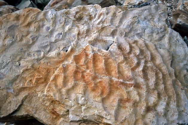
For about an hour, we scramble over rocks in what looks like an old riverbed. Graceful grooves on some stones reveal that in fact we are on an ancient seabed. Those grooves are the fossilized wrinkles in the sand from shallow tidal waters.
Fossilized wrinkles in the sand of shallow tidal waters. |
|
|
The gorge now becomes narrower, eventually leading to a magnificent setting. Surrounded by a sheer, horseshoe-shaped wall, a waterfall cascades down from a height of 65 meters into a permanent pool. Only the bravest dare to take a dip in that icy-cold water.
Continuing through a narrow valley, we encounter trees, something we're not accustomed to. In complete darkness, we reach El Questro, our resting place for the night. With an area of a million acres or about 4,000 square kilometres, this private estate is as large as Rhode Island. In fact, it is still pure wilderness; it was officially registered only in 1958. Whoever owns El Questro can consider the entire Cockburn Range as their backyard, including the drainage area of four rivers – Pentecost, Salmon, Chamberlain, and King.
El Questro’s private estate of is the size of Rhode Island
Playing the role of a cattle farmer in this region requires a certain skill set. Driving cattle on horseback or by motorcycle, as is customary elsewhere, is not feasible here given the enormous distances. Instead, helicopters are preferred. Cattle are herded towards Wyndham, a seaport about a hundred kilometres to the north. From there, the animals are shipped to Indonesia.
The fact that the estate has changed ownership several times is not surprising. It is currently for sale. For a tidy sum of 5.6 million euros, El Questro could be our plaything. That's only 14 euro cents per square meter. A bargain indeed.
But running El Questro as a cattle farm is a thing of the past. Tourism has proven to be a much better use for this estate than cattle farming. So, it's not much of a surprise that our bungalow is comfortably equipped, including air conditioning. Although tonight, we'd prefer it warm rather than cold.
Wednesday, Augustus 6 | El Questro – Kununurra
It can hardly be called a morning serenade, the hoarse cries produced by some crow-like birds from half past five. Behind our bungalow, the Pentecost River flows gracefully between the paperbark trees and the pandanus.
With a kookaburra around, snakes are not safe
|
|
Blue-winged kookaburra |
Also, a few blue-winged kookaburras are present. These are quite large and robust birds, undoubtedly the most characteristic ones in Australia. Originally found only in the east, they were intentionally introduced to the west from the beginning of the last century. This was mainly due to their reputation as predators – with a kookaburra around, snakes are not safe.
Despite being classified as kingfishers, kookaburras do not behave like typical kingfishers. They are not interested in the proximity of water, and they won't bother getting their feathers wet for a fish unless strictly necessary. They prefer to live in dry forests and feed on lizards, mice, insects, worms, and, of course, snakes.
Despite being classified as kingfishers, kookaburras do not behave like typical kingfishers
Blue-winged kookaburra
They are sometimes called laughing birds because their call strongly resembles human laughter. As charming as that may sound, it's best to be on guard when they are around. Not only can they catch snakes, but they are also not hesitant to snatch food from picnickers. So, it's a good idea to be cautious during breakfast on the covered terrace.
A property of around a million acres, like El Questro, is not exceptional here, as we learn from a casual breakfast chat with fellow travellers George and Margaret. And they would know, as they operated a cattle farm in New South Wales during their active life, primarily focusing on milk production and to a lesser extent on meat production. However, in the Kimberley, keeping dairy cattle is not feasible. The land is so poor that cows have to spread out over a vast area to find enough food. Try milking them every day in such conditions. If cattle are raised in the Kimberley, it's solely for meat production.
And how do you acquire land in an area where nobody lives? In the old days, you could claim ownership once you settled on a piece of land. But those pioneer days are long gone, George chuckles. Land not in private hands automatically belongs to the government.
If the cows spread out over an area the size of Rhode Island, try milking them every day
But even on your private land, your property rights are not unlimited. Anything deeper than 9 feet – approximately 2.75 meters – beneath the ground belongs to the government. If a company obtains a concession, say for gold mining, it can operate beneath your property without your permission, as long as it doesn't disturb your 2.75 meters.
It used to be different. Until 1850, the land was entirely yours, figuratively speaking, down to the centre of the Earth. This included groundwater and even the water of a river flowing through your estate. George knows of an estate acquired in private ownership in 1848, and the owner still has all rights to the groundwater and river water.
El Questro's reputation as a tourist destination has been able to grow, partly due to Zebedee Springs, a hot spring about six kilometres away. John drops us near the location. Through dense vegetation, we follow a short path to the base of a sheer rock wall. We gaze at a sandstone formation that is a whopping 1.8 billion years old. They call the rock King Leopold Sandstone. Apparently, Leopold II managed to anchor his name even in geological nomenclature.
Amid lush vegetation of livistona and other plants, we discover an abundance of pools and tiny waterfalls. The hot water comes from a permanent reservoir deep in the earth and is forced upward through a fault line in the rock under pressure. Cascading, it finds its way through the plants and over the rocks, gradually cooling. Yet, the water temperature will remain fairly constant at 28 to 32 °C (82 to 90 °F) throughout the year. Here and there, pale tourists have claimed the natural tubs among the rocks, sometimes with a waterfall as a shower nearby. We resist the temptation.
Five Rivers Lookout
With the majestic Cockburn Range on our left and the gigantic plume of smoke from a robust bushfire on our right, we continue our journey just after ten. Forty-five minutes later, the unsealed Gibb River Road comes to an end, and we rediscover the comfortable asphalt of the Great Northern Highway. It's pleasant, no doubt, but we immediately feel a longing for the real Kimberley.
We rediscover the comfortable asphalt of the Great Northern Highway. It's pleasant, no doubt, but we immediately feel a longing for the real Kimberley
We quietly zoom northward over the smooth asphalt towards the port town of Wyndham on the Joseph Bonaparte Gulf, named after Napoleon's older brother. This was the only gateway to the Timor Sea for the eastern part of the Kimberley. Live cattle were shipped to Indonesia from here. In 1913, a meat processing plant was established, which lasted until 1986. However, nowadays, the vast town looks lifeless. There's hardly any movement on the streets or around the houses. Perhaps the midday temperature of 33 °C (91 °F) has something to do with it.
Five Rivers Lookout
Five Rivers Lookout is the main, if not the only, attraction of Wyndham. The relatively steep slope challenges our bush bus. Once at the top, we enjoy a fabulous panorama of almost 360° over the confluence of five of the mightiest rivers of the Kimberley – the Durack, the Pentecost, the King, the Ord, and the Forrest. To the southern horizon, the table mountains of Cockburn Range dominate, to the north, the mudflats stretch out as far as the eye can see, and at our feet lies the modest harbour of Wyndham.
|
|
Ord River Valley, Cockburn Range |
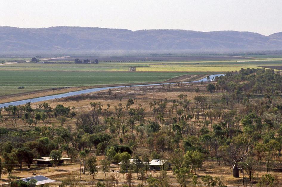
A one-and-a-half-hour drive brings us to Kununurra, a town on the eastern edge of the Kimberley. This place is home to a whopping six thousand inhabitants, including a thousand Aboriginals. Without exaggeration, such a population concentration may be considered a metropolis. A short climb later, we find ourselves at Kelly's Knob. The view over Kununurra is satisfying, but it cannot quite compare to that of Five Rivers Lookout. Vast green, yellow, and brown rectangles colour the landscape, an image that we are no longer accustomed to. These are fields and farms that have been made fertile through hard work in this arid region. In the distance, a tractor raises a long dust cloud as it prepares fallow land for the next harvest. Further on, the inhospitable wilderness stretches to the horizon.
Vast green, yellow, and brown rectangles colour the landscape, an image that we are no longer accustomed to
We still have some time to explore Kununurra on our own. This leads us to Our Land Gallery. The contemporary artworks displayed here by Aboriginal artists momentarily overwhelm us. Several rooms are filled to the brim with outstanding creations by local artists.
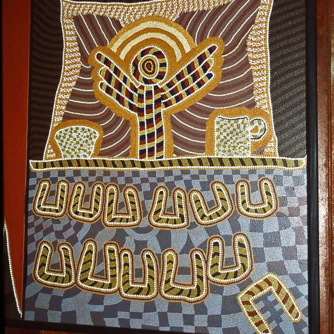
We were already familiar with the ancient graceful figures of the Gwion Gwion style and the mysterious Wandjina figures. However, here, contemporary artists take the lead with their excellent works in the Papunya Tula style. At first glance, these are enigmatic works, challenging to comprehend with our Western perspective. Yet, they grip you with their intricate patterns, strange forms, circles and horseshoes, and vibrant colour palettes. And always those round dots, sometimes numbering in the hundreds.
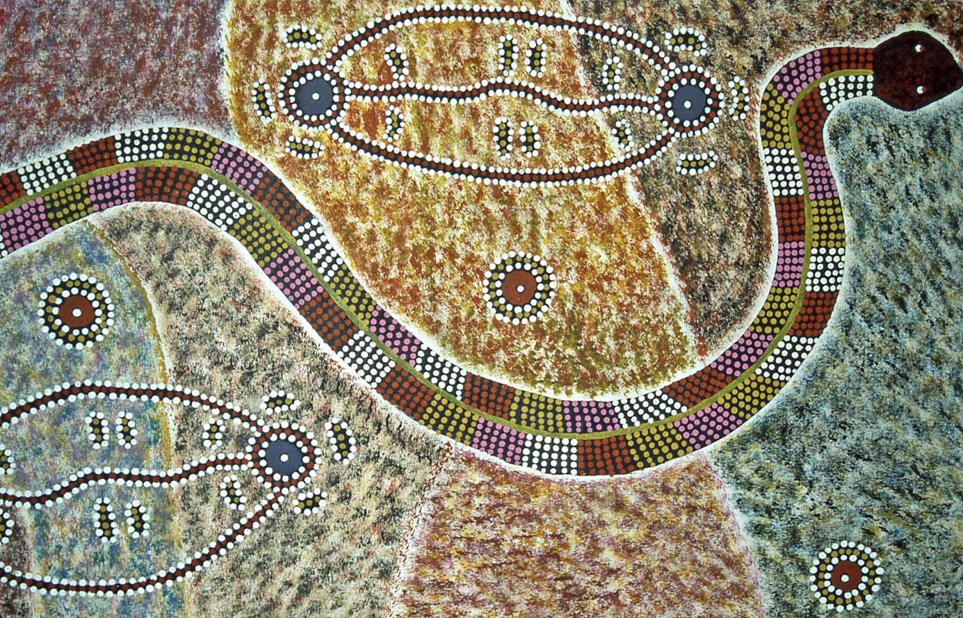
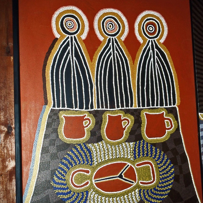
Papunya Tula style – The Serpent Wungurr1)
Papunya Tula style with a Christian motif – |
|
Last Supper with bush tea and damper (unleavened bread). Judas turns his back on the group< |
The recognition grows as we learn more about the origin of this art form. The story dates back to 1971 when Aboriginal men from the small community of Papunya, not far from Alice Springs, began exploring a new art form. The motifs they used were not new, as they still depicted traditional stories from the Dreamtime – although more recent motifs also emerged. What was new was the medium they used: painting on canvas. For thousands of years, they had created drawings in the sand or painted their bodies during ceremonies. Now, they were transitioning to canvas, the medium of the white colonizer.
The movement quickly became a great success. Since then, the Papunya Tula style has evolved into one of the most recognizable art forms in Australia. These works effortlessly compete with creations by white artists. They even embrace typical Christian motifs such as the visit of the Three Wise Men to the newborn Jesus or the Last Supper.
The tragedy of the Aboriginal community remains immense despite increased recognition and appreciation
As soon as we step back onto the street, a trio of dishevelled Aboriginal men crosses our path, staggering and making lewd remarks. It's a punch in the stomach, transitioning from one reality to another. The situation of many Aboriginal communities remains precarious, whether they live in a remote area, in one of the returned natural reserves, or in one of the major cities. Their economic well-being, health, and overall welfare still leave much to be desired, underscoring the immense tragedy of this community despite increased recognition and appreciation.
Jaak Palmans
© 2024 | Version 2024-01-22 16:00
Continue reading in (3/3)
1) The displayed works in the Papunya Tula style are housed in the Australian Museum (Sydney).