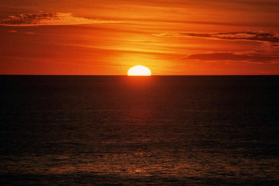
There’s nothing there, absolutely nothing
Australia | Anno 2008
Wednesday, July 30 | Broome – Imintje
Friday, August 1 | Imintje – Drysdale River
Prologue | Broome
They don't have gutters here, and freestanding mailboxes are also absent. That's not negligence; on the contrary, it's anticipating what's to come. Because gutters and mailboxes are simply the first casualties when a tropical cyclone passes through. And cyclones are not uncommon here. However, this doesn't give us cause for concern. The Current Cyclone Status, as we read on a sign when entering the town, is All Clear.
There in the north, they said, there is nothing. Absolutely nothing
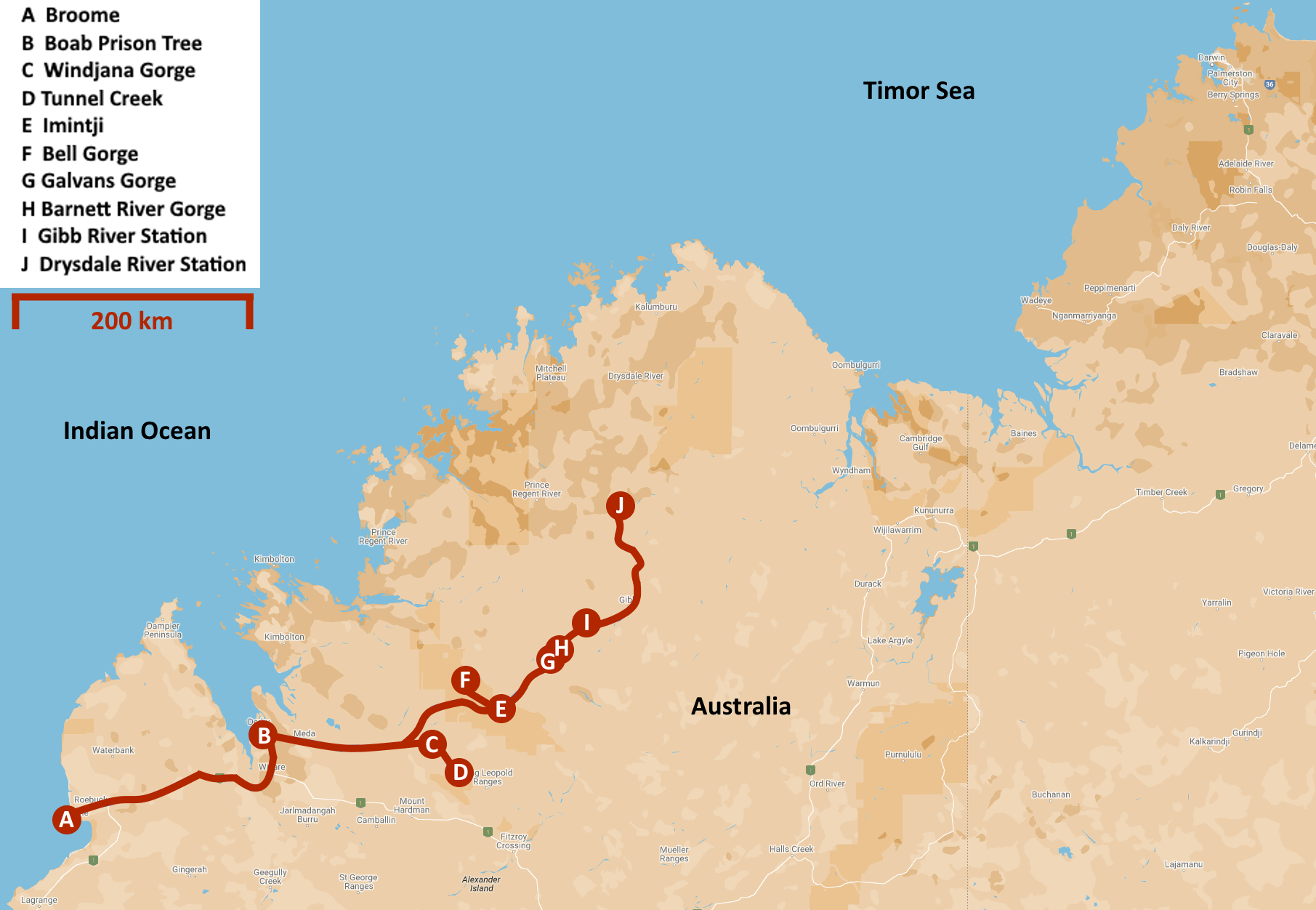
After three weeks of touring Western Australia, we have arrived in Broome, a town of fifteen thousand inhabitants in the far northwest corner of this vast continent. From here, we will embark on our journey through the Kimberley.
We have just under six hundred kilometres on the odometer since leaving Port Hedland this morning. During this time, there was no sign of human habitation along the Great Northern Highway, excluding three roadhouses. Encounter with oncoming traffic was also minimal. Yet, they had warned us about that in Perth when we outlined our plans to head to the Kimberley. There in the north, they said, there is nothing. Absolutely nothing.
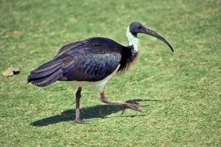
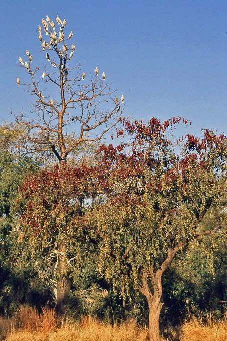
Straw-necked ibises |
|
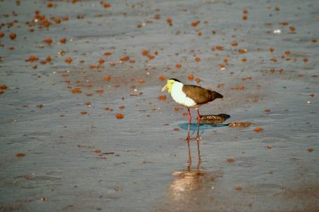
Masked lapwing |
It says something about this country. With an area of 2.5 million square kilometres, Western Australia is by far the largest state in Australia, larger than Norway, Sweden, Germany, France, Italy, and Spain combined. Yet, only two million people live here. That's not even one Aussie per square kilometre. Three-quarters of them are clustered around the capital, Perth.
And yet, in this remote corner, the bustling town of Broome has flourished. Together with the port town of Derby, about two hundred kilometres away, it is the only significant settlement within a radius of five hundred kilometres. This corresponds to an area about the size of Italy.
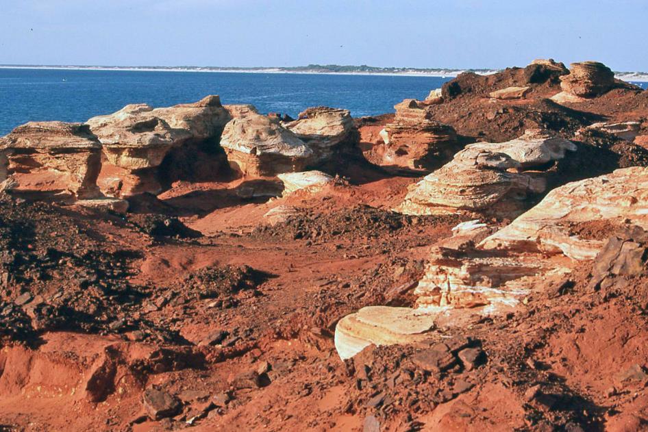
Broome – Gantheaume Point – Brownish-red sandy clay (pindan)
Explaining this unique position doesn't take long. The history of Broome reads like the history of the pearl industry. Broome even calls itself the pearl capital of the world. Before exploring the desolate Kimberley, we are immersed in a completely different world. Because a visit to a pearl farm is unavoidable here.
For centuries, Aboriginals have been diving for mother-of-pearl here, we learn. They didn't venture deeper than 15 meters because they had no form of protective equipment. From 1880, things changed when whites appeared on the scene. They initiated commercial pearling and introduced a primitive form of diving equipment. But they avoided the dangerous work, leaving it to be done by Aboriginals.
Legendary are the achievements of divers like Takata, who suffered from decompression sickness more than forty times, and Ejiri, who never got it
It didn't take long for the government to prohibit this practice. This led to the involvement of Asians willing to leave their poor fishing villages in hopes of a better life. Japanese, in particular, gained a reputation as skilled divers, while Koepangers – residents of the city of Koepang on the Indonesian island of West Timor – manned the pearling luggers. Around 1900, more than four hundred pearling luggers called Broome their home port.
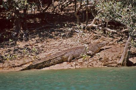
Saltwater crocodile (‘saltie’) |
|
|
Originally, those divers were equipped with a copper helmet, a rubber suit, and shoes with a copper tip. Two men worked together, a tender on board the pearling lugger and a diver in the water. The diver communicated with his tender through a rope of 50 fathoms – a little more than 90 meters. Fresh air was supplied to the diver through a hose. Two men continuously pumped air into it.
Later, this pumping was taken over by a machine. Seemingly an improvement, but in practice, the consequences were dramatic. This technology allowed diving deeper than before, causing Broome to quickly experience decompression sickness. If a diver ascends too quickly to the surface, nitrogen bubbles form in his blood vessels. These bubbles impede blood circulation, which can lead to paralysis and even death. Legendary are the experiences of divers like Takata, who suffered from decompression sickness more than forty times, and Ejiri, who never had it.
It was only in 1914 that the decompression chamber was introduced. Divers who fell victim to decompression sickness were subjected to increased air pressure, after which the pressure could be gradually reduced. The result was spectacular. Between 1910 and 1914, 92 divers lost their lives, but in 1915, only one.
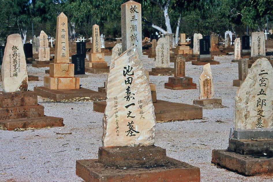
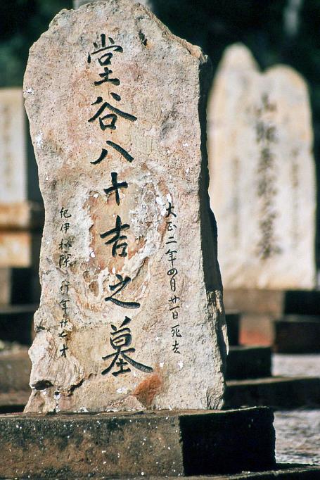
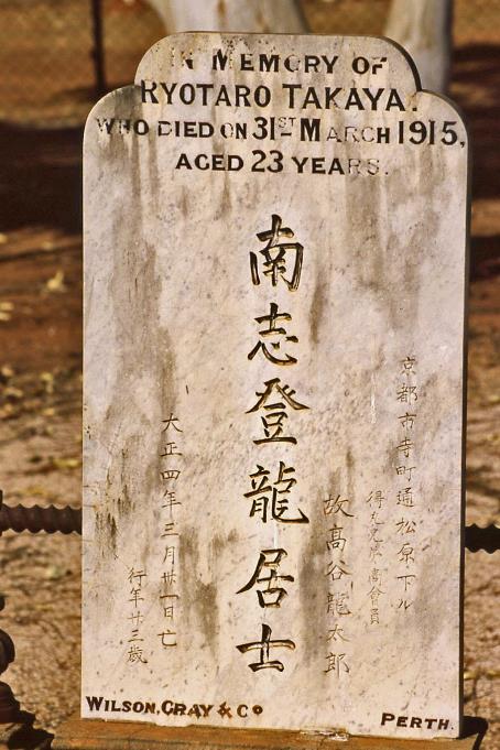
Broome – Japanese cemetery
That Broome retains a substantial Japanese cemetery from that turbulent period is not surprising. 707 graves are marked by simple beach rocks. Only young men are buried here, succumbed to the consequences of decompression sickness, killed by a shark, or simply drowned. The oldest grave dates back to 1896.
Graves of Japanese pearl divers |
|
|
The Second World War marked a significant turning point. There was a deep fear that the Japanese would invade this area. Broome was even bombed, and women and children were evacuated to the south. All Japanese divers were thrown into prison, and all pearling luggers were burned for fear of falling into enemy hands.
Afterward, pearling never reached the pre-war level. Around 1980, commercial pearl diving definitively came to an end. But not the pearl industry itself. In the meantime, pearl farming had flourished. Instead of collecting wild shells in the hope of finding a pearl inside, they started lending nature a helping hand.
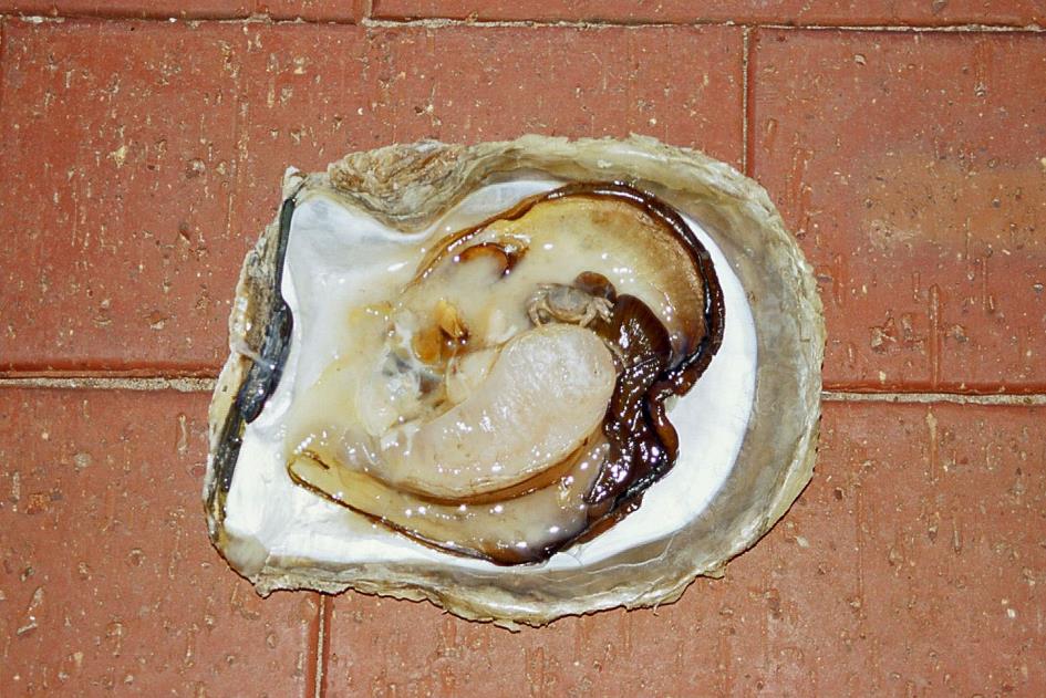
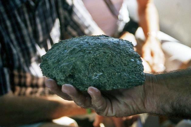
Opened pearl oyster with small pea crab
Pearls are the result of a defence mechanism of these molluscs. When a parasite or a piece of debris enters the shell, the oyster works to neutralize the intruder by encasing it in layers of nacre. Typically, this occurs against the inner surface of the shell, leading to a thickening of the shell that is not useful. However, occasionally, this process takes place within the tissue of the animal itself, giving rise to one of those coveted free-floating pearls.
Moreover, almost all pearl oysters tolerate the presence of a cleaner within their shell. This is often a small pea crab that, in exchange for safe shelter, keeps the outside of the shell clean.
Broome even calls itself the pearl capital of the world
Closed pearl oyster |
|
Pearl oyster cultivation |
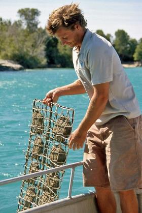
When it comes to pearl production, the key is to involuntarily set the pearl oyster to work. This is done by inserting a foreign object in the right place, typically a piece of mother-of-pearl from a freshwater mollusc from the Mississippi. Once the shells are ready for this process, they are opened one by one. Only a very small amount, and not longer than 40 seconds, as they otherwise die. For skilled workers, that's enough to make a precise 5 mm incision in the gonad and place the nucleus inside. Additionally, a piece of mantle is added to prevent rejection reactions. It takes five years for the workers to master this technique. Once they do, they earn a substantial income – 600 to 3,000 euros. Per day, that is. The Japanese dominate the sector completely.
The shells can now be placed in the water, clamped in nets. Every two days, they are turned upside down, hoping the nucleus grows into a perfect spherical shape. This growth rate is about one millimetre per year. To obtain the largest pearls possible, the old nucleus is replaced with a slightly larger one every two years. Only then can you be sure the oyster continues its work. However, this trick works at most four times.
Once they have mastered this technique, they earn a substantial income – 600 to 3,000 euros. Per day, that is
So, it takes about ten years to cultivate a fully developed pearl. That is, if the pearl farm has not been destroyed by a tropical cyclone in the meantime. Is it surprising then that cultured pearls cost around 280 euros per gram?
These days, the pearl industry has to give way to tourism. During the rainy season, from November to March, Broome has barely 15,000 inhabitants. Once the dry season begins, that number gradually increases to 45,000. Thanks to the subtropical climate, the azure blue sea, and an unparalleled 24 km stretch of pearl-white beach.
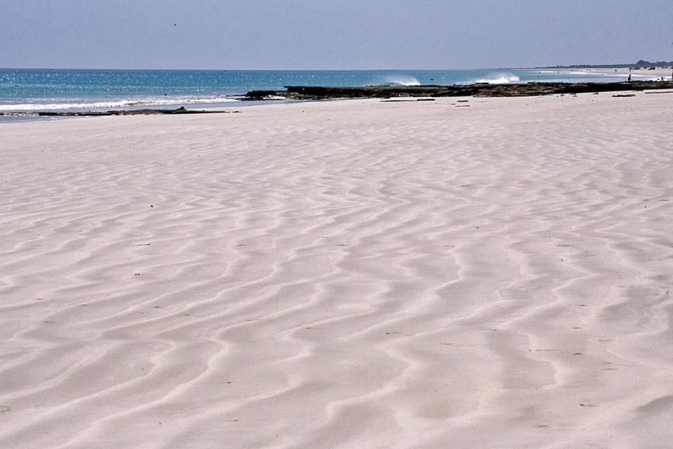
Broome – Pearl-white beach
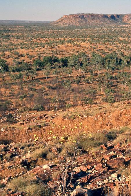
But Broome is also the gateway to the Kimberley. And that is precisely why we are here. The Kimberley is the remote, difficult-to-access region in northwest Australia. With its 421,000 square kilometres, it is roughly the size of Germany and Austria combined. However, it has no more than thirty thousand inhabitants, making it one of the most sparsely populated areas in the world.
Broome is also the gateway to the Kimberley
Aboriginals have felt at home on this red sandstone plateau for over 40,000 years. We owe it some of the oldest and most beautiful examples of their rock art. Freshwater crocodiles also thrive in this monsoon climate, making swimming a bit more exciting. Then there are the vast landscapes of fiery red earth with their otherworldly vegetation, deep gorges with pockets of tropical rainforest and bat colonies, spectacular waterfalls with their idyllic oases in the semi-desert, and the eerie baobabs. In short, it couldn't get more Australian.
The roads that unlock this region are not numerous. The Great Northern Highway – the only paved road in the northwest – seems to avoid the Kimberley like the plague, as it runs in a wide arc around it. If you want to truly penetrate the Kimberley, Gibb River Road is the road to take, an unpaved track of 660 km that runs from west to east right through the area, cutting it into two more or less equal parts. Virtually all other roads connect to it in a fishbone pattern. During the rainy season, it's not advisable, but in the dry season, these unpaved roads – including river crossings – are fairly passable.
The Great Northern Highway – the only paved road in the northwest – seems to avoid the Kimberley like the plague
If you want to explore the Kimberley on your own, it's best to be well-prepared. Because for stranded travellers, the Australian outback is merciless. So, among other things, you need to carry enough water, provisions, and spare fuel on board, two spare tires, preferably some spare parts, and optionally a high-frequency transceiver. With that water, as we read, we quench not only our thirst but perhaps also that of our radiator. If we were to be stranded in a remote corner, we should burn one of those spare tires – first let the air out. The smoke plume will be visible for miles, they assure us. And with that transceiver, we can contact a Royal Flying Doctor Service base if necessary.
A bit exaggerated perhaps, but clearly not our cup of tea. So tonight, we return our 4wd neatly to Broome airport. Tomorrow, we will join a tour group and begin exploring the Kimberley under expert guidance. Curious about the composition of that international group, we retire early to bed.
Wednesday, July 30 | Broome – Imintje
It is quarter to six when John appears in front of the hotel. He will be our driver and guide for the next fourteen days. This is already his sixth tour through the Kimberley this year, and he has three more ahead in the coming months. So, he's quite experienced.
John has a gleaming Isuzu 750 Sitec 220 with him. It's a light truck with 220 horsepower and traction on six wheels. Instead of a regular cargo bed, this model has a spacious and comfortable passenger compartment mounted on the chassis. With this 6WD bush bus, we will explore the Kimberley for the next two weeks.
The concept of SKI is inseparable from the lifestyle of the grey nomads – Spending the Kids Inheritance
We pick up the rest of the group at five different hotels. Through our sleepy eyelashes, we see them one by one climb aboard in the morning darkness, our fellow travellers. There's not much in the way of introductory words for now. Eventually, we'll find out that we are nineteen in total, with seventeen Australians. Over time, we'll come to understand the concept of grey nomads, the affectionate term Australians use for retired compatriots who have elevated eternal travel by bus or, preferably, caravan to a norm. The concept of SKI (Spending the Kids Inheritance) is inseparable from this lifestyle.
Just before seven, we leave misty Broome behind. It will take more than an hour before the sun can overcome the mist. Meanwhile, John communicates with us smoothly from the driver's cabin, verbally through the intercom, and visually through the window. It will be a very long journey today, just under 600 km. Therefore, he will push the pace, especially in the beginning. However, there are still some more enjoyable activities in store for us later.
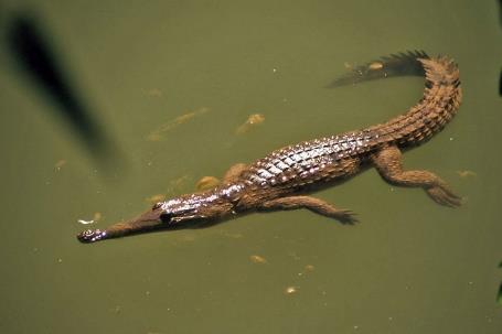
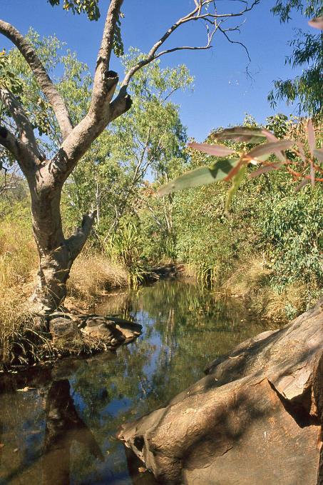
All rivers are dry, as it is the heart of the dry season. However, there is still some water in a few waterholes. John points out our very first crocodile, a freshwater crocodile or freshie. They are not dangerous, unlike the much larger saltwater crocodiles or salties found mainly along the coasts.
Road trains are known for never braking. They simply can't
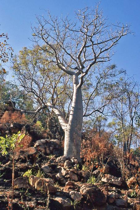
Jilkara is what Aboriginals call the termite mounds that thrive here. They use them to make a remedy for dysentery. Here and there, baobabs appear in the landscape, trees that you would only expect in Africa, especially in Madagascar. It reminds us that Africa and Australia were once part of the supercontinent Gondwana. The boab, as they call it here, is an endemic species. You can only find it in the Kimberley. For Aboriginals, this is the larrkardiya, and they extract vitamin C from it.
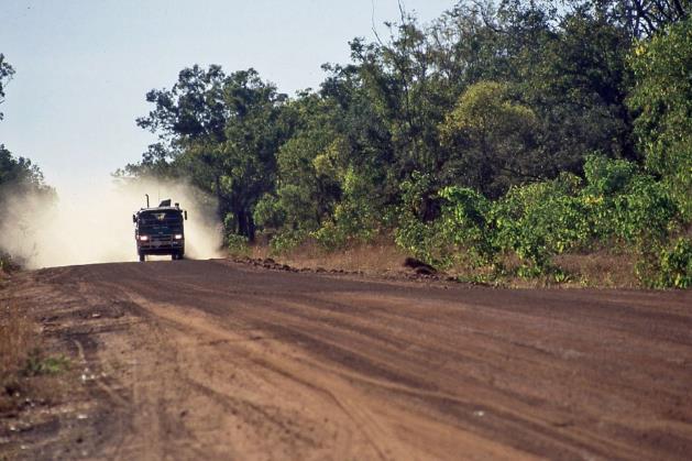
Crossing bridges requires caution, especially long bridges like Willare Bridge over the Fitzroy River. The wide road narrows to a single lane on the bridge. You can't cross paths with oncoming traffic, however rare it may be. This can be dangerous, especially if the oncoming vehicle is a road train. Those infamous giants of over fifty meters are known for never braking. Simply because they can't. With three heavy trailers behind them, the truck would inevitably end up in a catastrophic collision. Therefore, the truck driver will always warn possible oncoming vehicles via the citizens band radio as soon as he approaches a bridge.
Just before nine, we reach Willare Bridge Roadhouse, about 166 km from Broome. We take our first break, have a bite to eat, and let the chickens enjoy our crumbs.
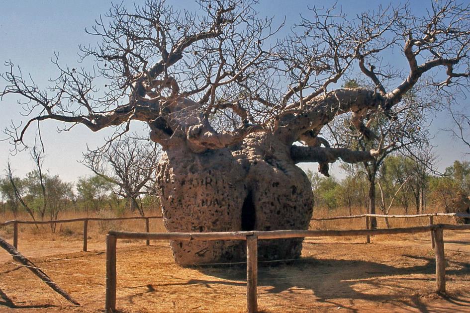
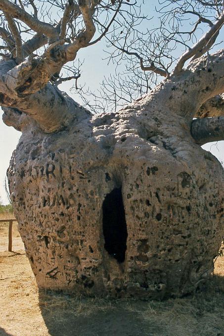
Boab Prison Tree
An hour later, we stand before the Boab Prison Tree. The story of white settlers preferring indigenous people to do the dirty work is one shared by all continents. The use of slavery in this context is also not unique. The so-called blackbirders ventured as far as Fitzroy Crossing and Christmas Creek to kidnap Aboriginals. Chained together with necklaces, they were then transported on foot in day trips ranging from 24 to 48 km to the port city of Derby, covering distances of 250 to 350 km.
Whether Boab Prison Tree, a hollow baobab with a diameter of about 4 m, truly played a role as a temporary residence for captured Aboriginals is uncertain. However, after a white settler was murdered, not only were the blackbirders chasing the Aboriginals, but also the local police officers. Many ended up in the Derby prison, usually accused of killing and eating livestock.
When whites killed a kangaroo, it was called hunting. If Aboriginals killed a sheep, it was called theft
The whites simply had the will and the power to impose their own societal organization. Slowly but surely, the Aboriginals were displaced from their vital waterholes and traditional lands. If whites killed a kangaroo – a crucial food source for Aboriginals – it was called hunting. If Aboriginals took and ate a sheep, it was called theft. For whites, land was private property, while Aboriginals had no fences: My country is the place where I can cut a spear or make a spear-thrower without asking anyone.
Boab Prison Tree |
|
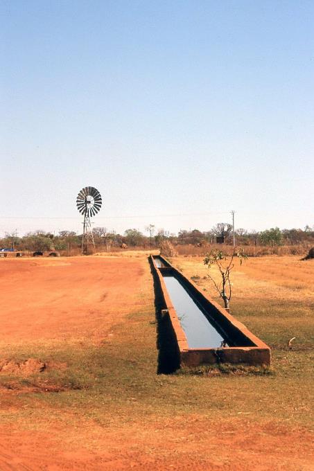
Myalls Bore and Water Trough |
Nearby, the immense water tank still exists, 120 meters long, where, in the past, five hundred cattle could quench their thirst simultaneously. From a depth of about 325 meters, the windmill pumped up the groundwater. The tank is so enormous that you can even recognize it on satellite images.
For a week, we won't encounter any paved roads under the wheels
A bit further, the turnoff to Gibb River Road finally appears. Initially, the road is still paved, but after about three-quarters of an hour, that comes to an end as well. No matter how good the suspension of our bush bus may be, we cannot miss the new context. John informs us, not without a hint of amusement, that for a week, we won't encounter any paved roads under the wheels.
The termite mounds here are so densely packed that the landscape often resembles one large cemetery. Occasionally, a cattle truck crosses our path, headed for the port city of Derby, where the livestock is shipped alive to Indonesia.
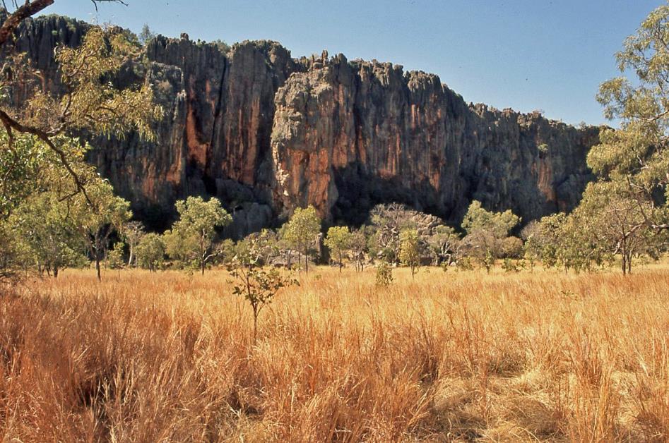
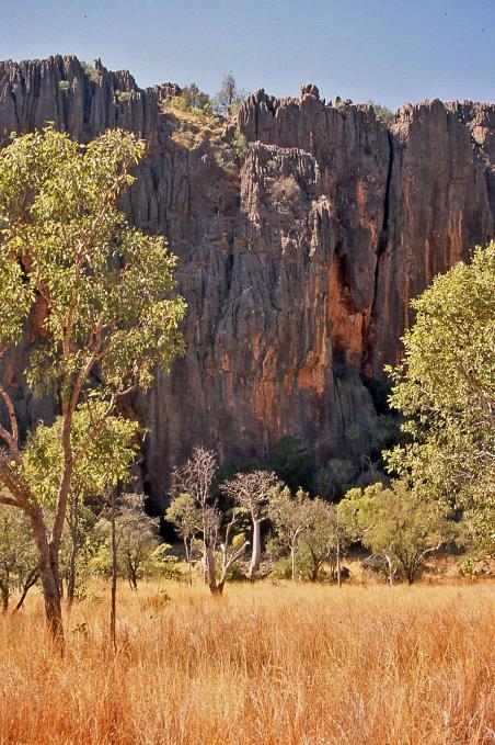
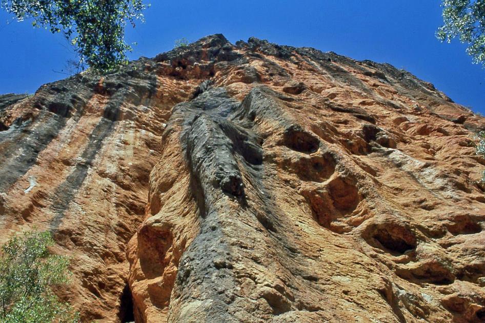
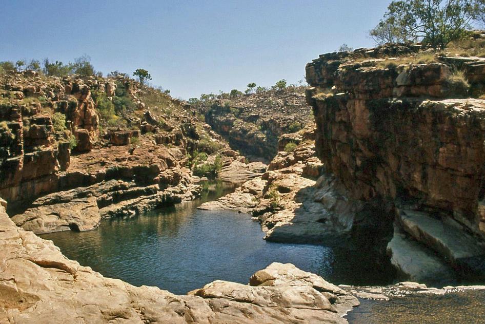
The walls of Napier Range rise almost perpendicular from the tree-covered savannah. It must have been a massive coral reef
It's almost twelve o'clock when John finally starts to act on his second promise. Where Lennard River crosses the road, he turns right and follows Fairfield Leopold Downs Road southward. In this landscape, apparently, a different kind of termites resides, as their mounds closely resemble stacked reddish-brown rocks.
The walls of Napier Range rise almost perpendicular from the tree-covered savannah. It must have been a massive coral reef about 340 to 360 million years ago when it formed on the bottom of a shallow sea. Coral polyps tirelessly built it for an estimated fifty million years. Likely, the massif extended in a wide arc around the current Kimberley region, all the way to Kununurra, six hundred kilometres away. At both ends of this enormous sickle, the hundred-meter-high remnants of the reef still dominate the landscape.
The myth of the baby spirits in the water reminds us of the concept that all life origiates from nature
Napier Range |
|
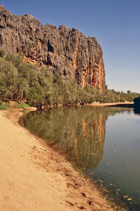
Windjana Gorge – Lennard River |
Through this coral massif, Lennard River has carved a gorge over time, the 3.5 km long Windjana Gorge. For us, this will be the stage for our first short trek. John doesn't rule out encountering crocodiles along the way. Initially, however, we have to settle for a handful of barramundi, perch-like fish known for their hermaphroditic nature. They are born as males, but after their first mating season, they transform into females.
More enjoyable are the striped fish with yellow tails, the so-called archerfish. With a powerful jet of water from their mouths, they can shoot down an insect hovering just above the water surface up to three meters away. Their eyes are specially adapted to account for the light refraction at the water surface. However, they don't grant us a demonstration of their skills today.
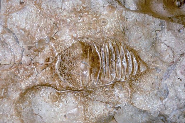
Fossil of a nautilus shell |
|
Freshwater crocodiles (‘freshies’) |
In the rock wall, John points out the fossil of a nautilus shell, approximately 20 cm long. Once, there were about twelve hundred species of nautiluses, but today only one species remains, the Nautilus pompilius. As a true cephalopod, the nautilus has tentacles, but unlike other squids, it lacks suckers and instead possesses a shell.
A bit further, the towering Bandingarots dominates the gorge in the middle of the river. It can be guessed that such a colossal rock plays a significant role in the mythology of the local Banuba people. In the water around this rock, baby spirits reside. A person who consumes a fish, turtle, or crocodile from this water immediately takes in one of these baby spirits. In a dream, this baby spirit will pass from the man to the woman during the night. The myth reminds us of the concept that all life originates from nature.
Never thought that the proximity of about fifty freshwater crocodiles would reassure us
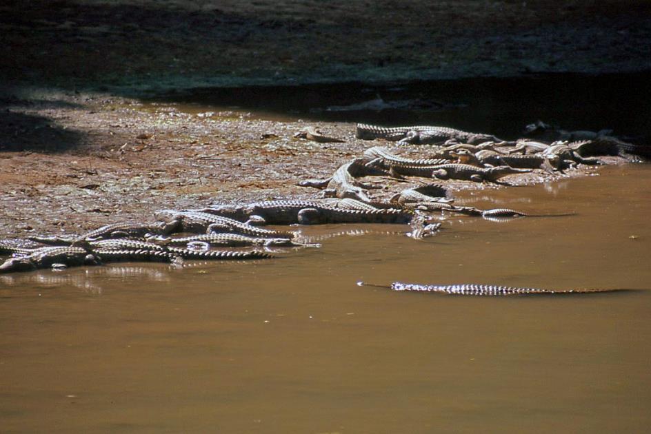
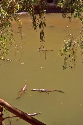
Baby spirits are not visible here for now, but freshwater crocodiles are abundant. Dozens of them lie motionless in the river and on the shore, basking in the sun. A nice place for a picnic, indeed. Right in the middle between two extensive crocodile families, we settle down with our food containers in the sand.
Freshwater crocodile |
|
|
John doesn't miss the opportunity to mention that crocodiles are the largest and oldest living reptiles in the world. While a freshwater crocodile, or freshie, typically reaches a length of about three meters, a saltwater crocodile, or salty, can easily grow up to seven meters. Salties prefer tropical tidal waters but can also be found at sea or even in rivers. Freshies, on the other hand, prefer freshwater rivers and lakes. Freshies are not generally interested in human flesh, but salties are. Since freshies never stay close to salties, John assures us that we are relatively safe here. Never thought that the proximity of about fifty freshwater crocodiles would reassure us.
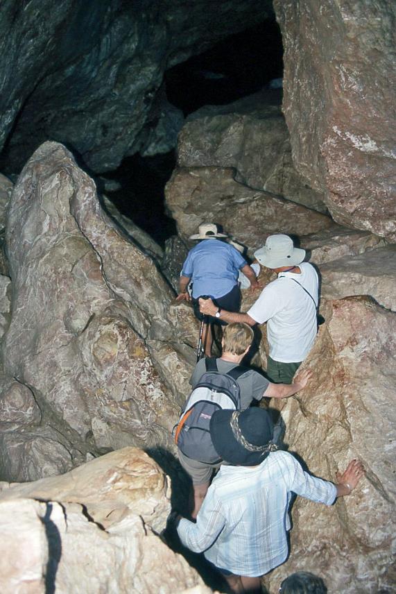
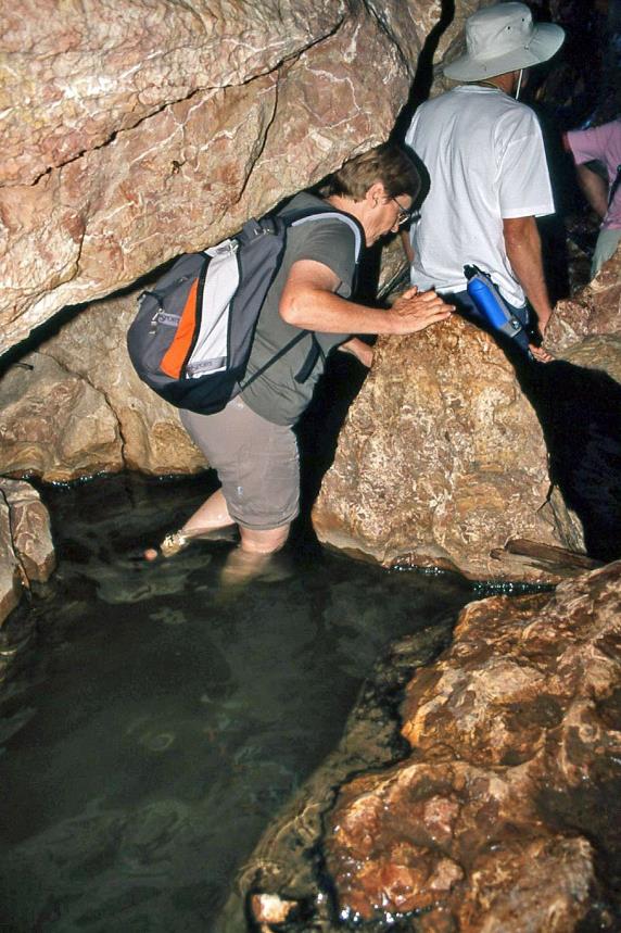
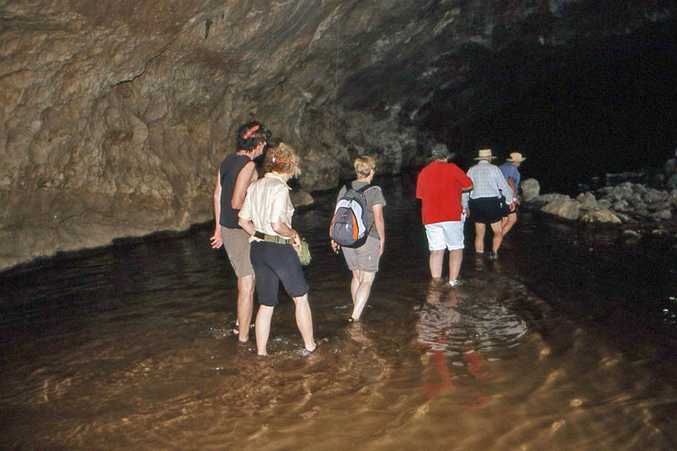
But John has more adventure in store for us. We set course for Tunnel Creek, an inconspicuous river about forty kilometres southward. Modest as it may be, Tunnel Creek has managed to carve a tunnel approximately 1.7 km through Napier Range. John intends to explore it with us all the way to the end.
Equipped with flashlights and appropriate footwear, we climb over rocks to the entrance of the cave. Wading knee-deep through the cold water, we explore the walls and ceiling with our flashlights. At this moment, the water level is relatively low, and some sandbanks are exposed. However, during the rainy season, it's best to stay away from here.
At this moment, the water level is relatively low. However, during the rainy season, it's best to stay away from here
Tunnel Creek |
|
|
In the crystal-clear river water, tiny white catfish swim in the beam of our flashlights. They are completely blind, as their entire lives unfold in absolute darkness – excluding the teasing presence of tourists with flashlights.
Tunnel Creek
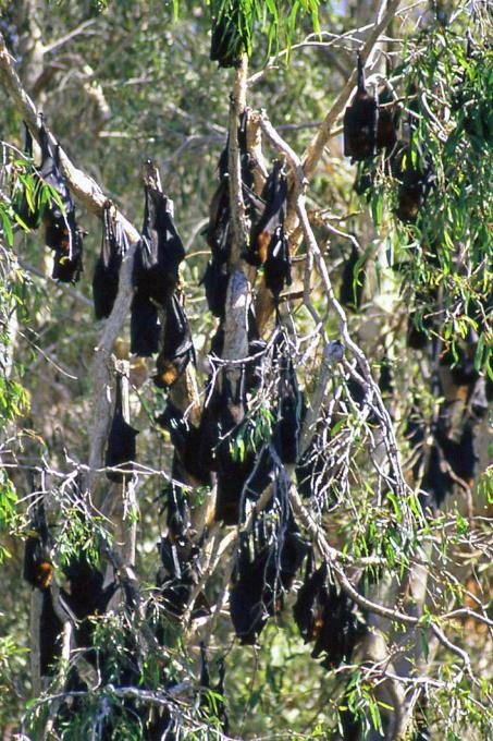
Dozens of flying foxes hang from the stalactites on the ceiling. But it's our noses that first notice their presence, not our eyes. These are large bats, named for their heads resembling those of dogs or foxes. Our Australian travel companions also call them fruit bats because they exclusively feed on fruit. This means they don't use echolocation, as they don't need to hunt like regular bats. Just picking fruit from trees suffices for their daily meals, as the fruit doesn't move.
What appears to be the other end of the cave from some distance turns out to be nothing more than an ancient collapse through which you can see the blue sky. We climb over the debris and wade further towards the end of the tunnel.
Apparently, there are no crocodiles in the tunnel today, John remarks as we start the return journey. The undertone of regret in his voice doesn't escape us. However, nature has something better in store for us. The cave has only one exit, and right there, a snake has taken up position. With a length of only one and a half meters, it doesn't instil excessive fear. But John knows better. This is a mulga, a king brown snake, highly ranked in Australia's list of venomous snakes. It shouldn't be a problem. You just need to leave her alone, keep a sufficient distance, and certainly not block her path or corner her.
The mulga blocks our only, rather narrow exit from the cave
So much for the theory. In practice, this snake blocks our only, rather narrow exit from the cave. Something tells us that she won't find the passage of nineteen nervous tourists particularly calming. John remains calm and improvises an alternative route, involving a little climb higher up over the rocks. While the reptile calmly explores the surroundings with its split tongue, we crawl on hands and knees over the rocks to the open air. Once in safety, a quick count at the parking lot confirms that everyone has survived. To celebrate, John brings out coffee, tea, and folding chairs – his bush bus is full of surprises.
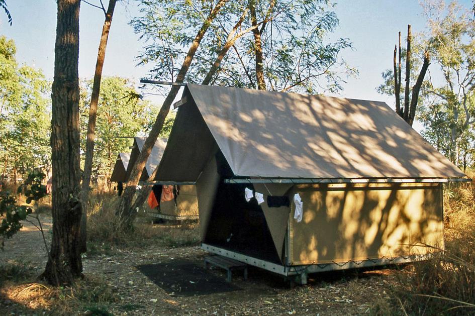
It's almost half past four when we embark on the last part of our first day trip. Three-quarters of an hour later, we reach the unsealed Gibb River Road again. The route now takes us further east through the King Leopold Ranges, a mountain range that Napier Range is also part of. For now, we don't see much of it because it's completely dark. Just before Saddlers Springs, an inconspicuous river, John abruptly turns right. A few minutes later, we set foot in Bell Gorge Wilderness Camp, a permanent tent camp in the heart of Ngarinyin Land, an area managed by the local Aboriginals. It will be our base for the next two days.
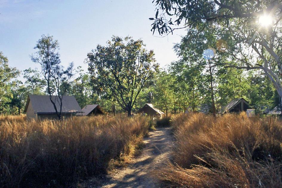
Bell Gorge Wilderness Camp
Under the trees on the riverbank, twenty-four tents are hidden in the tall savannah grass. An assertive duo – Debbie and Lara – is ready to overwhelm us with guidelines. After all, novices like us cannot be set loose on a tent camp in the Australian bush without instructions.
Starting with the most basic aspect, we are informed that from now on, we don't go to the toilet; we go to the rota-loo. This turns out to be a sophisticated composting toilet, where our waste is transformed into compost without the use of water or chemicals. This process is further accelerated by passing hot air through the collection basin. Indeed, at this high ambient temperature, it is not difficult to capture some solar heat in a layer of air between two glass plates. We no longer need to feel guilty about what we leave behind.
For spiders and snakes, that is an insurmountable barrier, we are convinced
Showering is also subject to rules. Water is precious, and there are only four communal showers. So, four minutes is the maximum per person. Using personal soap and shampoo is strictly forbidden; only the ever-present biodegradable variants are allowed.
Guided by the light of flashlights, Debbie and Lara lead us to the tents. Powder extinguishers hang near some trees. With these, we can extinguish small fires before they turn into uncontrollable bushfires.
Bell Gorge Wilderness Camp
The dinner begins with an aperitif around the campfire. Without alcohol, as it is not available here, although wine is served with the meal. After dinner, people gather around the campfire for a cosy chat. It doesn't last long, as we will learn in the future, because the staff knows how to time the extinguishing of the campfire perfectly.
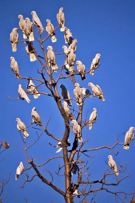
Our tent doesn't have a number, but it has a name – Corella. This refers to a pale cockatoo endemic to Australia. The beds are placed on a wooden floor, about twenty centimetres above the ground. For spiders and snakes, that is an insurmountable barrier, we are convinced. Before nine o'clock, all human activity in the camp has ceased.
Thursday, July 31 | Imintji
It is half past five when the first birds start chirping. Half an hour later, the sun appears above the horizon. It hasn't been really cold during the night.
Imintji has a staff of eight. Their work shift lasts three weeks, and then they have one week off. So, there are always six staff members present, mainly busy during breakfast and dinner. Our breakfast buffet is ready, and shortly afterward, our lunches appear on the table. We gather our portions in convenient insulated boxes. The tetra packs with fruit juice are frozen, serving as cool packs.
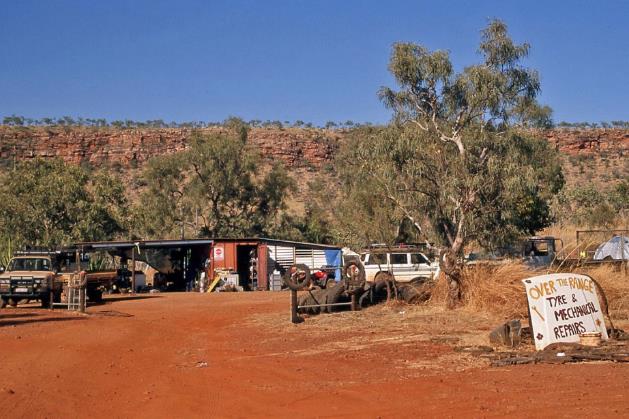
Imintji Store – Over the Range |
|
|
Today's agenda includes a trip to the Bell Creek waterfalls. Just before half-past eight, our bush bus starts moving, but not for long, as a refuelling stop is more than welcome after yesterday's journey. The nearby Imintji Store offers limited supplies. Right next door is Over the Range, where they will help you with tires and mechanical repairs. In that garage, it turns out that a young Dutch couple has been working for several months. They like Australia. We are seriously considering emigrating, explains the young man with a roll of toilet paper in hand. We are deprived of further explanation, as he hurries into the bush. That toilet paper must have something to do with it.
Corellas (cockatoos) |
|
|
With a full tank of gas, we follow Gibb River Road a bit back westward. Then, we head north via Silent Grove to Bell Gorge, not even 40 km away from Imintji, amidst the King Leopold Ranges.
We find it a strange name for a mountain range in Australia because we are not aware of any British King Leopold. That's correct, admits John, but it's not a British king being referred to here; it's a Belgian one. It can only be Leopold II, we suspect, as the merits John mentions – the promotion of art and exploration – we can associate with no other Belgian monarch. Has Australia overlooked the fact that Leopold II's image began to suffer significant blows even during his lifetime?
Has Australia overlooked the fact that Leopold II's image began to suffer significant blows even during his lifetime?
Not at all, suggests fellow traveller Forbes, a corporate lawyer from Sydney. Earlier this year [2008], voices were raised in Australia to no longer name this mountain range after the Belgian king with the questionable reputation. Nevertheless, it will take until July 1, 2020, before the range gets its new name, Wunaamin Miliwundi Ranges.
In any case, it is a very old mountain range, estimated to be 560 million years old. While the softer siltstone in the wider area gradually succumbed to erosion, these hard layers of pink and white quartzite could resist effortlessly. Nowadays, the highest peaks reach just under a thousand meters. When the coral reef of Napier Range was being formed, there was probably a coastline at the foot of this mountain range.
Knee-high bushes of spinifex dominate this landscape. It is a tough grass species with prickly points, even herbivores steer clear of it. However, for termites, spinifex is the main food source. They must be one of the only creatures on this planet capable of digesting it.
Termites must be one of the only creatures on this planet capable of digesting it
Bell River |
|
|
Mammals are rarely seen in this environment, John informs us. Among the typical species are the Northern brown bandicoots. They can reach sizes of 30 to 50 cm and are particularly known for their extremely short gestation period. It takes only about 12½ days for the naked, underdeveloped offspring to emerge and crawl into the mother's pouch, where they will nest for another sixty days.
It's not the presence of a pouch in females that characterizes marsupials; rather, it's the fact that marsupial females have two uteri
You might also encounter the quoll or marsupial cat here in principle. Although the females don't have a pouch, quolls are classified among marsupials. After birth, the young ones nestle in the shallow skin folds around the mother's nipples. It's not the presence of a pouch in females that characterizes marsupials; rather, it's the fact that marsupial females have two uteri. Some marsupials, like the swamp wallaby, manage to become pregnant again before the previous young is born.
However, we shouldn't hold out much hope of spotting these fascinating marsupials, as they are only active at night. We have a bit more chance of observing a snake-necked turtle or a water monitor during the day in the water.
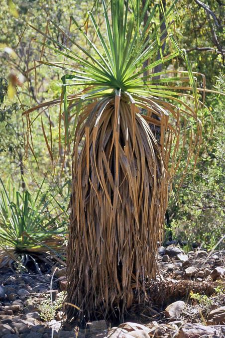
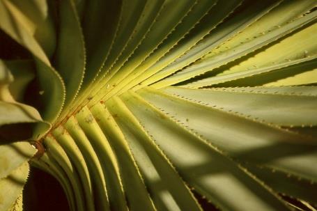
Sand palm |
|
Bell River |
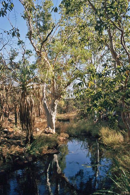
Where the sandy track ends in a loop, we leave our bush bus behind and continue our journey on foot. It's only about two kilometres to Bell Gorge. In the welcome shade of pandanus and sand palms, we descend through the rocky bed of a dried-up river to the waterfalls. The presence of papyrus reeds indicates that, even in this extremely dry environment, there is enough water periodically.
John plucks a green termite from the tree and eagerly sinks his teeth into the wriggling green abdomen
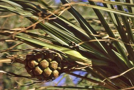
Pandanus |
|
Fruit of pandanus |
Green ants run briskly up and down a tree trunk. They build their nest by folding large leaves from the tree. Their abdomen contains vitamin C and tastes like lemon, according to John. He doesn't let the opportunity slip, plucks one from the tree, and eagerly sinks his teeth into the wriggling green abdomen.
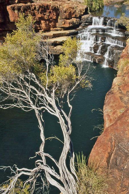
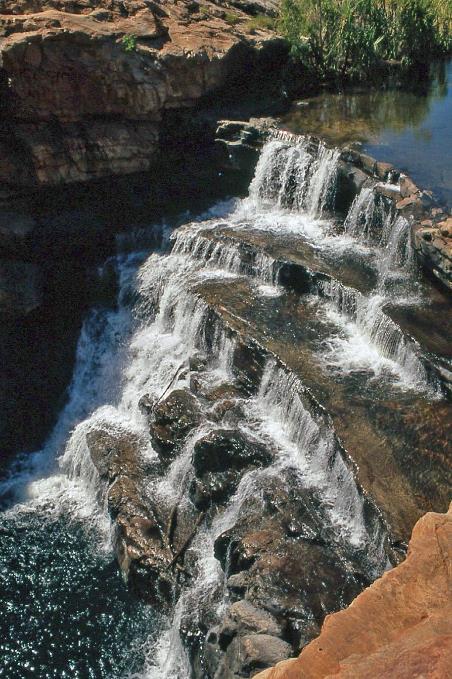
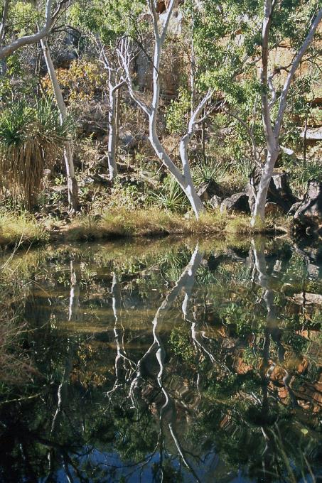
Bell Gorge
After a walk of more than half an hour, we reach Upper Falls on the banks of Bell Creek. From the cliff, we look down into the impressive, almost circular gorge – a spectacular oasis in the midst of the arid landscape. A bit further downstream, we spot Lower Falls. A handful of swimmers below enjoy the pleasures of the water. Apparently, that's the place to be.
From the cliff, we look down into the impressive, almost circular gorge – a spectacular oasis in the midst of the arid landscape
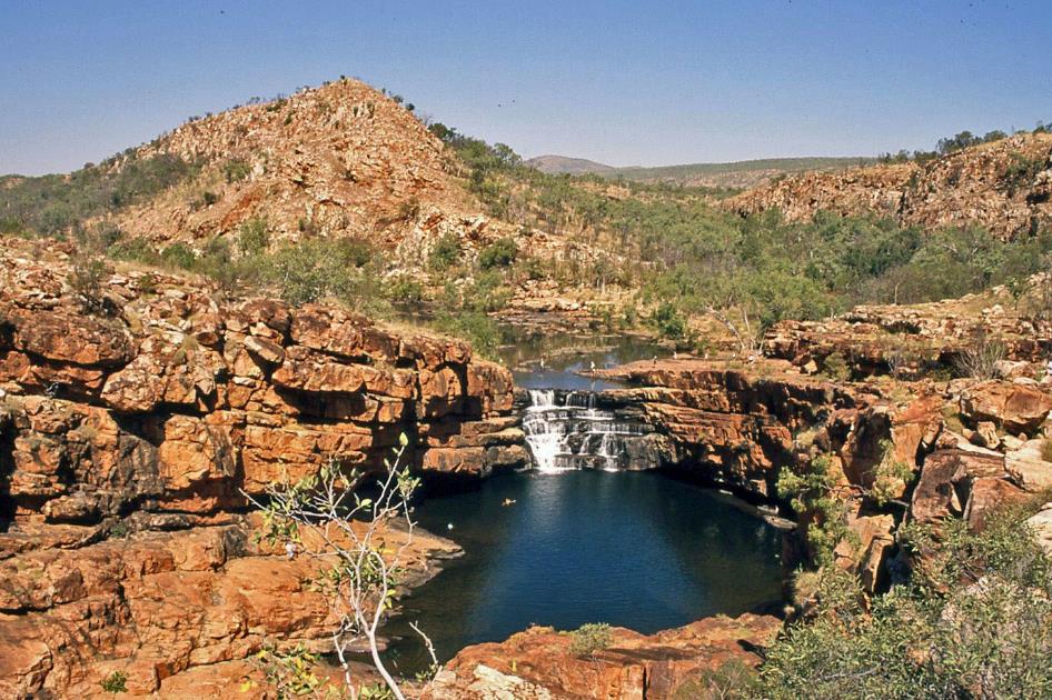
Reaching that spot, however, is not a walk in the park. Crossing the shallow river seems like a breeze but is anything but. Underwater, the rocks are completely covered with algae, making them incredibly slippery. Still, with John's brave assistance, all candidates safely reach the other side. In a wide arc, we trek over the hill and climb down between the rocks. We swim in the quite cold water. Even getting into the water turns out to be a precarious venture on the slippery rock bottom.
Bell Gorge |
|
|
Meanwhile, high in the blue sky, the sun is working hard to raise the mercury above 30 °C (86 °F) again. In the shade of an overhanging rock, we devour our packed lunches. Our improvised cool packs work so well that the fruit juice isn't even completely thawed.
At one o'clock, we begin the return journey through the dried-up river, and an hour later, we are at the parking lot of Silent Grove at the park entrance. Time for a tea break, John decides, and he comes up with coffee, tea, and folding chairs. This rhythm seems a bit too leisurely to us, but after yesterday's long drive, we deserve a relaxed day, he insists.
|
|
|
We take advantage of the opportunity to trek a bit upstream through the bushes along Bell Creek. Some giants of spiders have spun their webs above the river and are now patiently waiting for unsuspecting prey.
Precipice Range |
|
Baobab |
Before returning to our camp in Imintji, John has an extra treat for us. Last night, in the darkness, we completely missed the magnificent scenery of the King Leopold Ranges. Today, John makes up for it by continuing along Gibb River Road further west. From the elevation, we overlook the plain and Precipice Range, a table mountain that is part of the King Leopold Ranges.
Since the traffic on Gibb River Road can't really be called busy, the operators of Imintji Store don't really have much to do. The turnover generated by the local Aboriginal community is also not significant. Therefore, it's not surprising that John drops us off briefly at the doorstep of the store on the way back. The local merchant can surely benefit when a group like ours crosses his path.
Friday, August 1 | Imintje – Drysdale River
We hit the road again before half-past seven. Gibb River Road has now definitively turned northeast. It's strange to note that this arid area becomes almost impassable during the rainy season – roughly from November to March. Even experienced settlers were misled by this inhospitable land. It sometimes happened that a farmer had to move his homestead – the place where he built his house – more than once because the location he carefully chose during the dry season would flood in the rainy season.
Valleys and waterholes like these have been created by giant snakes
Galvans Gorge |
|
|
A notable number of cows graze along the road. Presumably, they are gathered in this area before being transported – first by cattle truck to Derby and then by boat to Indonesia. These animals probably have never seen a vehicle before they were driven here.
Galvans Gorge
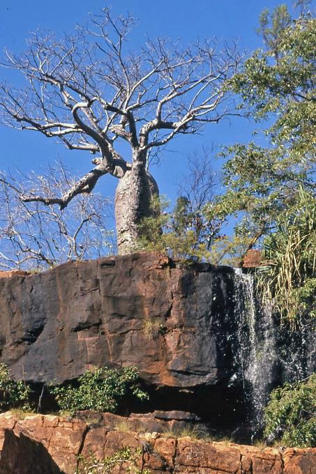
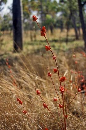
A comfortable stroll through a valley with pandanus trees, eucalyptus, baobabs, and vibrant red hibiscus-like roselle plants leads us to the base of Galvans Gorge. Above a cascade of two waterfalls, a baobab tree perches on the cliff's edge, providing a picturesque contrast against the blue sky. A certain Forrest claimed the discovery of this idyllic spot in 1848.
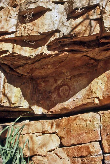
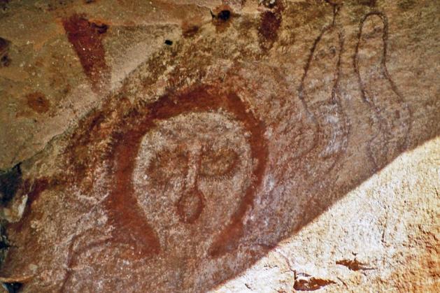
However, this ‘discovery’ should be put into perspective because the Aboriginal people, as indicated by drawings on the rock wall, had known this place for thousands of years. A Wandjina, a kind of weather god, is depicted in brown and white colours. These rock paintings are associated with dramatic climate changes. They are likely to date from 1,500 to 600 years ago, while before that, from about 15,000 to 2,000 years ago, it must have been very dry here, much drier than it is now.
Baobab |
|
Wandjina |
||
Wandjina |
|
Roselle |
||
The first Aboriginals likely arrived in Australia from Southeast Asia around 65,000 years ago. During the prevailing ice age, the sea level was about one hundred and fifty meters lower than today, facilitating the crossing through the dry sea passages of the Indonesian archipelago. Archaeological findings in the Kimberley region suggest that Aboriginals have been active in this area for at least 50,000 years.
Like all peoples on Earth, the Aboriginals have sought to capture the mystery of life and nature in myths. These symbolic stories are known as the Dreamtime. They are the product of oral tradition, as the Aboriginals do not have a holy book. Nature is their bible, and you can directly read the events of the Dreamtime from it. Many places in the landscape – hills, gorges, caves, rivers, oases, water sources – are sacred because a story from the Dreamtime unfolded there. The beings involved in these stories still live there as spirits. Therefore, such places must be approached with respect. Galvans Gorge, where we currently stand, is one of these sacred places, created by giant serpents, which are believed to still inhabit the area.
The Aboriginals do not have a holy book. Nature is their bible, and you can directly read the events of the Dreamtime from it
Bee nests, barely the size of a child's fist, hang against the rock wall. Despite their innocent appearance, it's best not to touch them, not even accidentally. These bees target the head and especially the eyes of anyone who threatens them.
On the way to Barnett River Gorge |
|
Flying foxes |
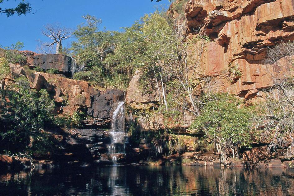
We briefly stop at the windy Mount Barnett Roadhouse near the Aboriginal community of Kupungarri. A little over half an hour later, we reach the turnoff to Barnett River Gorge. It takes John almost twenty minutes to navigate the rough three-kilometre track to where the river has created a picturesque green oasis in the harsh wilderness. With a radiant sun in the blue sky, cool water among the green reeds, a cascading waterfall, a rock in the middle of the river, and thousands of flying foxes overhead, it's the perfect setting for a refreshing swim.
Barnett River Gorge
Around one o'clock, we arrive at Gibb River Station, owned by the neighbouring Aboriginal community of Ngallangunda. John and Linda are in charge of managing the station. They've been working here with and for the Aboriginals for three years, but it's not easy, sighs Linda. Aboriginals, rooted in their ancient culture and way of life, have never felt any need to look ahead or plan. They only work when there's an urgent need, such as requiring food. Terms like preventive and proactive will be sought in vain in an Aboriginal dictionary, says Linda. Planning, maintenance, or repairs are equally foreign to them. If something breaks, it's left to its fate.
Nature makes it damn hard to turn Gibb River Station into a profitable enterprise
Moreover, nature makes it damn hard to turn Gibb River Station into a profitable enterprise. The cattle they raise here are only suitable for shipment to Indonesia – via Broome or Darwin. That transport quickly costs 80 to 90 euros per animal. For safety reasons, cows with horns are not allowed on the boats. So, all those horns have to be sawed off first. Since not all animals survive this operation and they don't want carcasses on board during the crossing, the amputated animals must spend four weeks in quarantine at the port. Only then are they allowed to board for a one-way trip to Indonesia. All of this significantly raises the costs.
Finally, add to that the poorly chosen location of the station and the village, as during the rainy season, the groundwater is very high. Since the introduction of Catholicism by the whites forty years ago, deceased Aboriginals are also buried here. But this must be done with due speed because if the grave is not quickly filled, the coffin will soon float to the surface.
Gibb River Road now takes us northward. An Australian bustard runs through the low grass, slightly startled by our bush bus. Although these ground-dwelling birds can fly, they usually forage for food on the ground. Once, the Australian open plains were full of them, but the arrival of Europeans has not been kind to these bustards, especially in the southeast. This is partly due to hunting, partly due to the introduction of foxes, and partly due to the destruction of their natural habitat. But here in the northwest, they seem to be holding up well.
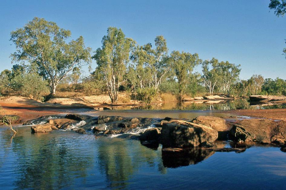
Gibb River Crossing
Gibb River Road now makes a sharp eastward turn, but we keep our gaze to the north and continue our journey via Kalumburu Road. The difference is immediately noticeable; one unpaved road is clearly not the same as another. The fact that John mentions that the road to Mitchell Plateau will be even worse from tomorrow is anything but reassuring. We won't be able to welcome the relative comfort of Gibb River Road again until next Tuesday.
The fact that the road to Mitchell Plateau will be even worse from tomorrow is anything but reassuring
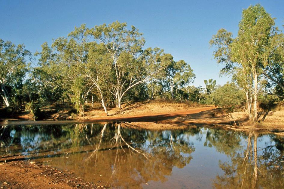
Later on, we cross the river that gives Gibb River Road its name. We briefly explore the surroundings of the fordable spot. Eventually, we reach Drysdale River Station, a place that tries to maintain a bit of civilization in the midst of the bush. It is the last place where you can stock up on food and fuel. Further north along Kalumburu Road, there are no facilities at all.
|
|
Drysdale River Station – |
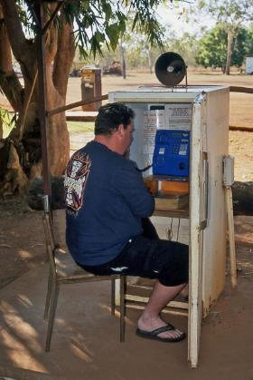
An abandoned refrigerator under a shady tree has been recycled as a telephone booth. Once you're done with your call, be sure not to forget to close the door of the refrigerator – to keep out the intrusive dust."
Jaak Palmans
© 2024 | Version 2024-01-22 15:00
Continue reading in (2/3)
No civilization has ever achieved that