Jeepable only
India | Anno 1995
Saturday, July 22 | Manali – Kaza
Friday, Juli 21 | Manali
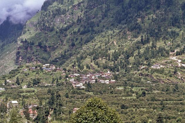
Old Manali |
|
|
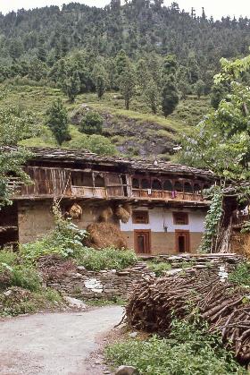
Old Manali lives up to its name, as it turns out. The houses bear witness to a rural simplicity that we feel compelled to associate with a distant past. These must have been imposing structures at some point, these typical farms constructed partly in stone and partly in wood. Laundry hangs to dry on the overhanging wooden balconies, hay bales are stacked next to the front door, farm animals roam the courtyard, and humans and animals share the same living environment.
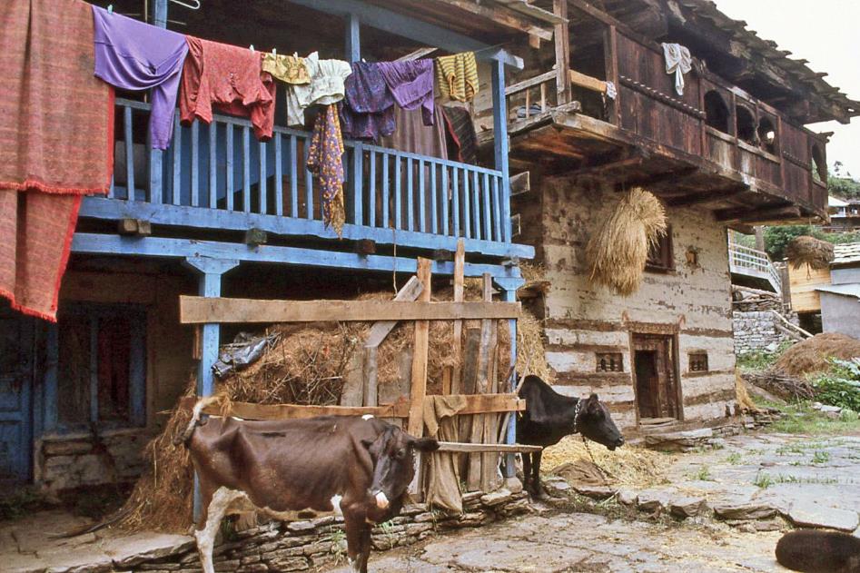
Old Manali – Farm
Inevitably, the question arises of where the charm of the picturesque ends and the poignancy of poverty and hardship begins. Yet, you won't notice that on these people. Our presence is consistently greeted with a friendly smile. Children observe us with a healthy mix of shyness and curiosity.
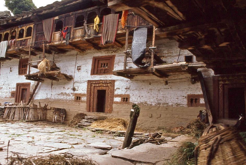
Old Manali – Farm
We had already seen the pagoda-like tower of the Manu Temple from a distance. Old Manali is situated on a slope above the modern part of the city. We had never heard of Manusmriti, the man to whom this temple is dedicated. That doesn't speak well of us because it's the man who, single-handedly, saved humanity from extinction. Legend has it that Manali is the place where Manu left his ark to give humanity a fresh start after a great flood had destroyed all life on earth. Ah, where have we heard that before.

|
|
|
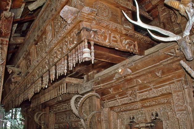
Less conspicuous is the Hidimba Devi Temple, hidden in a forest of cedar trees. Even with its four stories, it doesn't reach the crowns of those giants.
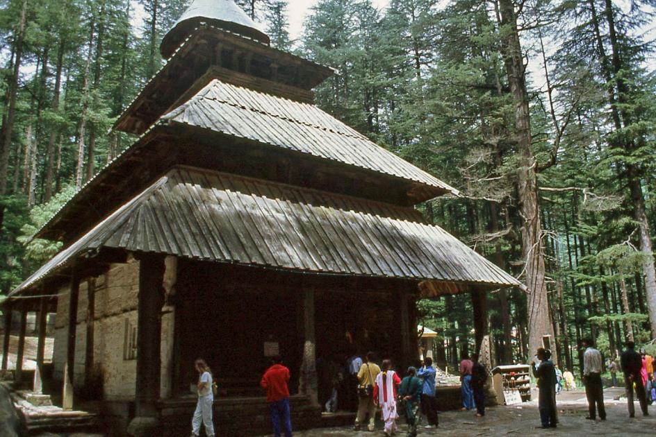
Wooden temple of Hidimba Devi
The temple is still immensely popular. Pilgrims come from far and wide to worship Hidimba Devi, who is said to have meditated on the rocks around which the temple is built. She derives her divine status from the fact that she was briefly married to one of the five Pandava brothers, the good guys in the famous Mahabharata epic. Just long enough to bear him a son.
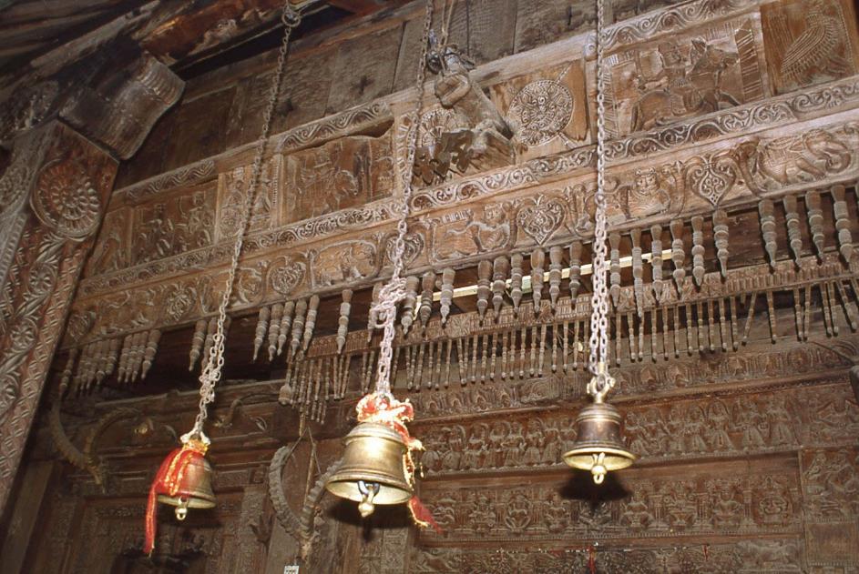
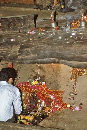
Upon arrival, each pilgrim rings the bell to attract Kali's attention
Inside, we find three small statues, the goddess Kali flanked on either side by a copper image of Hidimba. By Hindu standards, this is a relatively young sanctuary. It was built in 1553 by a local Maharaja. However, what makes it special is that, apart from the foundation, the temple is entirely made of wood. This in a country that has been building stone temples for over fifteen hundred years. The astonishing woodcarvings have withstood the test of time. Gods and temple dancers, animals, and plants are depicted realistically. Equally lifelike are the complete skulls of goats, buffaloes, and antelopes. They remind us of the animal sacrifices that were once made here.
Woodcarving |
|
Goddess Kali between two statues of Hidimba |
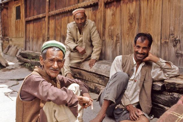
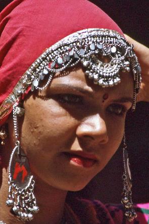
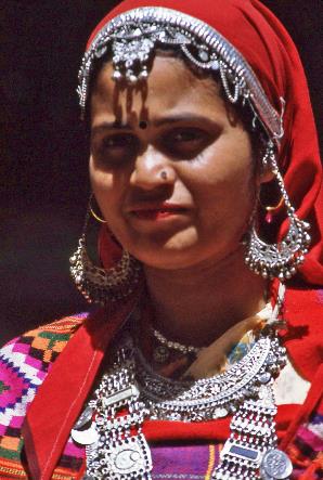
Outside, women are selling various items, as is common in pilgrimage sites around the world. This is a stroke of luck for us because now we can admire in detail one of the typical costumes of Himachal Pradesh, the mountain state where we currently find ourselves.
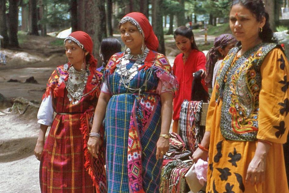
What stands out the most are the colourful fabrics and the many beautiful metal jewels – the shangli worn as a necklace around their necks, the earrings in the shape of a fig leaf, the chiri tikka that emerges from under their red headscarf indicating their marital status. And, of course, draped over their shoulders, they wear a multicoloured kullu shawl with intricate geometric patterns.

The shangli around their necks, the earrings in the shape of a fig leaf, the chiri tikka on their foreheads, the kullu shawl over their shoulders
Married woman with chiri tikka on the forehead |
|
Unmarried girl |
|
Married woman with chiri tikka and shangli necklace around the neck |
A day of rest, that's what you could call our stay in Manali. The sun was shining this morning, and it stayed that way all day. Hopefully, it will be the same tomorrow. Because then the serious work begins.
Saturday, July 22 | Manali – Kaza
Colonel Pardhan is a remarkable character, not least because he always wears a knitted hat under his inseparable hat, as we learned during our brief introduction last night. But gradually, we will hold him in high regard. He is invaluable, with his truck in which he transports our luggage, kitchen equipment, and supplies. Day in and day out, he and his team will prepare the campsite and provide us with excellent food in the most diverse circumstances.
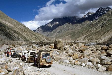
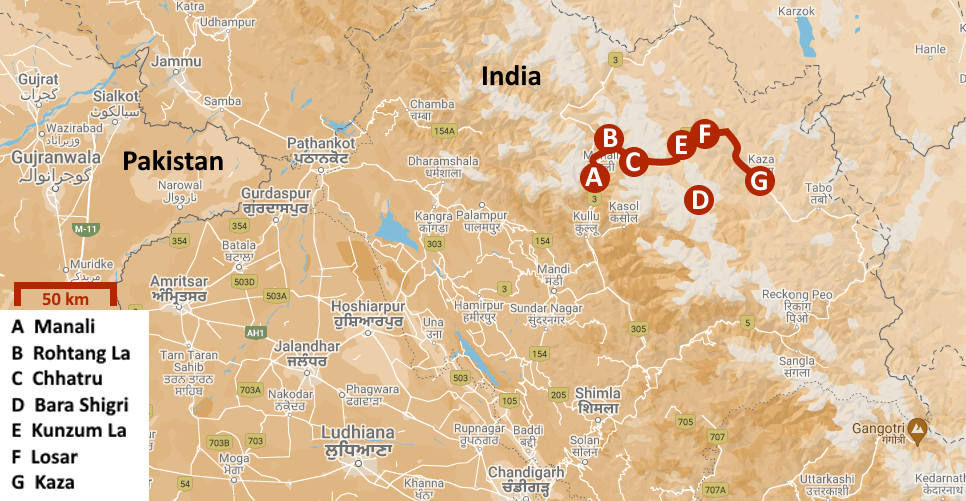
An astonishing route of nearly five hundred kilometres, at times paved and at times not, across about five mountain passes ranging from four to five thousand meters in height
Upon waking up, it turns out that the colonel has been on the road for hours already. In the dead of night, he left Manali, just to be prepared for anything. We, on the other hand, set off with our convoy of five jeeps only at half-past seven. Leh, the capital of Ladakh, is our final destination.
However, along the way, we will allow ourselves an extra treat: a round trip to the Spiti Valley. We have set our sights on that. Only two years ago, this enigmatic valley was opened to foreigners. What makes the valley so special is the presence of one of the oldest Buddhist monasteries in the world, the Tabo Monastery. It will be our first authentic encounter with Tibetan Buddhism. Not for nothing does Spiti mean the land in the middle – the land between Hindu India and Buddhist Tibet.
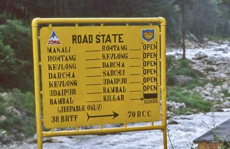
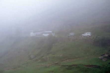
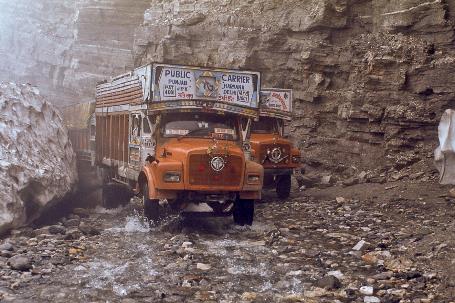
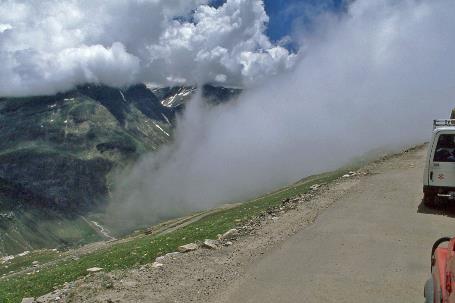
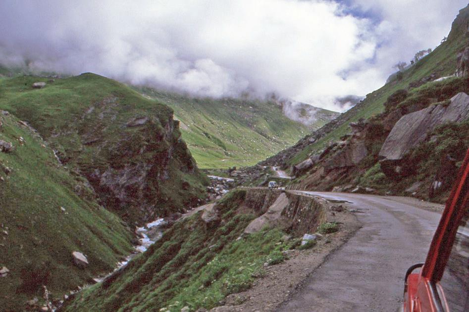
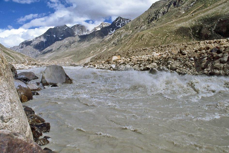
It's lightly raining. For now, it doesn't bother us; we're making good progress on the asphalt road. About ten kilometres north of Manali, we reach the end of the Beas Valley and consequently, the end of the inhabited world. Our first ascent is imminent. Almost all mountain passes are open to traffic, as we read on the yellow sign providing information about the road conditions. Jeepable only.
Almost all mountain passes are open to traffic. Jeepable only
Leh-Manali Highway |
|
Morning mist |
Although this is not to be interpreted too broadly. "Jeepable only," the same sign adds for completeness. So, jeeps and trucks are okay, but it's better not to attempt it with something like a Toyota Corolla. What everyone conveniently calls the Leh-Manali Highway is an astonishing route of almost five hundred kilometres, sometimes paved and sometimes not, over about five mountain passes ranging from four to five thousand meters in height. Mists sometimes hinder visibility. Landslides, mudslides, and road collapses are common. Wild mountain rivers repeatedly turn the road into a slippery stone path. Not to mention the blood-curdling cliffs without guardrails and the altitude sickness that can quickly affect you. Excluding the two-day detour to the Spiti Valley, this highway will be our habitat for three days.
The last trees disappear from our field of view. Gradually, the mists engulf us
It's the BRO, the Border Roads Organisation, a branch of the Indian army, that constructs and maintains these roads. The strategic importance cannot be overstated. The Leh-Manali Highway leads directly to the border area between India and China, where tensions can arise, given the differing opinions on the exact border location. In case of trouble, India needs to mobilize troops quickly. Reportedly, the road can even accommodate the heaviest military vehicles.
Ascent of Rohtang La
Meanwhile, our jeeps have begun the ascent of Rohtang La, our first mountain pass. With its four thousand meters, this is the smallest of the passes that await us. Yet, it was only opened to traffic about three weeks ago, on June 29.
Through a series of hairpin bends, we climb steeply against the Pir Panjal, one of the mountain ranges of the Lesser Himalaya. Honking, our drivers speed up, playfully leaving trucks and buses behind. The last trees disappear from our sight. Gradually, the mists engulf us.
Being at 3,320 meters above sea level already takes a bit of our breath away
Dhabas in Marhi |
|
|
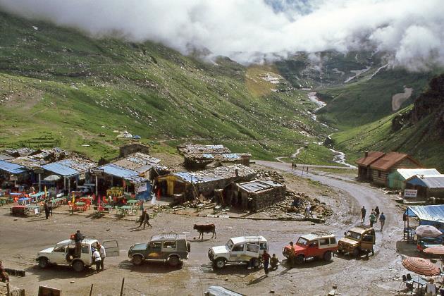
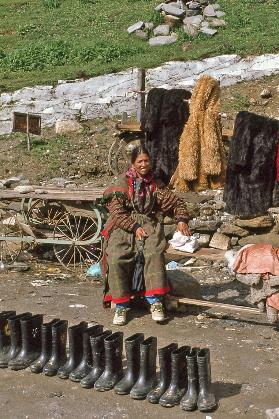
Suddenly, the sun has free rein again. In a hairpin bend, Marhi appears, a scruffy collection of dhabas. Colorful plastic chairs and tables await hungry guests under the blue sky. For truck drivers, such roadside eateries are the designated places to replenish themselves.
It's quite busy; everyone seems to make a brief stop here. We also take a short break. The sun mercilessly burns our skin. Being at 3,320 meters above sea level already takes a bit of our breath away. A woman tries to sell boots. A handful of crows and the obligatory sacred cow pay no attention to all the hustle.
Traffic jam at Rani Nallah |
|
|
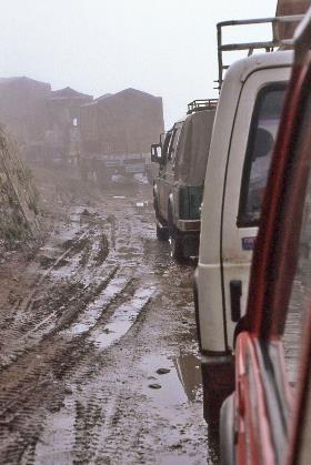
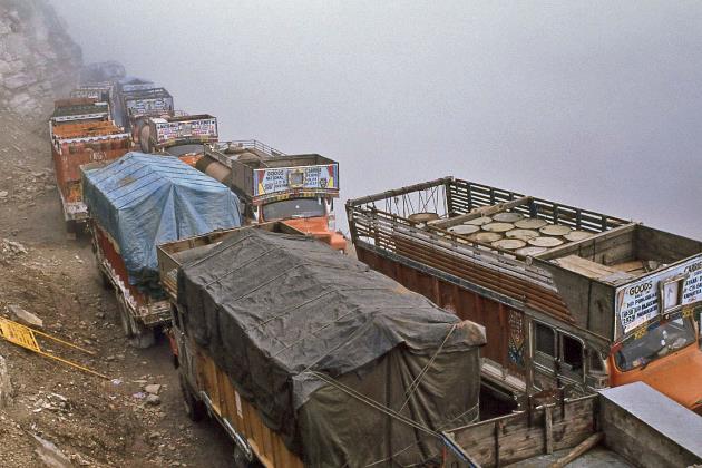
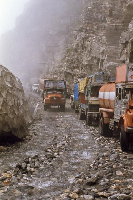
Seventeen more kilometres to climb, and we'll reach the top. The weather is on our side, and we continue with joy. Until we suddenly come across stationary trucks. The line of motionless trucks in the mud seems endless. Everything is stuck, and there is no way through. On the left, the mountain slope rises steeply, and on the right, an unfathomable depth looms. Even the sun decides to stay away. The teasing wind repeatedly gathers the mists and then disperses them again. What exactly is happening is not clear for now. But that it is serious, we have no doubt.
On foot, we set out to explore. Even that is easier said than done. Because in both directions, the trucks stand shoulder to shoulder. Even for a pedestrian, there is sometimes hardly any way through. Unless you dare to venture to the edge of the abyss.
On the left, the mountain slope rises steeply, and on the right, an unfathomable depth looms
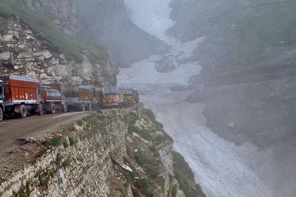
Rani Nallah
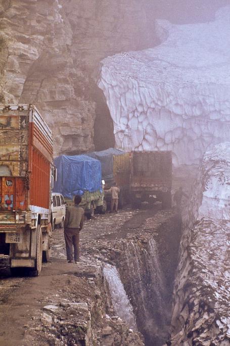
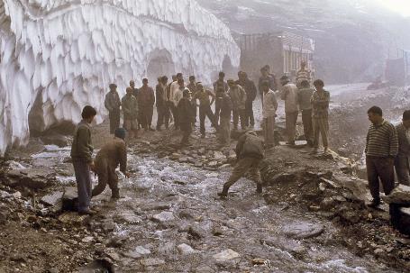
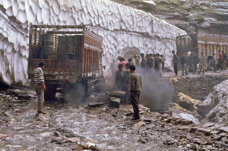
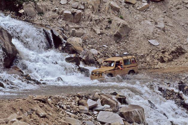
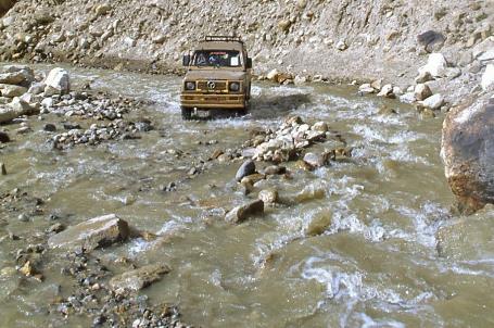
About a kilometre further, it becomes clear what the issue is. The source of all trouble is the narrow glacier tongue of Rani Nallah, which intersects the road in a hairpin bend. Throughout the winter, this mass of snow makes all traffic impossible. However, in the meantime, the bulldozers of the BRO have routinely cleared a strip of about ten meters of snow.
Under the towering glacier wall, melting glacier water flows over the road like a wide stream. This makes the boulders extremely slippery
Rani Nallah |
|
|
That would solve the problem if it weren't for the fact that, from under the towering glacier wall, melting glacier water flows over the road like a wide stream. This makes the boulders extremely slippery. For the descending freight traffic, this poses no problem – they can cautiously descend. The ascending trucks, on the other hand, struggle immensely. Because on these slippery boulders, their tires lack sufficient grip to propel the heavily loaded vehicles upward. From the buzz of the drivers, Anup understands that the problems date back to yesterday evening. Since then, on both sides of Rani Nallah, endless queues of dozens of trucks have formed.
The situation seems hopeless, but that word is unknown to these truckers
Slippery boulders in the glacier meltwater |
|
|
The situation seems hopeless, but that word is unknown to these truckers. Those who take this route are not thrown off balance by such an incident. Perseverance is the motto for the driver in pole position. Encouraged by the cheers of his colleagues, he pushes his roaring engine to the limit and steers his vehicle at full speed into the water, while the exhaust emits jet-black clouds of soot over the white snow wall. Wildly dancing on four wheels, the truck searches in vain for traction on the slippery boulders. However, the rear wheels still have some grip, causing the front to rear up like a rearing horse, then bouncing back onto the boulders in a fountain of water. Powerless, the heavy truck slides back to its original position.
Major problem for the trucks... |
|
Easy task for the jeeps |
For our relatively light jeeps, navigating through this stream would be a breeze, but they are stuck at the tail end of the queue, a kilometre from here. The fact that we don't spot the colonel's truck seems to be the only silver lining in this episode for now because it means he has likely overcome this obstacle.
Then Anup and our drivers start talking to the truckers. It works surprisingly well. At the edge of the abyss, a delicate positional play unfolds. One truck moves forward, another backs up a bit, a third shifts sideways, and this way, our jeeps slowly squeeze through truck by truck. It takes them two hours to cover that thousand meters to Rani Nallah. But once there, they speed through the icy water, leaving everyone behind.
Rohtang La (3 978 m) |
|
Sunny Chandra Valley |
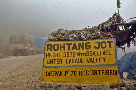
Joyfully, we continue our journey. It's twelve hours when we reach the highest point of Rohtang La, 3,978 meters above sea level. The summit is entirely shrouded in mist, just like the small Hindu temple marking the source of the Beas. An endless number of hairpin bends now swiftly takes us downhill. The contrast with earlier couldn't be greater. The magnificent Chandra Valley is bathed in a sea of light, the sun burns on our skin, and there is no sign of rain or mists anymore. Welcome to the rain shadow of the Lesser Himalaya.
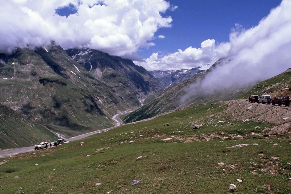
The magnificent Chandra Valley is bathed in a sea of light, the sun burns on our skin. Welcome to the rain shadow of the Lesser Himalaya
But we are quite behind schedule, that cannot be denied. It's almost one o'clock when we reach the bottom of the valley. The journey over Rohtang La has taken us a whopping five hours3).
Literally nothing prevents the rocks from coming down those slopes
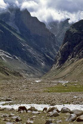
Chandra Valley
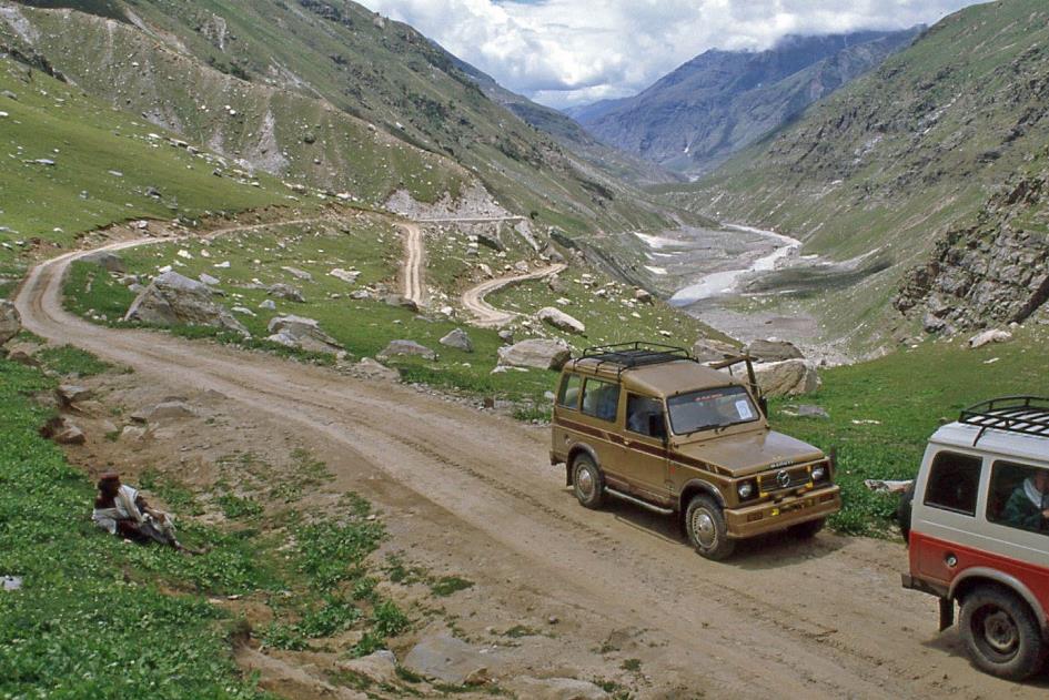
What lies ahead of us seems, at first glance, manageable – just 140 km. However, the unpaved SH 304) road that leads from here to the Spiti Valley does not bode well. And along the way, we have to cross Kunzum La, more than five hundred meters higher than Rohtang La. Assuming we progress at twenty-five kilometres per hour, we'll arrive just before seven in Kaza, the main settlement in the Spiti Valley and our base for the next few nights.
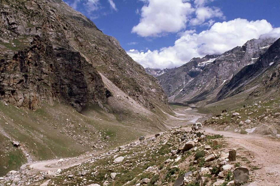
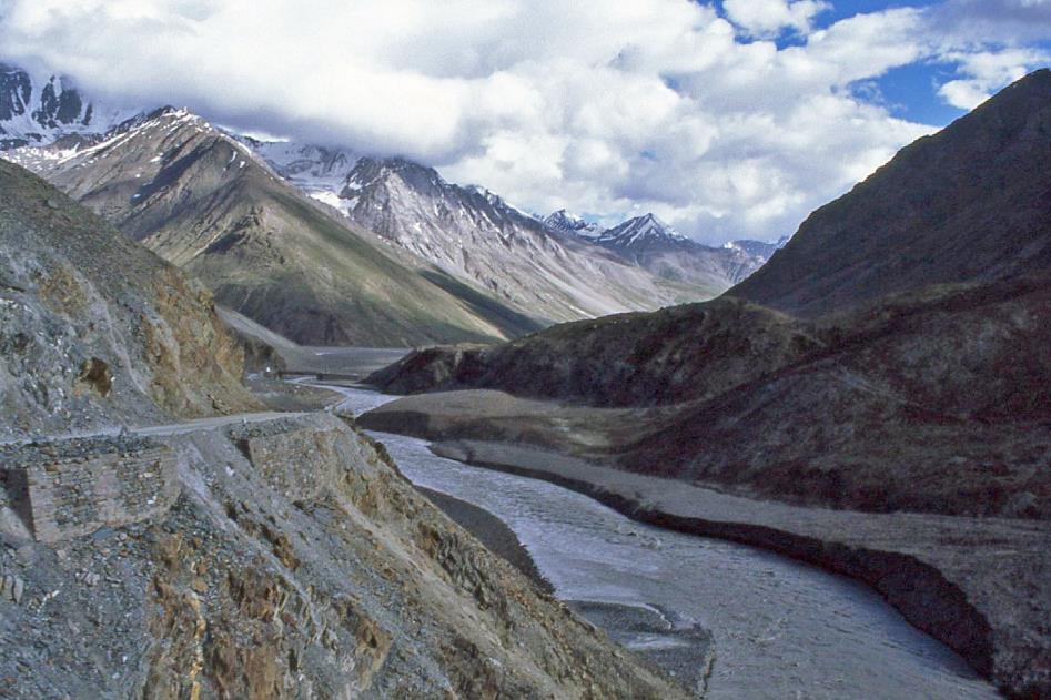
We don't waste any time. A quick picnic on the banks of the Chandra, and then we hit the road again. Upstream, we now follow the wildly turbulent glacier river eastward. The road winds like a fragile ribbon over steep, bare slopes. Literally nothing prevents the rocks from coming down those slopes. And indeed, it happens regularly, whenever prompted by rainfall or an earthquake.
|
|
River crossing |
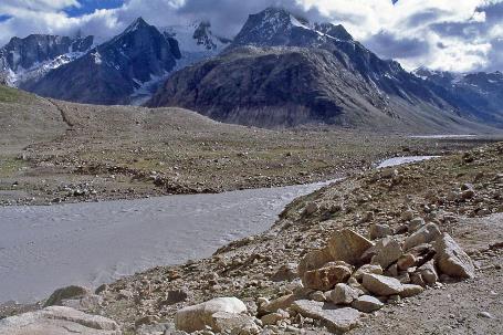
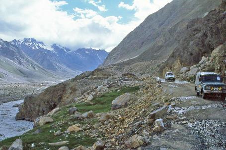
Countless mountain streams cascade down the slopes and cross the unpaved road. However, our jeeps and their experienced drivers have no trouble with these river crossings. Scenes like at Rani Nallah are no longer a concern. We can enjoy the impressive scenery without worry. The sun mercilessly burns in the blue sky, there is not a living creature in sight, not even trees or shrubs. It resembles a lunar landscape, this valley with its barren, colourless slopes. The valley floor is scattered with boulders, as if giants were playing marbles here just a moment ago. Some are the size of small trucks.
|
|
|
It doesn't take much guessing to determine the origin of these boulders. Across the valley, Anup points to Bara Shigri, one of the largest glaciers in the region, a staggering 30 km long. In 1836, the glacier tongue even reached the valley floor, blocking the Chandra. Behind the glacier front, an enormous body of water quickly accumulated, which, in the warmer summer months, suddenly had free rein, leaving a trail of destruction through the valley.
Behind the glacier front, an enormous body of water quickly accumulated, which, in the warmer summer months, suddenly had free rein, leaving a trail of destruction through the valley
But nowadays, searching for that snow-white glacier tongue is in vain. So much debris has accumulated on the ice mass in the form of rocks and soil that the actual glacier is not even visible from here.
|
|
|
Shortly after, we reach Batal, a place that makes you wonder why it got a name, except for the fact that the road to the Spiti Valley starts here. This means leaving the Chandra Valley behind and beginning the ascent to Kunzum La. Only since July 3rd, this route has been open to traffic.
The wild Chandra River
It's a quarter to six when we reach the top of Kunzum La, 4,550 meters above sea level. It went much smoother than expected. We gaze over a gently undulating saddle, where green grass surprisingly persists, and where edelweiss thrives abundantly.
For seven to eight months a year, these valleys live in complete isolation, and even in the summer, they remain challenging to access

The Kunzum La (4,550 m) – Stupa and prayer flags
For seven to eight months a year, these valleys live in complete isolation, and even in the summer, they remain challenging to access. It's evident that customs and traditions have independently evolved over the centuries. What this means for the Spiti Valley becomes immediately clear on this windy mountain pass. Tibetan Buddhism sets the tone, as evidenced by several white stupas adorned with colourful prayer flags.
A little further, a little mountain stream guides us downhill. It's only 75 km from here to Kaza, and mostly downhill. At seven o'clock, we reach the wide Spiti Valley near Losar. It seems we can't go wrong from here.
It seems we can't go wrong from here. But it does go wrong
But it does go wrong. The unpaved road, no wider than a cart track, has not improved over the past few hours. Around half-past seven, darkness falls completely. Meanwhile, it has also started to rain.
Suddenly, in the dancing glow of the headlights, a mudflow appears. Not a mountain stream where water flows cheerfully over the road, but a thick, soggy mud slurry that turns the road into quicksand. Speed is the only solution the jeeps have for this problem. Yet, it also poses dangers. On the right, the mountain slope rises steeply with loose stones, on the left, Anup estimates the pitch-black abyss to be at least several tens of meters deep. In between, the narrow cart track. The slightest deviation to the left or right can be fatal for the jeep and its driver.
Determined, one by one, the drivers launch their jeeps like unstoppable projectiles into the mud. With a fearful heart, we watch as the mud sucks to the tires, the wheels conquer one skid after another, and the tire tracks immediately fill up again after passage. Miraculously, each of the five jeeps reaches the other side unscathed. Then we follow on foot in the icy rain and climb back on board relieved. The fact that the scenario repeats itself a few hundred meters further cannot break our optimism. We are making steady progress, and that's what matters.
In the land where karma is the norm, prevention is an otherworldly fantasy
But then, barely a kilometre further, another mud slurry appears. This time it's serious; this is a mud mountain that seems impassable. Does it make sense to tackle this new obstacle? What else awaits us further in the darkness? Prudently, some drivers set out on foot for exploration. The news they bring back is hopeful. This is the last obstacle worthy of the name.
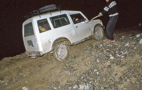
So, they get to work. The jeeps don't carry shovels, tow cables, or flashlights. This is India – in the land where karma is the norm, prevention is an otherworldly fantasy. Fortunately, the rain has stopped by now. The drivers start shovelling the mud away with their bare hands. Then someone unscrews a license plate to use it as a makeshift shovel.
Our supply of luck is depleted; the jeep gets stuck halfway in the mudflow and tilts dangerously towards the abyss
How to tackle a mudslide? |
|
|
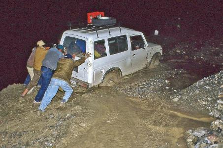
The diligent work doesn't seem to yield much result. Once again, the jeeps will have to rely on speed and brute force. With a strong start, the first driver launches his vehicle. Wobbling, the wheels split the mud, and on either side, the sludge splashes in wide fans. However, our luck has run out; the jeep gets stuck halfway in the mudflow, dangerously tilting towards the abyss.
With much pulling and pushing, the drivers eventually get the jeep to the other side. One by one, the other jeeps follow, not without difficulty – we end up with a flat tire. Finally, we shuffle ourselves to the other side in the light of flashlights – hand in hand, with our backs to the abyss, knee-deep in mud.
It's a quarter to eleven when we enter the pitch-dark Kaza and run into Colonel Pardhan. He is getting ready to meet us and provide food and blankets, convinced that the mudflows would force us to spend the night in the mountains.
Food, clean water, and a metal bed are waiting for us at Hotel Zambala. And even a shower, although it's nothing more than a dusty space with the sole merit of having drainage. We pour the bucket of cold water over our heads, being careful not to extinguish our only light source – the fragile flame of our candle on the floor.
Jaak Palmans
© 2024 | Version 2024-04-27 14:00
Continue reading in (3/5)
Where the gods live
3) According to the plan, in August 2020, the Atal Tunnel between Manali and Keylong is expected to be operational. This 8.8 km tunnel will reduce the total travel time to just thirty minutes.
4) In March 2014, SH 30 was designated as a National Highway under the name NH 505.